


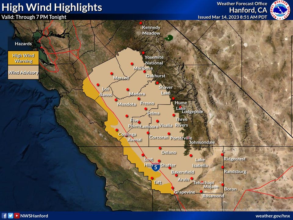
Mariposa could have wind gusts up to 40 mph today
March 14, 2023 - National Weather Service Hanford Office officials report the upcoming wind highlights for the San Joaquin Valley, Sierra foothills and Coastal Range.
Expect 15 to 25mph winds with gusts up to 45 mph in the valley and foothills and 30 to 40mph winds with gusts up to 65 mph in the Coastal mountains.
Area Forecast Discussion
National Weather Service Hanford CA
357 AM PDT Tue Mar 14 2023
.SYNOPSIS...
Another atmospheric river will begin to impact our CWA today into
tonight and move out of the area by tomorrow morning. This system
will bring moderate to heavy rainfall to much of the valley,
foothills, and mountains, which will exacerbate the flooding
already seen by rivers, streams, low lying areas, and poor
drainage areas. Wednesday will have some lingering precipitation,
but then we will have a break from the rain and snow on Thursday
before another system moves into the area on Friday and through
the weekend. While the precipitation storm totals for the weekend
system look weaker than what will fall today, any amount of rain
on already overly saturated soils and warmer snowpack will create
more flooding issues.
&&
.DISCUSSION...
An atmospheric river drawing moisture yet again from the
subtropical Pacific ocean will begin to impact our county warning
area by 5am this morning. The Weather Prediction center has issued
a high chance of excessive rainfall throughout much of our CWA
today. Snow levels are still low with this storm, starting out at
7000 ft, rising and peaking at 8000 ft, and then dropping to 6500
ft by the time the system moves out of the area by late Tuesday
night into early Wednesday morning. High elevation areas will see
large amounts of snow, with 4-6 feet of snow forecasted in areas
like Tioga Pass and Mt. Whitney.
These high rain and snowfall totals combined with already
extremely saturated soils will result in flooding being a major
impact from this storm. Another concern is that per the National
Operational Hydrologic Remote Sensing Center, the snowpack at
higher elevations has warmed and has the potential to melt with
additional storm systems. Areas that will experience flooding
include rivers and streams, low lying areas and poor drainage
areas, and roads along riverbeds. Nuisance flooding will also
impact the San Joaquin Valley and cause ponded roadways and
intersections.
The Sierra and Sierra foothills could see 3-6 inches of rain, with
some isolated higher totals. The eastern San Joaquin Valley could
see 1-2 inches, and the central and western valleys could see half
an inch to an inch. Here are some specific rain totals for areas
within our CWA:
Grant Grove, Shaver Lake, Mt. Whitney: 4-6 inches
Oakhurst, Mariposa, Yosemite Valley, Tioga Pass: 3-4 inches
Fresno, Lake Isabella: 1-1.5 inches
Merced, Madera, Hanford, Visalia, Porterville, Tehachapi,
and The Grapevine: 0.5-1 inch
Mendota, Delano, Lost Hills, Bakersfield: up to 0.5 inch
After this system moves out of the area by Wednesday morning, we
will have a break in precipitation on Thursday before another
system moves in on Friday and continues through the weekend. While
this system has less precipitation associated with it, impacts
could still be moderate to high as already inundated areas will be
receiving more rain and snow. As ensemble model confidence grows,
we will know more information.
&&
.AVIATION...
For the next 24 hours, the San Joaquin Valley will see MVFR
conditions with rain showers and possible IFR conditions in the
Sierra due to mountain obscuration while snow is falling.
&&
.AIR QUALITY ISSUES...
ISSUED: 03/13/2023 14:04
EXPIRES: 03/14/2023 23:59
None.
&&
.CERTAINTY...
The level of certainty for days 1 and 2 is low.
The level of certainty for days 3 through 7 is medium.
Certainty levels include low...medium...and high. Please visit
www.weather.gov/hnx/certainty.html for additional information
and/or to provide feedback.
&&
.HNX WATCHES/WARNINGS/ADVISORIES...
Flood Watch through Wednesday morning for CAZ300>336.
Winter Storm Warning until 5 PM PDT Wednesday for CAZ323-326>331.
Source: NWS

