


California and National Drought Summary for March 21, 2023
Summary
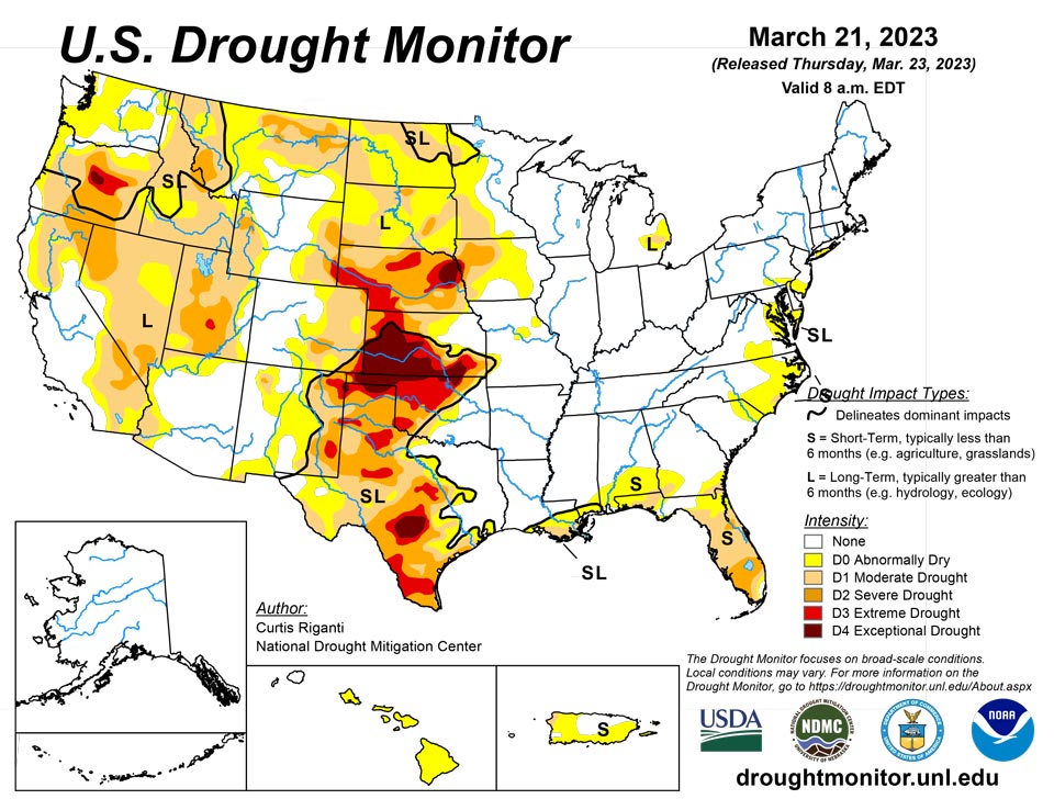
March 23, 2023 - This week, heavy precipitation fell in parts of the West, especially in California, while drier weather generally occurred in the Great Plains east of the Rocky Mountains. Heavier precipitation also fell along parts of the Rio Grande in Texas, leading to some improvements of drought conditions there. Widespread precipitation amounts at or above a half inch fell in east Texas eastward into the Southeast, and from near Interstate 44 in Oklahoma eastward into Arkansas and southern Missouri. New York and southern New England also saw near a half inch of precipitation this week, with localized higher amounts. Dry weather continued in parts of the Florida Peninsula, where severe drought coverage increased in several areas. In response to rainfall in central Puerto Rico but continued dry conditions in the northwest, abnormal dryness coverage shifted a bit there. Recent dry weeks in Hawaii led to decreased streamflows and the introduction of abnormal dryness on all islands except Kauai and Niihau. For more detailed information for each region, please refer to the paragraphs below.
Northeast
Widespread precipitation fell in parts of the Northeast this week, especially in eastern Massachusetts and central New York, where amounts of 1 inch or more were common. Drier weather enveloped Delaware, most of New Jersey, southeast Pennsylvania, Maryland and northern Maine. Due to short-term precipitation deficits and some shortages in streamflow and soil moisture, a few areas of abnormal dryness grew in southeast Pennsylvania, Maryland, the District of Columbia and New Jersey. Long-term moderate drought also continued on the southern end of the Delmarva peninsula. Aside from some lingering abnormal dryness in the eastern part of Long Island, the rest of the Northeast region remained free from drought or abnormal dryness.
Southeast
Precipitation in the Southeast region was a mixed bag this week. Virginia, North Carolina and South Carolina were relatively dry this week, and drought and/or abnormal dryness coverage increased in these states, where streamflows and soil moisture decreased amid growing short-term precipitation deficits. A marsh fire covering 500 acres occurred in one of the moderate drought areas that developed this week in northeast North Carolina. Heavier precipitation amounts, locally up to 1.5-2 inches, fell in parts of the Florida Panhandle and adjacent southern Alabama and Georgia, leading to localized improvements in abnormal dryness in south-central Georgia. Moderate drought coverage in southwest Georgia increased slightly due to growing short-term precipitation deficits and soil moisture deficits. Short-term severe drought expanded in coverage in south Florida, where soil moisture decreased amid growing fire danger and growing short-term precipitation deficits. Severe drought also developed in a small part of northeast Florida amid similar conditions to those farther south in the Florida Peninsula.
South
Widespread precipitation amounts of at least a half inch fell across the eastern two-thirds of the region, with localized spots in far east Texas, Louisiana, southwest Mississippi and central Arkansas reaching 2 inches. Oklahoma northwest of Interstate 44 and much of central and west Texas had mostly dry weather this week. Exceptions to this occurred in many areas along the Rio Grande from the Big Bend east in southern Texas, which received localized heavier precipitation amounts from 0.5 to 2 inches. Temperatures across the South region this week were generally 5 to 15 degrees cooler than normal. Continued dry conditions in the Oklahoma and Texas panhandles led to expansions of severe and exceptional drought where soil moisture and groundwater levels continued to drop. In the northern Texas Panhandle, the winter wheat crop is in danger of total failure, which is indicative of the soil moisture and precipitation deficit problems in the area. In areas that mostly missed out on heavier rains in central Texas, streamflow continued to drop amid growing precipitation deficits, leading to expansion of drought and abnormal dryness in some locations. Farther south, in the Big Bend region and in south-central Texas, localized improvements were made due to benefits from recent heavier rainfall. Ongoing short- and long-term drought and abnormal dryness remained unchanged in southern Louisiana and Mississippi, and the rest of the region remained free of drought or abnormal dryness.
Midwest
Most of the Midwest region saw temperatures range from 5 to 15 degrees colder than normal this week, with scattered areas receiving up to 1 inch or so of precipitation while some regions remained mostly dry. In southeast Lower Michigan, long-term moderate drought decreased in coverage as recent precipitation alleviated long-term precipitation deficits. A few spots in central and eastern Missouri saw small areas of abnormal dryness develop where streamflows and soil moisture decreased. Abnormal dryness and moderate and severe drought expanded slightly eastward in southeast Kansas and southwest Missouri, where streamflows and soil moisture decreased amid mounting short-term precipitation deficits. Otherwise, few changes were made to the USDM depiction in the region, and Illinois, Kentucky, Ohio, Indiana and Wisconsin remained free of drought or abnormal dryness.
High Plains
Temperatures in the High Plains region were mostly below normal for the week. The most significant departures occurred in the Dakotas, where temperatures mainly ranged from 15 to 25 degrees colder than normal outside of southwest South Dakota. Precipitation fell in some of the high elevation areas of Colorado and Wyoming this week; otherwise, the weather was mostly dry in the High Plains region. Moderate and severe drought expanded slightly in southeast Kansas; please see the Midwest paragraph for more details on this. Due to recent snowfall and lessening precipitation deficits, portions of northwest North Dakota saw reductions in moderate and severe long-term drought coverage. Otherwise, ongoing long-term drought was unchanged east of the Rocky Mountains. In north-central South Dakota, stock pond levels and river levels remained low, despite some recent snowmelt, indicative of long-term dryness there. Parts of the Sangre de Cristo Mountains and far eastern San Luis Valley saw some improvements due to increased snowpack. Increased recent precipitation in southwest Wyoming allowed for the removal of severe drought.
West
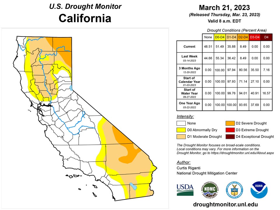
Most of the West saw temperatures near or below normal for the week, with a few areas of temperatures between 10 and 15 degrees below normal occurring in the Intermountain West, especially in Utah, Idaho, Nevada and Oregon. Widespread precipitation in the form of rain and snow, with localized very heavy amounts, occurred in parts of the region, especially in the San Bernardino and Sierra Nevada Mountains in California. A few spots in the northern Sierra Nevada saw improvements where snowpack increased further. Lush vegetation was reported in San Bernardino County, California, indicative of the very wet recent weather. The effects of recent wet weather will continue to be analyzed in the coming weeks over this area, and slight improvements to lingering abnormal dryness were made in southwest California this week. Large areas of severe and extreme drought in northern Nevada, northern Utah, Oregon, southern Idaho and northern Montana saw improvements due to recent precipitation and lessening precipitation deficits. Due to increased soil moisture and lessened precipitation deficits, improvements to ongoing long-term drought and abnormal dryness were also made in southeast Arizona and southwest New Mexico, and in portions of south-central and northwest New Mexico.
Caribbean
Heavier rains fell in central Puerto Rico this week, and some of the short-term abnormal dryness was removed on the southern end of the heavier rainfall. Mounting short-term precipitation deficits led to a slight expansion of abnormal dryness in northwest Puerto Rico; the moderate drought area in northwest Puerto Rico did not change this week.
Rain was scarce for parts of the U.S. Virgin Islands this week with rainfall totals less than 1 inch. In St. Thomas, the Cyril E. King Airport had the most rain with 0.88 inch of rain. The month-to-date rainfall total at the airport was 1.11 inches or 96% of normal and 3.85 inches (68% of normal) for the year-to-date. Several CoCoRaHs stations had weekly rainfall totals between 0.14 to 0.25 inch and monthly totals between 0.29 to 0.63 inch. SPI values for the airport are indicative of drought free conditions at the 1, 6, 9, and 12 months, while the 3-month period is indicative of abnormally dry conditions. Despite indices showing some drought improvement, local input suggests that vegetation is showing signs of stress and trees and bushes are losing their leaves. According to the USGS Grade School 3 Well, groundwater levels are slowly decreasing as well. For these reasons, moderate drought conditions continued for St. Thomas.
The drought classification for St. Croix was changed from moderate to severe drought this week due to lack of rain. In St. Croix, the Henry Rohlsen Airport had no rain this week. The month-to-date rainfall total is 0.01 inch, which is only 1.1% of normal rainfall for the month. The year-to-date total of 2.68 inches is 63% of normal rainfall. CoCoRaHs stations across St.Croix had weekly rainfall totals that ranged between 0.01 to 0.21 inch and monthly totals between 0.03 to 0.35 inch. SPI values at the 1, 3, and 6 months are indicative of moderate to exceptional drought, while the 9 and 12 months were indicative of drought free conditions. Groundwater levels were also decreasing and information from a local newspaper suggests that there are growing concerns of insufficient water for irrigation from farmers.
Abnormally dry conditions continued across St. John this week. CoCoRaHs station VI-SJ-5 had 0.09 inch of rain and 0.26 inch at VI-SJ-3. The month-to-date totals were 0.18 inch (VI-SJ-5) and 0.35 inch (VI-SJ-3; 17.9% of normal). SPI value is indicative of extreme drought at the 1-month period, but drought free for the 3, 6, 9, and 12 months.
Pacific
Alaska remained free of drought or abnormal dryness this week.
Following a wetter period, dry weather in Hawaii over the last few weeks and an attendant decrease in streamflows led to the development of abnormal dryness on Oahu, Molokai, Kahoolawe, Lanai, Maui and the Big Island. Kauai and Niihau remained free of abnormal dryness, and the entire state remained free of drought.
Drought free conditions continued across Palau. Koror had 5 inches of rain this week, resulting in a month-to-date total of 9.56 inches.
Rainfall was scarce across parts of the Marianas. Rota and Saipan had only 0.23 and 0.30 inch of rain so far this week, respectively. Guam had the most rain at 1.08 inches for the week and a month-to-date rainfall total of 3.86 inches, which is close to the 4 inches monthly threshold to meet most water needs. Meanwhile, Rota and Guam had a little over 1 inch for the month-to-date total. Drought free conditions persisted for Guam and Rota at this time. Rota had over 6 inches of rain in Feb. Saipan continued to be free of drought since last week they received close to 1 inch of rain and there were no drought impacts reported at this time.
Across the Federated States of Micronesia (FSM), beneficial rains fell across several locations with rainfall totals over 2 inches. Kapingamarangi had the most rain (4.18 inches) this week. Moderate drought was not changed since it had less than 4 inches of rain in February and the dry conditions continued at least through mid-March. Similarly, Lukunoch and Pingelap continued to be abnormally dry despite having some recent beneficial rains. However, if wet conditions persist next week, a 1-category drought improvement will be considered for Kapingamarangi, Lukunoch and Pingelap. Drought free conditions persisted across the other locations across the FSM.
Much of the Marshall Islands had a dry week. Wotje and Kwajalein continued to be in moderate drought since they had little to no rain. Ailinglaplap and Jaluit had less than half an inch; however, drought free conditions persisted for these locations since Ailinglaplap had over 4 inches of rain last week and Jaluit had some beneficial rains the last two weeks. Mili had 4 days of missing data; however, drought free conditions were unchanged since it had close to 4 inches of rain last week, 6.89 inches for the month-to-date, and over 21 inches during Feb 2023. Majuro was the only location to have a wet week with over 4 inches of rain this week. Drought free conditions continued for Majuro.
Drought was not a concern across American Samoa since all three locations had over 1 inches of rain this week and over 4 inches of rain for the month-to-date.
Looking Ahead
Through the afternoon of Monday, March 27, the National Weather Service Weather Prediction Center is forecasting mainly dry weather in the northern Great Plains, Minnesota and northwest Wisconsin. Mostly dry weather is also forecast in most of the Florida Peninsula, where short-term moderate and severe drought has intensified recently. Aside from some of the higher elevation areas, mostly drier weather is forecast in southern Nevada, southeast California, Utah and New Mexico. Heavier precipitation amounts are forecast for parts of western Oregon and Washington and far northwest California. Heavy rainfall, locally up to or exceeding 3 inches, is forecast along and south of the Interstates 44 and 70 corridors from far northeast Oklahoma into Ohio. Widespread rain amounts of at least 1.5 inches are likely in the northern halves of Georgia, Alabama and Mississippi, and in the southwest half of Tennessee. Widespread precipitation amounts of 0.5-0.75 inches are likely in much of the Northeast, with localized higher amounts.
For the period from March 28-April 1, the National Weather Service Climate Prediction Center’s forecast strongly favors above-normal precipitation in most of the West, especially central and southern California. Above-normal precipitation is also likely in Tennessee and portions of the surrounding states. Most of the Great Plains, except for the area stretching from southeast New Mexico to western Kansas, is slightly favored to receive above-normal precipitation, as is the Upper Midwest and most of the Northeast. Below-normal precipitation is weakly favored in the southern half of the Florida Panhandle. Above-normal precipitation is likely in most of Alaska, except for far southeast Alaska, where below-normal precipitation is favored. The temperature outlook strongly favors colder-than-normal weather across most of the West, especially California and Nevada, with most of the northern contiguous U.S. also leaning toward colder-than-normal temperatures. The entire Gulf Coast region is more likely to have warmer-than-normal temperatures, with the highest probabilities for above-normal temperatures existing in the Florida Panhandle. Warmer-than-normal temperatures are favored in northeast Alaska, while colder-than-normal weather is more likely in southeast Alaska.
Author(s):
Curtis Riganti, National Drought Mitigation Center
Ahira Sanchez-Lugo, NOAA/NCEI
Dryness Categories
D0 Abnormally Dry—used for areas showing dryness but not yet in drought, or for areas recovering from drought.
Drought Intensity Categories
D1 Moderate Drought
D2 Severe Drought
D3 Extreme Drought
D4 Exceptional Drought
Drought or Dryness Types
S Short-term, typically less than 6 months (agriculture, grasslands)
L Long-term, typically more than 6 months (hydrology, ecology)
SL Area contains both short- and long-term impacts
Source: National Drought Mitigation Center

