


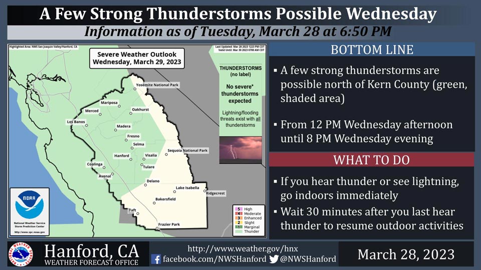
Includes Fresno, Merced, Madera and Mariposa Counties and Yosemite National Park
March 29, 2023 - National Weather Service officials report a few strong thunderstorms are possible north of Kern County from 12:00 P.M. Wednesday afternoon until 8:00 P.M. Wednesday evening.
Small hail and wind gusts near 45 miles per hour are a couple of hazards associated with strong thunderstorms.
In addition to dangerous cloud to ground lightning strikes, any thunderstorm can produce intense rainfall rates, leading to localized flooding.
Area Forecast Discussion
National Weather Service Hanford CA
211 AM PDT Wed Mar 29 2023
.SYNOPSIS...
Showers continue to push through the region this morning bringing
rain for lower elevations and heavy snow for the Sierra Nevada.
Thunderstorms this afternoon are possible for much of the area
bringing an increased threat to heavy precipitation and increased
flood concerns. A light, showery pattern is likely to unfold
Thursday, with dry conditions Friday and Saturday. A return to
showery activity next week may occur.
&&
.DISCUSSION...
Showers this morning continue to press eastward bringing periods
of heavy rainfall for valley locations and foothills and heavy
snowfall for the Sierra Nevada above 3,000 feet. Periods of
intense rainfall warranted the issuance of a FLOOD WATCH for much
of the foothills due to excessive rainfall. Soils have had little
to no time to dry out from the previous events creating ideal
runoff conditions. This has had great impacts on surrounding
creeks, streams, and rivers.
The bulk of the precipitation will push eastward this morning
with much more showery conditions for the remainder of the
afternoon and evening in store for Wednesday. Thunderstorms are
expected to develop this afternoon bringing periods of heavy
rainfall to already saturated soils.
The weekend will bring drier conditions back to the region with
temperatures peaking near 70 degrees for valley locations. By the
start of next week, models are indicating a return to wet weather
with a series of storms slated to push through on the long range
global guidance. Some definite spread among the models leads to
lower confidence on timing for next week, but wetter conditions
do look promising for the start of next week.
&&
.AVIATION...
VFR conditions will prevail for the next 24 hours. However, areas of
MVFR and IFR conditions are possible in heavier showers in the
Valley and mountain obscurations.
&&
.AIR QUALITY ISSUES...
ISSUED: 03/28/2023 13:17
EXPIRES: 03/29/2023 23:59
None.
&&
.CERTAINTY...
The level of certainty for days 1 and 2 is high.
The level of certainty for days 3 through 7 is medium.
Certainty levels include low...medium...and high. Please visit
www.weather.gov/hnx/certainty.html for additional information
and/or to provide feedback.
&&
.HNX WATCHES/WARNINGS/ADVISORIES...
Wind Advisory until 5 AM PDT Thursday for CAZ337-339.
Wind Advisory until 5 AM PDT early this morning for CAZ300-308-
313.
Flood Watch through late tonight for CAZ317>322.
Winter Storm Warning until 11 PM PDT this evening for CAZ318-320-
322>331.
Winter Weather Advisory from 5 AM early this morning to 11 AM
PDT Thursday for CAZ333>336.
Source: NWS

