


California and National Drought Summary for April 4, 2023
Summary
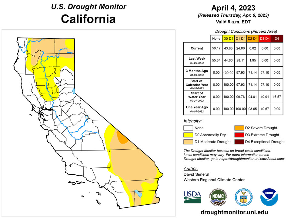
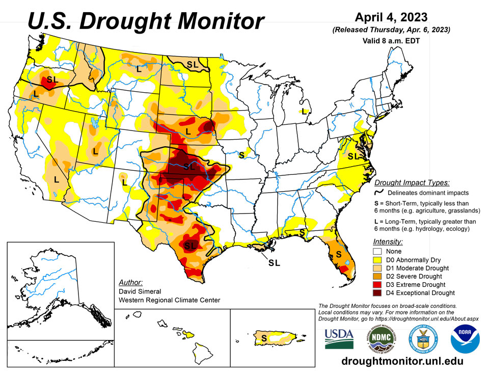
April 6, 2023 - This U.S. Drought Monitor (USDM) week saw continued widespread improvements on the map across areas of the western U.S. including in California, Nevada, Oregon, Idaho, and Utah. Overall, the areal extent of drought in the West dipped to 31% this week as compared to 73% at the beginning of the Water Year in early October. This week’s improvements reflected the impact of the recent storm events which continued to boost mountain snowpack levels to record, or near-record levels as observed at numerous Natural Resources Conservation Service (NRCS) SNOTEL monitoring stations across the Sierra Nevada, southern Cascades, eastern Great Basin, Wasatch, Uintas, and the southern and central Rockies. In California, the statewide snowpack was 243% of normal (April 5), with the Northern Sierra at 198%, Central Sierra at 242%, and Southern Sierra at 302%. Elsewhere in the region, the state of Utah is observing historic snowpack levels with the statewide snow water equivalent (SWE) at its highest level on record (April 5) at 211% of median, according to NRCS SNOTEL. In other regions, areas of the South (Texas) and the Southern Plains (Kansas, Oklahoma) saw further degradations on the map in response to a combination of short and long-term dry conditions, very low streamflow and reservoir levels, and reported impacts in the agricultural sector. In the High Plains, blizzard-like conditions and moderate to heavy snowfall accumulations were observed in the Dakotas during the past week as well as in areas of the Upper Midwest including northwestern Minnesota. In the Southeast, dry conditions and reports of deteriorating pasture conditions led to the expansion of severe drought areas in central Florida. Likewise, short-term precipitation deficits and increasing fire danger in areas of the Coastal Plain of North Carolina led to the expansion of areas of drought.
Northeast
Some minor changes were made on the map including the expansion of Moderate Drought (D1) in areas of Delaware and eastern Maryland in response to a combination of factors including short-term precipitation deficits (past 30-60-day period), low streamflows (<5th percentile), and pockets of below-normal soil moisture. Likewise, short-term dryness and widespread low streamflows led to the introduction of new areas of Abnormally Dry (D0) in northern New Jersey, eastern Pennsylvania, and central Maryland. During the past week, precipitation accumulations (liquid) were light (<1 inch) with light snowfall accumulations observed in Upstate New York as well as northern portions of Vermont, New Hampshire, and Maine. Average temperatures ranged from 1 to 6 deg. F below normal in the northern extent of the region, while temperatures were near normal to slightly above normal in the southern third of the region. According to the NWS National Operational Hydrologic Remote Sensing Center (NOHRSC), the Northeast Region is currently (April 4) 55.5% snow-covered (43.4% on April 4, 2022) with an average snow depth of 9.3 inches (5.0 inches in 2022) and a maximum depth of 69.9 inches (46.1 inches in 2022).
Southeast
During the past week, light-to-moderate rainfall accumulations (1 to 4 inches) were observed across the region with heavy rainfall observed in isolated areas of Alabama, southeastern Georgia, and in the Florida Panhandle. Elsewhere, conditions were generally on the dry side leading to further expansion of areas of Severe Drought (D2) in central Florida as well as slight expansion of Moderate Drought (D1) in areas of the Coastal Plain of North Carolina in response to a combination of both short and long-term drought indicators. For the past 6-month period, precipitation deficits across the Coastal Plain region ranged from 3 to 9 inches. Similarly, much of Florida has experienced dry conditions during the past 30-120-day period with precipitation deficits ranging from 2 to 9 inches. For central Florida, the National Drought Mitigation Center’s Condition Monitoring Observer Reports (CMOR) website is reporting numerous impacts of very-dry conditions in the region including water holes drying up and areas experiencing extremely poor pasture conditions with supplemental feeding necessary to maintain livestock conditions. Moreover, according to the USDA for the week ending April 2, topsoil moisture rated short to very short in Florida was 48%. For the week, average temperatures ranged from 4 to 8 deg. F above normal across Florida, while the Carolinas, Georgia, and portions of Alabama hovered within a few degrees of normal.
South
In the South, a major outbreak of severe weather impacted portions of the region, including in the Mississippi and Tennessee valleys where numerous tornadoes touched down. The severe weather outbreak included strong thunderstorms with excessive rainfall, large hail, damaging winds, and violent tornadoes which impacted areas of Arkansas and Tennessee, leading to loss of lives and the destruction of homes and businesses. On the map, areas of drought intensified and expanded across areas of Texas and Oklahoma where precipitation deficits during the past 12-month period ranged from 8 to 20 inches in the most severely affected areas. According to the USDA (April 2), the percentage of topsoil moisture in Texas and Oklahoma that was rated short to very short was 72% and 63%, respectively. Moreover, numerous reservoirs in the western half of Texas were below normal levels, including the San Antonio River Basin reservoirs which are currently 5.3% full, according to Water Data for Texas. In terms of streamflow levels, areas of Oklahoma (northern and western) and Texas (Hill Country and South Texas Plains regions) observed 7-day streamflows in the <10th percentile range, according to the U.S. Geological Survey. For the week, average temperatures were above normal (1 to 8 deg. F) across the region with the greatest departures observed along the Gulf Coast and South Texas Plains.
Midwest
During the past week, several outbreaks of severe weather impacted the region starting late last week and carrying over into early this week. The severe weather included strong thunderstorms, locally heavy rainfall, large hail, and damaging winds as well as tornadoes reported in Illinois, Iowa, and Missouri. Further to the north, several storm systems impacted the Upper Midwest bringing a mix of weather conditions including snow, sleet, freezing rain, and drizzle. For the week, precipitation accumulations ranged from light to moderate (1 to 4 inches) with the heaviest accumulations observed in southeastern Minnesota, northern Wisconsin, and southern Michigan. On the map, only minor changes were made including the removal of an area of Moderate Drought (D1) in southeastern Michigan in response to above-normal precipitation during the past several months as well as improved streamflow conditions. Additionally, two areas of Moderate Drought (D1) were trimmed back in western Minnesota. Looking at the regional snow analysis from NOAA NOHRSC (April 4), the Northern Great Lakes Region is currently 48.5% snow-covered (61.2% on the same date in 2022) with an average depth of 9.4 inches (5.4 inches in 2022) and a maximum depth of 44.8 inches (49.3 inches in 2022).
High Plains
On this week’s map, changes were made including a slight expansion of an area of Exceptional Drought (D4) in central Kansas as well as one-category improvements in areas of Moderate Drought (D1) and Severe Drought (D2) in South Dakota in response to improving soil moisture conditions, snow cover, and above-normal precipitation during the past 30-90-day period in some areas. Currently, 50% of Kansas is depicted in the D3-D4 drought categories with 12-month precipitation deficits ranging from 4 to 16 inches. According to the latest USDA Kansas Crop Progress and Condition report (April 3), winter wheat conditions were rated 31% very poor, 26% poor, 27% fair, 14% good, and 2% excellent. In terms of topsoil moisture conditions (April 2, USDA), the percentage of topsoil moisture rated short to very short was 73% in Kansas and 56% in Nebraska. In the Northern Plains, blizzard-like conditions were observed during the past week bringing heavy snowfall to eastern Wyoming, northwestern Nebraska, and the Dakotas. According to NOAA NOHRSC, 72-hour snowfall accumulations as of April 5 ranged from 6 to 24 inches. For the week, average temperatures were well below normal with departures ranging from 5 to 25 deg. F below normal with the largest departures observed in North Dakota.
West
Out West, widespread improvements were made on the map including areas of California, Nevada, Oregon, Idaho, Utah, Montana, Wyoming, and New Mexico in response to excellent snowpack conditions across many of the drainage basins in the region. In California, the statewide snowpack (April 5) was 243% of normal, with the Northern Sierra at 198%, Central Sierra at 242%, and Southern Sierra at 302%. The California Department of Water Resources reported that the 2022-23 season will go down as one of the largest snowpacks on record in California. In Nevada and Utah, current SWE percentages of median for select basins are as follows: Central Lahontan 273%, Central Nevada Desert Basins 267%, Great Salt Lake 224%, Lower Green 202%, Upper Colorado-Dolores 207%, and Upper Colorado-Dirty Devil 219%, according to the NRCS SNOTEL network. In Arizona and New Mexico, snowpack levels are above normal, especially in the ranges of northern and central Arizona. In Arizona, the total reservoir system (Salt and Verde River system) is currently 100% full as compared to 72% full at the same time last year, according to the Salt River Project. For the Colorado River system, the U.S. Bureau of Reclamation is reporting (April 4) Lake Mead at 28% full and Lake Powell at 23% full.
Caribbean
In Puerto Rico, a combination of short-term precipitation shortfalls (2 to 4 inches) during the past month and low streamflows led to an expansion of areas of Moderate Drought (D1) across the island.
Most of the U.S. Virgin Islands have remained in drier-than-normal conditions. The satellite data (i.e., National Weather Service’s seven-day quantitative precipitation estimates) and station observations show that the rainfall amount received over most parts of the islands was less than 1 inch. The short-term (one- and three-month) Standardized Precipitation Index (SPI) maps showed that conditions have been drier than normal across the three islands.
Specifically, St. John (Rafe Boulon/Windswept Beach) reported 0.28 inches of rain this week. The depth to water level at Susannaberg DPW 3 well (St. John, USVI) on April 4 was 14.26 ft below land surface. Thus, St. John remains at the status quo of abnormally dry condition.
Only 0.01 inches of rain was reported at Cyril E. King Airport, St. Thomas, this week. There is an increase in depth of water level at St. Thomas. The depth to water level Grade School 3 well (St. Thomas, USVI) on April 4 was 11.85 ft below land surface, showing that the water level is significantly increasing (deeper) since November 2022. Thus, St. Thomas remained in short-term moderate drought (D1-S) condition.
St. Croix (Henry Rohlsen AP) reported 0.30 inches of rain this week. There was also an increase in depth to water level at St. Croix. The depth to water level at Adventure 28 Well (St. Croix, USVI) on April 4 was about 29.43 ft below land surface. This indicates a significant increase in the depth of water level since November 2022. Thus, St. Croix remains in severe drought condition for this week.
Pacific
In Alaska, no changes were made on the map this week and the state remained drought-free. According to the NRCS SNOTEL network, near-normal to above-normal SWE levels are being reported across all observed basins in Alaska.
In the Hawaiian Islands, some minor changes were made on the map this week including the removal of all areas of Abnormally Dry (D0) on Oahu, Molokai, and Lanai as well as trimming of D0 areas on the Big Island in response to beneficial rainfall during the past week. On Maui, an area of Moderate Drought (D1) was introduced on the windward side of the West Maui Mountains where rainfall has been below normal during the past month and streamflow levels are low.
Heavy rains were observed on some parts of the Marshall Islands this week. Ailinglapalap received 3.31 inches of rain this week. Similarly, 4.34 inches of rain was reported on Majuro, allowing the island to be free of drought. On Mili, 2.17 inches of rain was reported this week, allowing the island to be drought free. However, while rainfall across the southern part of the atoll has been near average, the far western and northern parts of Marshall Islands have been drier than normal. Roi Namur on the northern end of the atoll had 1.76 inches of rain in March. Roi saw a very dry February after a wet December and January. Jaluit received 0.70 inches of rain with one day missing, deteriorating to abnormally dry condition. Wotje reported no rain (two days missing) this week. In addition, Wotje observed little or no rain for several weeks (since January 2023). Thus, Wotje remained in short-term severe drought. Similarly, Kwajalein reported only 1.83 inches of rain this week. Only 0.68 and 0.34 inches of rain were observed on Kwajalein in the past couple of weeks, and the island remains in moderate drought. No depiction was made for Utirik due to missing data.
This week, wet conditions were observed across the Mariana Islands. The amount of rainfall observed on Saipan (IAP, manual gauge) was 3.39 inches. Thus, Saipan remains drought free this week. Rainfall amounts on Guam and Rota were 0.76 and 0.46 inches (one day missing), respectively.
American Samoa remained free of drought this week. Pago Pago and Toa Ridge (NPS in American Samoa) received 3.06 and 1.11 inches of rain, respectively. With one day missing, Siufaga Ridge (NPS in American Samoa) reported 1.2 inches of rain.
Palau IAP (Airai) reported 2.48 inches this week. Koror COOP station also reported 0.64 inches of rain, allowing the island to be drought free.
Most parts of the Federated States of Micronesia remained drought free this week. Good rains have returned as the climate pattern continues to trend toward the warm side of ENSO neutral. This week, only 0.72 inches of rain was reported on Kapingamarangi with three days missing. However, Kapingamarangi had significant rains in the last two weeks of March (4.18 and 4.45 inches), improving the island to long-term abnormally dry condition. On Kosrae, 1.64 inches of rain was reported this week (with three days missing). Because of the wet conditions in the past few months, Kosrae remained drought free. On Lukunor, only 0.32 inches of rainfall was reported this week (with five days missing). Wet conditions (4.61 inches of rain) were observed in the last week of March, allowing the island to remain drought free. On Nukuoro, 2.36 inches of rain was reported this week (three days missing), allowing the island to be free of drought or abnormal dryness. This week, 2.95 inches of rain was reported on Pingelap with three days missing, allowing the island to improve to drought free condition. On Yap, only 1.92 inches of rain was reported this week. However, because of wet conditions in January, Yap remained free of dryness. On Ulithi, only 0.97 inches of rain was reported this week (two days missing). About 14 inches of rain was reported in January. In addition, 2.47 inches of rain was observed on Ulithi during the week of March 21, allowing the island to be drought free.
On Woleai, 2.71 inches of rain was reported this week (two days missing), so it remains drought free. This week, heavy rain (5.42 inches) was reported on Pohnpei with three days missing, so the island remained free of dryness. At Chuuk, 1.38 inches of rain was reported this week with three days unaccounted for, allowing the island to be free of dryness. No depiction was made for Fananu due to missing data.
Looking Ahead
The NWS WPC 7-Day Quantitative Precipitation Forecast (QPF) calls for moderate-to-heavy precipitation accumulations (including heavy snowfall accumulations) ranging from 2 to 7+ inches (liquid) across the Cascades of Oregon and Washington, Klamath Mountains, and Coast Ranges of northwestern California. Meanwhile, light accumulations are expected in the mountain ranges of eastern Oregon and Washington, central and northern Idaho, and across areas of the northern Rockies. Elsewhere in the conterminous U.S., heavy precipitation accumulations (2 to 5+ inches) are expected in the Gulf Coast region of Texas and the South, while the Southeast (excluding Florida) is forecasted to have light-to-moderate precipitation accumulations (2 to 4 inches). In isolated areas of the Upper Midwest and Northeast, light precipitation (<1 inch) is forecasted. The CPC 6-10-day Outlooks call for a moderate-to-high probability of above-normal temperatures across much of the conterminous U.S. with exception of areas to the west of the Continental Divide where cooler than normal temperatures are expected. Precipitation is forecasted to be above normal across Alaska, the Pacific Northwest, Intermountain West, the Plains states, and in Florida. Below-normal precipitation is forecasted across the South, Eastern Tier, and portions of the Midwest.
Author(s):
David Simeral, Western Regional Climate Center
Tsegaye Tadesse, National Drought Mitigation Center
Dryness Categories
D0 Abnormally Dry—used for areas showing dryness but not yet in drought, or for areas recovering from drought.
Drought Intensity Categories
D1 Moderate Drought
D2 Severe Drought
D3 Extreme Drought
D4 Exceptional Drought
Drought or Dryness Types
S Short-term, typically less than 6 months (agriculture, grasslands)
L Long-term, typically more than 6 months (hydrology, ecology)
SL Area contains both short- and long-term impacts
Source: National Drought Mitigation Center

