


California and National Drought Summary for April 18, 2023
Summary
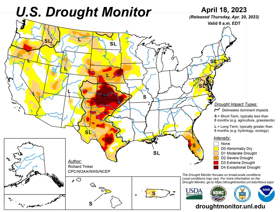
April 20, 2023 - While most of the country received light precipitation at best last week, large totals fell on a few areas. Over 1.5 inches fell on the south half of Mississippi and the central Gulf Coast Region from Louisiana through the Florida Panhandle, with totals of 4 to 6 inches dousing parts of southeast Mississippi, southern Alabama, and coastal Louisiana. Totals also exceeded 1.5 inches in parts of the central and southern Florida Peninsula, with amounts reaching 6 inches in parts of the southern Peninsula and along the eastern coastline. A few swaths in the Upper Midwest recorded 1.5 to 3.0 inches, specifically from central to northeastern Minnesota, across much of Wisconsin and the western Upper Peninsula of Michigan, and from northeast Kansas and southeast Nebraska into southwest Iowa. Beneficial moderate to heavy precipitation also fell on parts of the Northern Rockies, northern Intermountain West, and Pacific Northwest. Most of the Nation west of the Appalachians, however, saw light precipitation at best. Precipitation was a little more widespread over the Appalachians and along the Eastern Seaboard, but most areas received subnormal amounts with only isolated patches reporting moderate to heavy precipitation.
On the whole, some areas of dryness and drought in the Southeast, the Upper Midwest, the northern Rockies, and the Pacific Northwest felt improvement over the course of the week. In addition, rapid snowmelt quickly recharged soil moisture and boosted streamflows from the Dakotas to the western Great Lakes Region, prompting improvement in some areas. But most locations experiencing abnormal dryness or drought saw conditions persist or intensify, with deterioration to D3 or D4 (Extreme to Exceptional Drought) noted in some areas across the western Florida Peninsula and the southern half of the Great Plains.
Northeast
Small areas of moderate to heavy precipitation brought localized improvement to a few areas, particularly parts of the DelMarVa Peninsula. But most locations received light precipitation at best. As a result, areas of D0 and D1 generally expanded. Moderate drought pushed into northern Virginia and adjacent sections of Maryland and West Virginia, and also expanded into northern New Jersey and parts of adjacent New York and southern New England.
The National Fire Center reported over 10,000 acres consumed in the East Protection Region (roughly the northeastern quarter of the contiguous states) from April 7 to 13, with additional wildfire activity reported in the lower Northeast during the ensuing 5 days. Most areas from the Middle Atlantic Region through New England reported precipitation shortfalls of 1.5 to 3.0 inches during the past 60 days, with some locales reporting less than half of normal.
Southeast
It was “feast or famine” in terms of precipitation across this climate region. Continued subnormal precipitation allowed moderate drought to push westward in northern Virginia and southward from the Virginia Tidewater into northeastern North Carolina. But farther south, heavy rainfall brought significant improvement to dry areas along the central Gulf Coast and in parts of the southern and eastern Florida Peninsula. Several inches of rain improved areas south and east of Lake Okeechobee, and engendered removal of extreme drought (D3) in the southwestern Peninsula. Heavy rainfall also eased dryness and drought from southern Louisiana eastward into the Florida Panhandle. Moderate drought there is now restricted to southeastern Louisiana, where substantial multi-month precipitation shortfalls persist despite a wet week.
In contrast, continued dryness and warm weather prompted deterioration in parts of the central and northern Florida Peninsula. Moderate to severe (D1 to D2) drought expanded northward in the northern Peninsula, and extreme drought (D3) was introduced in the western Peninsula from Pinellas and Hillsborough Counties northward through Citrus County, where 90-day rainfall was 5.5 to 8.5 inches below normal. The Keetch-Byrum Drought Index – primarily a fire-risk indicator – was unseasonably high in this area, and the 3-month Standardized Precipitation-Evapotranspiration Index (SPEI, which describes the net surface moisture budget relative to climatology) was below the 2 percentile threshold in most areas, including all of Hernando and Citrus Counties.
The National Fire Center reported nearly 60,000 acres consumed by wildfires across the South Protection Region (roughly the southeastern quarter of the contiguous states) during April 7 to 13.
South
Heavy rainfall also eased dryness and drought from southern Louisiana eastward into the Florida Panhandle. Moderate drought there is now restricted to southeastern Louisiana, where substantial multi-month precipitation shortfalls remained despite a wet week. Elsewhere, Tennessee and the Lower Mississippi Valley remained free of dryness and drought, as did eastern Texas and southeastern Oklahoma.
A tight gradient exists from near normal conditions in the aforementioned areas to extreme or exceptional drought (D3-D4) over portions of central and western Texas and Oklahoma. Beneficial rains fell on Deep South Texas and southeastern Texas, bringing limited improvement, but a dry week for most of the central and western sections of Texas and Oklahoma meant conditions persisted or deteriorated there. Most locations across central and northern Oklahoma have 3-month SPEI below the 5 percentile threshold, with 90-day precipitation 3 to 5 inches below normal.
As of April 16, the Weekly Weather and Crop Bulletin reports 53 percent of Oklahoma winter wheat and 52 percent of Texas winter wheat crops in poor or very poor condition.
Midwest
Most of the Midwest Climate Region remained free of dryness and drought, and long-term dryness finally came to an end in east-central Michigan. There were also areas of limited improvement to dryness and drought in parts of Minnesota due to moderate precipitation and/or melting snow.
Farther south, dryness and drought was essentially unchanged across Iowa, and abnormal dryness expanded in a swath across central and west-central Missouri, where 60-day precipitation totals were 1.5 to 3.0 inches below normal
High Plains
A majority of Kansas and portions of Nebraska remained entrenched in D3 to D4 (extreme to exceptional drought). Some D3 and D4 expansion took place there, but a few small areas saw limited improvement from localized rainfall. Some areas of deterioration were also noted across D0 to D2 areas in central and eastern Colorado, but most of the state was unchanged from last week, as was Wyoming.
Farther north, precipitation was unremarkable and generally below normal in the Dakotas, but rapid melting of the unusually deep snowpack has been recharging soil moisture and boosting streamflows, with river flooding reported in some areas. As a result, dryness and drought generally eased this past week, reducing D0 and D1 coverage, and removing last week’s D2 from southeastern South Dakota.
The Weekly Weather and Crop Bulletin reported poor or very poor conditions for 60 percent of Kansas winter wheat, 40 percent of Nebraska winter wheat, and 38 percent of Colorado winter wheat.
West
Areas of moderate to heavy precipitation brought continued improvement to many of the dryness and drought areas in Washington, Oregon, and Montana. Improvement was also noted across parts of Utah as the unusually deep snowpack continued to slowly melt, recharging soil moisture and boosting streamflows.
From May 5 to August 9, 2022, anywhere from 25 to 39 percent of the West Climate Region was entrenched in D3 or D4 drought. As of April 18, only about 1.5 percent of the region was in D3, restricted to interior northeastern Oregon.
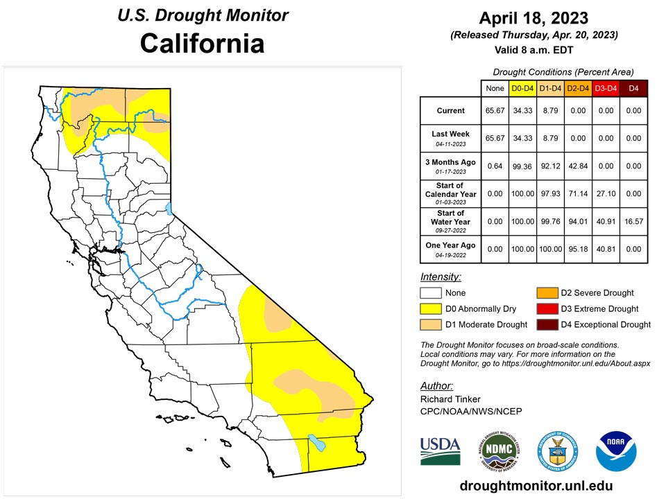
According to the California Department of Water Resources, mid-April statewide reservoir contents were about 19.5 million acre-feet in 2021, and less than 18 million acre-feet in 2022. But after abundant December-March precipitation in most of the state, mid-April reservoir storage has rebounded to around 27.5 million acre-feet this year, slightly above the long-term average of around 26 million acre-feet at this time of year.
Caribbean
Light to moderate rain across Puerto Rico kept dryness and moderate drought unchanged, although weekly totals topped 2 inches in parts of northwestern Puerto Rico.
Rainfall observations at St. John ranged from 0.32 inches from a CoCoRaHs observer to 0.54 inches at Windswept Beach. Short-term abnormal dryness continued this week, as groundwater levels have not seen a significant increase after a slow, steady decline, though short-term precipitation deficits have slightly improved. Rainfall observations from this week on St. Thomas ranged from 0.29 inches at Cyril E King Airport to 0.7 inches at a CoCoRaHs site on the west end of the island. Groundwater has recently been rebounding a little as well, though short-term moderate drought continued this week. Groundwater has remained in the same range recently, while rainfall observations on St. Croix this week were generally low (with the highest number coming in at 0.29 inches). Recent precipitation data suggests the west end of the island remains drier, with a wetter signal in the east. Severe short- and long-term drought continued this week.
Pacific
Alaska remained free of dryness and drought.
Several weeks of near or above normal rainfall has left the Big Island of Hawai’i free of any significant dryness. Drought (D1) is now restricted to part of northwestern Maui, and abnormal dryness covers the remainder of Maui, all of Kaho’Olawe, and south-central Moloka’i.
Dry conditions occurred this week on Palau, with 0.06 and 0.07 inches of rain being reported at observing sites there. While not yet at the level of abnormal dryness, conditions will continue to be monitored there.
American Samoa remained free of drought or abnormal dryness. Rainfall amounts this week ranged from 1.93 inches at Toa Ridge to 4.64 inches at Siufaga Ridge to 5.91 inches at Pago Pago.
No changes were made to the Drought Monitor in the Marshall Islands this week. Just over a half inch of rain fell in Kwajalein this week, where long-term moderate drought conditions continued. Jaluit and Wotje both saw over 3 inches of rain this week; however, given the preceding dryness at both locations, short-term abnormal dryness continued at Jaluit, and short- and long-term severe drought continued at Wotje. Ailinglapalap, Majuro and Mili saw wet conditions this week, with totals coming in at 4.43 inches, 5.09 inches and 3.94 inches, respectively. No data was available for Utirik, so no Drought Monitor analysis was done there.
Short-term abnormal dryness continued this week on Ulithi; no rain was reported, though three days in the analysis period were unaccounted for. The rest of the Federated States of Micronesia remained free of drought or abnormal dryness. Yap, Woleai, Chuuk, Lukunor and Fananu remained mostly dry this week, but recent wet weather kept them free of abnormal dryness. Kapingamarangi recorded 1.44 inches of rain this week, though this was on the heels of 9.87 inches last week. Nukuoro, Pohnpei and Pingelap all received at least 4 inches of rain this week. Kosrae received 2.1 inches of rain, following 5.17 inches last week.
The Mariana Islands remained free of drought and abnormal dryness this week. On Saipan, 0.68 inches of rain was recorded this week. On Rota, at least 1.88 inches of rain fell this week, with one day left unaccounted for. On Guam, 1.01 inches of rain was recorded.
Looking Ahead
During the next five days (April 19-24, 2023) moderate to heavy precipitation (over an inch) is expected in the Pacific Northwest, higher elevations in the central and northern Rockies, much of the eastern Great Plains, most of the Mississippi Valley and Great Lakes Region, the Appalachians, the Carolinas, the Middle Atlantic Region, and the Northeast. Totals of 1.5 to 3.0 inches is forecast for a broad area from the Mississippi/Ohio Rivers’ Confluence Region southward across the west side of the lower Mississippi Valley and the eastern half of Texas. In contrast, most areas from the west side of the Great Plains to the Pacific Coast (outside the higher elevations and areas west of the Cascades) are expecting light precipitation at best. Light amounts of precipitation (less than one-quarter inch) are also expected in Florida, Georgia, and some adjacent locales.
The Climate Prediction Center’s 6-10 day outlook (valid April 25-29) shows above-normal precipitation favored over the vast majority of the central and eastern contiguous states and Alaska. Odds are only marginally enhanced in most areas, but odds exceed 50 percent that amounts will be in the wettest one-third of the historical distribution in part of the South Atlantic States and in southeastern Alaska. Subnormal precipitation is more favored in most areas from the Rockies to the Pacific Ocean, with much of the northern Great Basin having at least a 50 percent chance for precipitation totals in the lowest one-third of the historical distribution. Enhanced chances for subnormal temperatures cover a large area from the Plains to the Middle Atlantic Region, especially across the northern Plains, upper Midwest, and upper Mississippi Valley. Colder than normal temperatures are also expected across most of Alaska outside southeastern areas. Warmer than normal weather is forecast for the southern Rockies, the Intermountain West, and West Coast, as well as across northern New England and locations across and near the Florida Peninsula.
Author(s):
Richard Tinker, NOAA/NWS/NCEP/CPC
Curtis Riganti, National Drought Mitigation Center
Dryness Categories
D0 Abnormally Dry—used for areas showing dryness but not yet in drought, or for areas recovering from drought.
Drought Intensity Categories
D1 Moderate Drought
D2 Severe Drought
D3 Extreme Drought
D4 Exceptional Drought
Drought or Dryness Types
S Short-term, typically less than 6 months (agriculture, grasslands)
L Long-term, typically more than 6 months (hydrology, ecology)
SL Area contains both short- and long-term impacts
Source: National Drought Mitigation Center

