


National Drought Summary for May 2, 2023
Summary
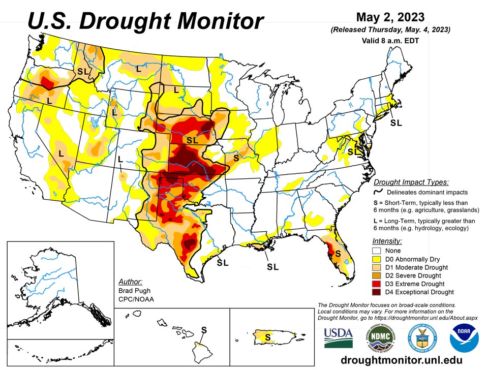
May 4, 2023 - A pair of low pressure systems tracked from the Southeast northward along the East Coast, bringing a swath of widespread precipitation (2 to 4 inches, locally more) to much of the East Coast at the end of April. During the final week of April, the Southern Great Plains along with the Lower Mississippi Valley also received widespread precipitation with amounts exceeding 2 inches across southeastern Colorado, northern and eastern Oklahoma, and northeastern Texas. Late April was mostly dry across the Central to Northern Great Plains and Middle Mississippi Valley. Little to no precipitation was observed throughout the West where a significant warmup at the end of April resulted in rapid snowmelt, runoff, and flooding along streams and rivers. In contrast to these above-normal temperatures, cooler-than-normal temperatures occurred across the Great Plains, Corn Belt, and much of the East from April 25 to May 1.
Northeast
Widespread 2 to 6 inches of rainfall resulted in a broad 1-category improvement across the Mid-Atlantic. A 2-category improvement (D1 to D-nada) was justified for north-central Maryland, northern New Jersey, southeastern Pennsylvania, and parts of Delaware which received more than 3 inches of rainfall, completely eliminating 60 to 90-day precipitation deficits and 28-day streamflows are near average. A small area of moderate drought (D1) remains in southern Maryland which received less than 1.5 inches of rainfall. D1 also continues for parts of southeastern New England with lower rainfall amounts this past week. Despite the widespread rainfall this past week across northern West Virginia, abnormal dryness (D0) continues due to low 28-day average streamflows, CPC’s leaky bucket soil moisture, and NDMC’s objective drought blends.
Southeast
Widespread 2 to 5 inches of rainfall led to a 1-category improvement to much of Virginia and northeastern North Carolina. A small area of moderate drought (D1) remains in western Virginia which missed out on the heavier amounts. 28-day average streamflows and CPC’s leaky bucket soil moisture support D1 in this area. Due to recent heavy rainfall, abnormal dryness (D0) coverage was decreased across southern Alabama and the Florida Panhandle. More than 2 inches of rainfall this past week resulted in a 1-category improvement to much of the Florida Peninsula and southeastern Georgia. 28-day streamflows still support extreme drought (D3) along the Nature Coast. Based on heavy rainfall amounts this past week and lack of support from multiple indicators, a 2-category improvement was justified for parts of southeastern Georgia and northeastern Florida. The addition of D0 in northern Alabama was based on increasing 30-day deficits, SPEI, soil moisture, and 28-day streamflows.
South
Balancing longer term SPIs and recent widespread rainfall (1 to 3.5 inches), a 1-category improvement was made to parts of Oklahoma and Texas. Improvements were also made to parts of central Texas along with the Texas Gulf Coast after more than 1.5 inches of rainfall this past week. CPC’s leaky bucket soil moisture and 90 to 120-day SPI supported a slight expansion of moderate (D1) to severe (D2) drought in west-central Texas. Based on soil moisture considerations and impact reports (very dry pastures), extreme (D3) drought was increased in coverage across the Texas Panhandle. The addition of abnormal dryness (D0) in east-central Tennessee was based on increasing 30-day deficits, SPEI, soil moisture, and 28-day average streamflows
Midwest
Based on increasing 30 to 60-day precipitation deficits, 30 to 60-day SPIs, and CPC's leaky bucket soil moisture, abnormal dryness (D0) and moderate drought (D1) was expanded across Iowa, Illinois, western Indiana, and Missouri. A swath of short-term severe drought (D2) was introduced to central Missouri where 60-day precipitation deficits exceed 4 inches and have support from soil moisture indicators for D2 intensity.
High Plains
Rainfall of 1.5 to 2 inches, or more, during the past week along with SPI at various time scales and soil moisture supported a 1 to 2-category improvement to southeastern Colorado. For similar reasons, a 1-category improvement was made to southwestern Kansas. However, 12-month SPI still supports D3-D4 across much of western and central KS. Wichita has only received 0.72 inches of precipitation from March 1 to April 30, which made it the 2nd driest March and April on record and the driest since 1936. Based on the NDMC's short and long-term objective blends and CPC's leaky bucket soil moisture, D1-D3 expansion was warranted for northern Kansas and south-central Nebraska. D3 was increased westward across west-central Nebraska following a very dry April. North Platte tied the driest April on record. Degradations were also made to southeastern Kansas based on 60 to 120-day SPEI. Abnormal dryness (D0) coverage increased in northeastern Wyoming based on recent dryness and declining soil moisture. A small improvement was made to the southwest corner of South Dakota, based on a local report that was consistent with VegDri and objective drought blends.
West
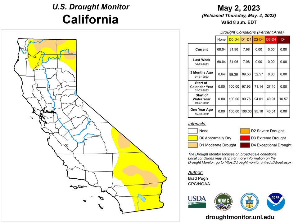
30 to 60-day SPI along with soil moisture indicators support an expansion of abnormal dryness (D0) and moderate drought (D1) across southeastern Montana. 30 to 90-day SPIs, recent warmth, and soil moisture led to a 1-category degradation in northwestern Montana. Following major improvements during the past few months across California and the Great Basin, no changes were made this week after little or no precipitation. Drought of varying intensity is designated for parts of Oregon and northern Idaho where precipitation averaged below-normal for the Water Year to Date (October 1, 2022 to May 1, 2023).
Caribbean
Heavy rainfall (more than 2 inches) this past week resulted in a reduction of moderate drought (D1) in western Puerto Rico. 28-day average streamflows are running close to average for most areas.
Spotty showers, totaling less than one-third of an inch at all official and CoCoRaHS volunteer reporting sites during the drought-monitoring period ending May 2, brought no change to the depiction for the U.S. Virgin Islands. Severe drought (D2-SL) persisted on St. Croix, highlighted by poor vegetation health and increasing depth to groundwater. In recent days, depth to water at the USGS Adventure 28 Well on St. Croix topped 30 feet, an increase of more than 5 feet since late-November 2022. Significant increases in depth to water were also observed between November 2022 and early-May 2023 at the USGS wells on St. Thomas (an increase of almost 12 feet) and St. John (approximately 8 feet). Moderate drought (D1-S) continued on St. Thomas, while abnormal dryness (D0-S) persisted on St. John.
Pacific
Alaska remained free of any abnormal dryness (D0).
Significant rainfall this past week resulted in the removal of abnormal dryness (D0) in Maui, but increasing short-term deficits caused an expansion of D0 and the addition of moderate drought (D1) to the northern Big Island.
Active weather prevailed across the U.S.-Affiliated Pacific Islands in late April and early May, except for generally tranquil conditions in the Marianas and the northwestern part of the Federated States of Micronesia (FSM). For the drought-monitoring period ending May 2, changes in the Republic of the Marshall Islands (RMI) included the removal of abnormal dryness (D0-L) for Kwajalein and an improvement from moderate drought to abnormally dry conditions (from D1-L to D0-L) for Wotje. During the 2 weeks ending May 2, rainfall for Kwajalein totaled 9.15 inches, while 3-week rainfall for Wotje topped 8 inches. Elsewhere in the RMI, Jaluit remained abnormally dry (D0-S), with only 0.87 inch occurring during the drought-monitoring period.
Meanwhile in the FSM, Ulithi remained abnormally dry (D0-S). Ulithi’s April rainfall of 3.22 inches supported the designation of abnormal dryness. Yap received 5.86 inches during April, but each of the last 3 weeks has featured rainfall totaling less than 1.25 inch. Given the incipient dry spell, Yap will be monitored in coming weeks. In the Marianas, a drying trend developed in mid- to late April, especially north of Guam. In Saipan, where barely an inch (1.05 inches) of rain fell during the 3 weeks ending May 2, developing dryness will be monitored. Finally, neither dryness nor drought existed across American Samoa and the Republic of Palau. During April, rainfall at Pago Pago International Airport in American Samoa totaled 14.25 inches.
Looking Ahead
During the next five days (May 4 - 8, 2023), moderate to heavy precipitation (0.5-1.5 inches, locally more) is forecast for the Pacific Northwest, Great Basin, Northern Rockies, and higher elevations of California. An active weather pattern is expected from the Great Plains east to the Mississippi Valley with varying 5-day precipitation amounts forecast. Following a very wet end to April along the East Coast, drier weather is forecast to be accompanied by a gradual warming trend across the East.
The Climate Prediction Center’s 6-10 day outlook (valid May 9-13) favors below-normal temperatures across the West, while above-normal temperatures are more likely throughout the central and eastern U.S. Elevated probabilities for above-normal precipitation are forecast for the Pacific Northwest, northern California, Great Plains, Mississippi Valley, and Southeast. Near normal precipitation amounts are favored for much of the Great Lakes and Northeast.
Author(s):
Brad Pugh, NOAA/CPC
Brad Rippey, U.S. Department of Agriculture
Dryness Categories
D0 Abnormally Dry—used for areas showing dryness but not yet in drought, or for areas recovering from drought.
Drought Intensity Categories
D1 Moderate Drought
D2 Severe Drought
D3 Extreme Drought
D4 Exceptional Drought
Drought or Dryness Types
S Short-term, typically less than 6 months (agriculture, grasslands)
L Long-term, typically more than 6 months (hydrology, ecology)
SL Area contains both short- and long-term impacts
Source: National Drought Mitigation Center

