


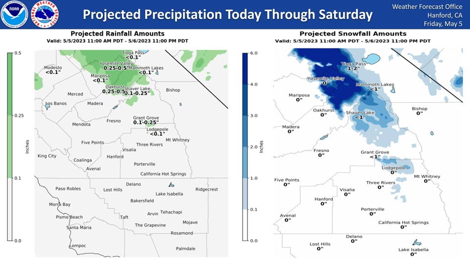
Projected Precipitation for Mariposa: Less than 0.10"
Projected Precipitation for Oakhurst and Yosemite Valley: 0.25" to 0.50"
May 5, 2023 - National Weather Service Hanford Office officials report a trough of low pressure will pass eastward over Northern California today through Saturday, resulting in isolated showers in the Sierra Nevada and adjacent foothills.
Snow levels will be around 5,000 feet.
The majority of this precipitation will fall Saturday afternoon.
Area Forecast Discussion
National Weather Service Hanford CA
215 AM PDT Fri May 5 2023
.SYNOPSIS...An upper level low will move slowly inland across
Central California today, keeping a chance of precipitation over
the mountains. Another system will bring unsettled conditions to
the area on Saturday. Temperatures will remain well below normal
through Saturday then a warming trend will take place on Sunday
and Monday. A weak system will bring slightly cooler temepratures
and mountain showers by Wednesday then a warming and drying trend
will take place later next week.
&&
.DISCUSSION...Upper low pressure system currently centered over
central CA maintaining unsettled showery conditions across our
area overnight. Mesowest is indicating the snow level is currently
running near 6000 feet. The low is progged to slowly move east
towards the Great Basin today which will keep a cool and unstable
airmass over our area with temperatures remaining well below
normal and continuing chances of mountain showers. Latest NBM
probabilistic guidance is indicating a 50 to 70 percent chance of
maximum temperatures below 70 DEG F across most of the San Joaquin
valley today.
SREF is indicating a shortwave system dropping into Norcal behind
the departing upper low on Saturday. This system might provide
enough moisture and dynamics for a chance of showers north of
Fresno County on Saturday. This shortwave system will act as a
kicker and help eject the large upper low out of the Great Basin
by Saturday night. Shortwave ridging follows on Sunday which will
allow for a warming and drying trend to take place across our
area. Another upper low will move inland near the Oregon border on
Monday and lift into the inland PAC NW. This will keep the
moisture and dynamics from this system well to the north of our
area and as a result the warming and drying trend will continue
across our area.
Medium range progs are showing a lot of spread amongst the
ensemble members. As a result, confidence is low for the medium
range period. Ensemble means are showing an upper trough swinging
through CA on Tuesday and Wednesday which will bring a slight
cooling trend and a chance of mountain showers. NBM indicating an
upper ridge will amplify just off the western CONUS coast by next
Thursday will provide for a more significant warming trend across
our area later next week.
&&
.AVIATION...In the Sierra Nevada and Tehachapi Mountains,
widespread MVFR with areas of mountain obscuring IFR in low clouds
and showers. Elsewhere, VFR conditions will prevail across the
Central CA interior for the next 24 hours.
&&
.AIR QUALITY ISSUES...None.
&&
.CERTAINTY...
The level of certainty for days 1 and 2 is low.
The level of certainty for days 3 through 7 is low.
Certainty levels include low...medium...and high. Please visit
www.weather.gov/hnx/certainty.html for additional information
and/or to provide feedback.
&&
.HNX WATCHES/WARNINGS/ADVISORIES...None.
Source: NWS

