


Includes Yosemite National Park
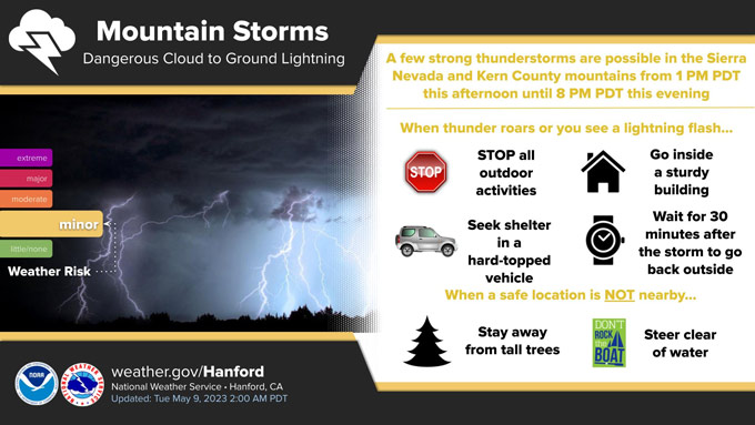
May 9, 2023 - National Weather Service Hanford Office officials report a few strong thunderstorms are possible in the Sierra Nevada and Kern County mountains from 1:00 P.M. this afternoon until 8:00 P.M. this evening.
Small hail and wind gusts near 45 miles per hour are a couple of hazards associated with strong thunderstorms.
In addition to dangerous cloud to ground lightning strikes, any thunderstorm can produce intense rainfall rates, leading to localized flooding.
Area Forecast Discussion
National Weather Service Hanford CA
323 AM PDT Tue May 9 2023
.SYNOPSIS...
A trough of low pressure will bring a low to moderate chance for
showers and a slight chance of thunderstorms across the mountains
late this afternoon through tonight. Strong wind gusts will develop
across the Mojave slopes and desert areas from this evening through
Wednesday morning. A warming trend will begin midweek with forecast
high temperatures around 15 degrees above average this weekend.
&&
.DISCUSSION...
A broad upper trough remains over the region with one short wave
lifting over the Pacific Northwest as another upstream short wave
approaches off the northern California coast. The disturbance will
track southeast to just along the central California coast by this
afternoon then move inland over southern California tonight before
shifting east over the Four Corners region on Wednesday. This will
provide a low to moderate chance for showers late this afternoon
through tonight, mainly across the mountains. Instability will be
sufficient for a slight chance of thunderstorms as well. QPF is up
to one quarter of an inch in the Sierra Nevada with up to 3 inches
of snow possible above 7000 feet. The Kern County mountains have a
little higher QPF with up to one half of an inch. Snow amounts up
to 6 inches are possible over some of the higher peaks above 7000
feet. Any thunderstorm that develops would be capable of producing
locally heavy rainfall along with small hail and gusty winds. The
trough will increase winds as well with strong gusts in the Mojave
Slopes and desert zones. A Wind Advisory has been issued for these
areas from 5 PM this afternoon through 11 AM Wednesday. Conditions
will be a little cooler today with high temperatures around 7 to
10 degrees below climatological averages for this time of the year.
Dry weather returns on Wednesday as East Pacific ridging begins to
build inland. Modest warming will occur initially with highs back
to near average by Thursday. By Friday, highs are forecast to be
around 3 to 7 degrees above average with upper 80s across much of
the San Joaquin Valley. More significant warming is forecast this
weekend with SJ Valley highs into the middle to upper 90s, around
15 degrees above average for the middle of May. Probabilities for
a high temperature of 95 degrees or higher in the SJ Valley range
from 60% to 80% on Sunday, May 14.
&&
.AVIATION...
Areas of MVFR and local mountain obscuring IFR conditions in low
clouds and showers over the Sierra Nevada and Tehachapi Mountains
from 00Z to 12Z Wednesday. VFR conditions will prevail elsewhere
across Central California for at least the next 24 hours.
&&
.AIR QUALITY ISSUES...
None.
&&
.CERTAINTY...
The level of certainty for days 1 and 2 is high.
The level of certainty for days 3 through 7 is medium.
Certainty levels include low...medium...and high. Please visit
www.weather.gov/hnx/certainty.html for additional information
and/or to provide feedback.
&&
.HNX WATCHES/WARNINGS/ADVISORIES...
Wind Advisory from 5 PM this afternoon to 11 AM PDT Wednesday
for CAZ337>339.
Source: NWS

