


California and National Drought Summary for May 9, 2023
Summary
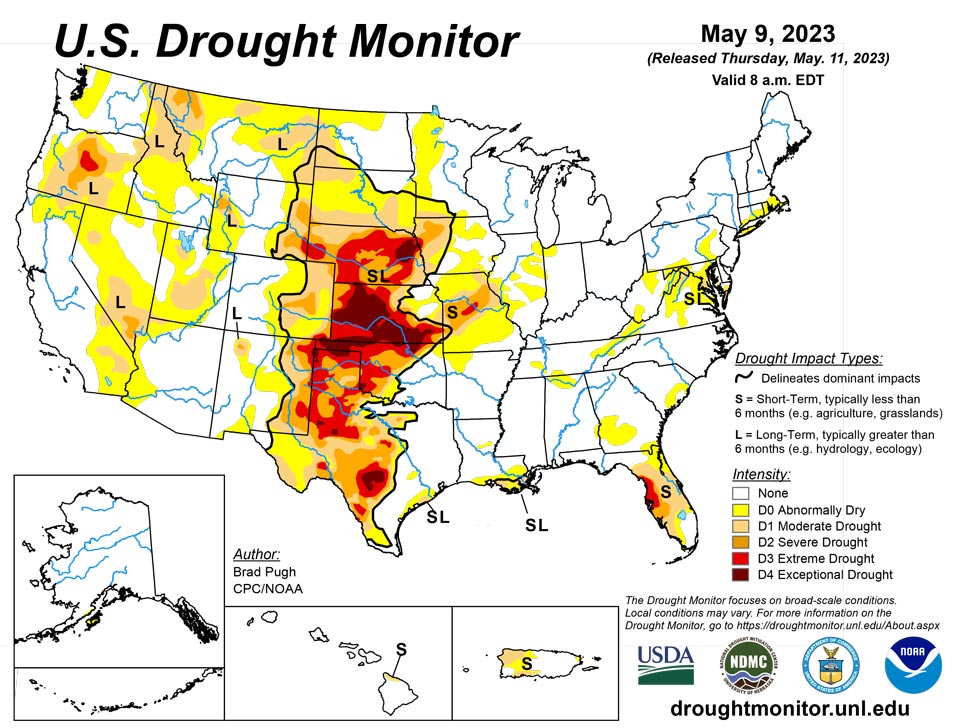
May 11, 2023 - A strong area of mid-level low pressure, near the West Coast, resulted in anomalously wet weather during the first week of May throughout the Pacific Northwest, Northern Rockies, Great Basin, and California. Scattered thunderstorms brought pockets of heavy rainfall (more than 2 inches), from May 2 to 8, to parts of Texas, central Nebraska, and the Midwest. However, much of Kansas, Missouri, and southern Nebraska missed out on this beneficial rainfall. Following a wet end to April across the East, drier weather prevailed this past week from the Mid-Atlantic south to Florida. 7-day temperatures, ending on May 8, averaged below-normal across most of the East along with California, the Great Basin, and Desert Southwest. Weekly temperatures averaged above-normal across the Great Plains.
Northeast
Along and to the west of the central Appalachians, rain and high-elevation snow (1.5 to 3 inches, liquid equivalent), fell across southwest Pennsylvania, western Maryland, and northern West Virginia at the beginning of May. This recent precipitation resulted in a decrease in abnormal dryness (D0) across northern West Virginia and western Maryland where USGS 28-day average streamflows are near normal. Although only light precipitation was observed across southeastern New England this past week, further analysis of various indicators supported a 1-category improvement for this region.
Southeast
Increasing short-term precipitation deficits along with soil moisture and USGS 28-day average streamflow indicators supported an expansion of abnormal dryness (D0) across northern Alabama. Conversely, recent rainfall and improving conditions led to the removal of D0 in southern Alabama and the western Florida Panhandle. D0 was added to parts of western Virginia, based on 30 to 60-day SPI and 28-day average streamflows. The D0 across South Carolina was modified to be more consistent with the 30 to 60-day SPI. Due to increasing short-term precipitation deficits, a slight expansion of D0 was made to southwestern Georgia. Further assessment after the heavy rainfall during late April resulted in the removal of moderate drought (D1) in northeastern Florida and slight improvements across parts of southern Florida. Extreme drought (D3) was expanded to include Pinellas and Hillsborough counties of Florida. Tampa has its driest start to the year since 2000 with only 3.67 inches of precipitation.
South
A mix of degradations and improvements were made this past week to the Southern Great Plains, western Gulf Coast, Lower Mississippi Valley, and Tennessee Valley. Severe drought (D2) was slightly expanded in southeast New Mexico, based on 90-day SPI and USGS 28-day average streamflows falling below the 10th percentile along parts of the Black River. Based on declining soil moisture indicators, extreme drought (D3) was expanded westward across the Edwards Plateau. More than 1.5 inches of rainfall this past week resulted in a 1-category improvement to parts of central and northwest Texas, the Texas Panhandle, and central Oklahoma. According to NDMC’s long-term objective drought blend, there remains a sharp gradient between extreme to exceptional drought (D3-D4) in northwest Oklahoma to anomalously wet conditions in southeast Oklahoma. An increase in abnormal dryness (D0) was warranted for parts of northwest Arkansas based on increasing 30-day precipitation deficits and 28-day average streamflows below the 30th percentile. The D0 coverage was modified across Tennessee after central parts of the state received more than 1.5 inches of rainfall. However, D0 was expanded to include more of western and northeastern Tennessee, based on 30 to 60-day SPI and 28-day average streamflows. Recent heavy rainfall and 120-day SPI supported elimination of D0 in coastal Mississippi and a slight D0 decrease in southeastern LA. Also, the coverage of moderate drought (D1) decreased across southeastern Louisiana. A small area of D0 was added to central Louisiana where 30 to 60-day precipitation deficits are increasing.
Midwest
A rapid expansion and intensification of short-term drought is ongoing throughout Missouri with much of the central and northern parts of the state receiving less than two inches of precipitation during the past 60 days when seasonal temperatures begin to warm. Based on 30 to 60-day SPI, NDMC’s short-term objective drought blend, and CPC soil moisture, a 1-category degradation was made to a majority of Missouri. The addition of extreme short-term drought (D3) to central Missouri was supported by 60-day SPI, CPC soil moisture, USGS 28-day average streamflow below the 5th percentile, and NDMC’s short-term drought blend. Locally heavy rainfall (1.5 to 2 inches, or more) in parts of southwest and northern Missouri resulted in no change from the previous week or small improvements. Farther to the north across central to southeastern Iowa, heavy rainfall (1.5 inches or more) led to a decrease in abnormal dryness (D0). The exceptional drought (D4) was removed from the southwest corner of Iowa due the lack of support from long-term indicators. D0 was reduced across parts of Illinois and adjacent Indiana where rainfall amounts exceeded 1.5 inches this past week. A slight D0 expansion was necessary near Lake Michigan where less than 0.5 inch of rainfall was observed. Based on improving long-term indicators, D0 was reduced across northern Minnesota. Increasing short-term precipitation deficits led to a slight expansion of moderate drought (D1) for southwestern Minnesota. Although there are increasing 30 to 60-day precipitation deficits across eastern Kentucky, the consensus of indicators supports no addition of D0 at this time.
High Plains
Convective rainfall, typical for early May, occurred this past week across parts of Kansas and Nebraska. In areas such as central Nebraska, that received more than 2 inches of rainfall and there was a lack of support from SPI at various time scales and NDMC’s objective drought blends, a 1-category improvement was made. However, in areas that missed out on this rainfall, a 1-category degradation was necessary for parts of southern Nebraska and central to eastern Kansas. According to the U.S. Department of Agriculture, 64 and 68 percent of the pastures and ranges for Kansas and Nebraska, respectively, are rated poor to very poor. Abnormal dryness (D0) was expanded westward near and along the Colorado Rockies based on SPIs at various time scales, while an increase in severe drought (D2) coverage was justified for parts of the High Plains of eastern Colorado that missed out on the recent heavier precipitation. Based on multiple indicators including Condition Monitoring Observer Reports, abnormal dryness (D0) was reduced across northern parts of North Dakota.
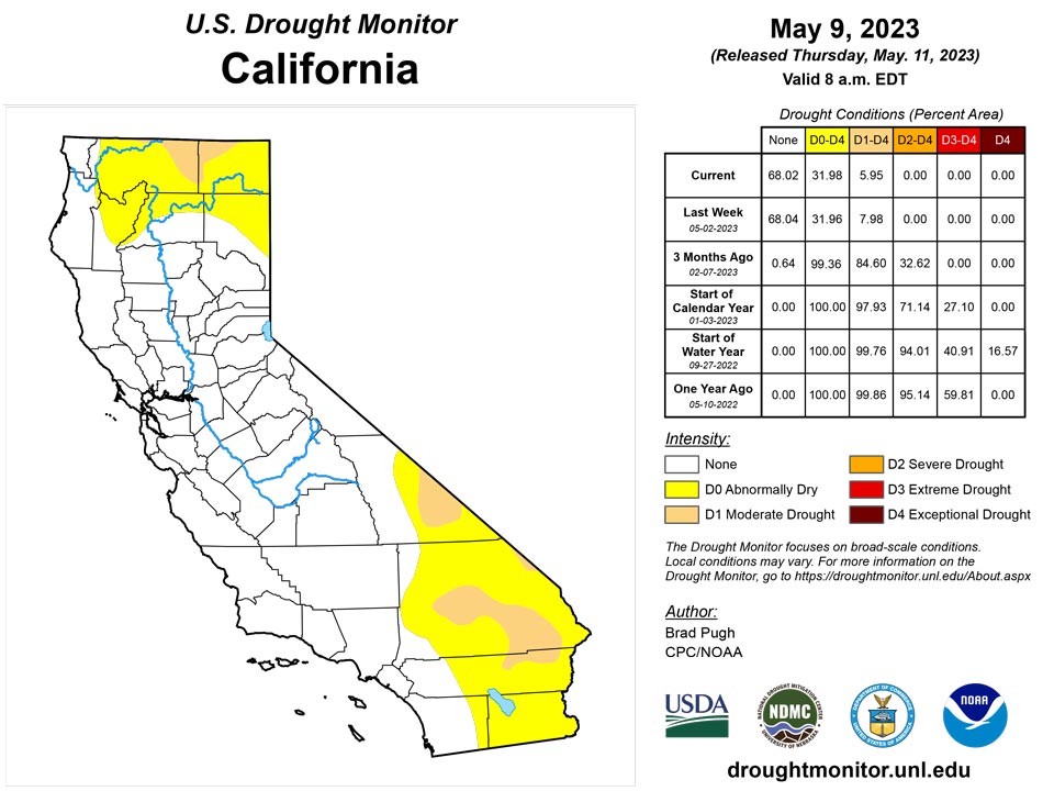
West
Anomalously wet, cool weather prevailed across the West at the beginning of May. A 1-category improvement was made to parts of northern California after the wet start to the month and this improvement was also consistent with 24-month SPI, NDMC's long-term drought blend, and NASA's GRACE groundwater. It should be noted that Trinity reservoir in northern California remains at half of its historical average. A 1-category improvement was also warranted for parts of Oregon based on 24-month SPI, GRACE 1-meter soil moisture, and the wet first week of May. A decrease in abnormal dryness (D0) across parts of Washington was supported by SPI at multiple time scales, 28-day streamflow, and GRACE soil moisture. Based on 60-day SPI and longer time scales, moderate drought (D1) was reduced in coverage across southwestern Wyoming. D1 was changed to long-term abnormal dryness (D0) in northeast Montana based on SPI at multiple time scales and a favorable soil moisture response this spring down to 20 inches. Severe drought (D2) was removed from central Utah due to a lack of support from long-term indicators.
Caribbean
Increasing precipitation deficits and growing concern of levels on the Guajataca reservoir led to an expansion of moderate drought (D1) across northwestern Puerto Rico.
Weather in the U.S. Virgin Islands this week remained relatively dry. Groundwater levels at USGS well monitoring sites on all three islands continued to decline slightly this week. On St. Thomas, the Anna’s Retreat rainfall measuring site recorded 0.41 inches of rain. Otherwise, 0.09 and 0.12 inches of rain fell at sites on St. John, and generally paltry rain amounts also fell across St. Croix. Short-term precipitation statistics have worsened on St. John enough to degrade conditions there from short-term abnormal dryness to short-term moderate drought. No changes were made on St. Thomas, though given the dry weather there over the last several months, drought conditions may worsen there in the next few weeks if heavier rains do not return soon.
Pacific
Abnormal dryness (DO) was added to Kodiak Island based on below-normal precipitation during February-March-April (FMA). Kodiak airport had only 42 percent of its normal precipitation during FMA and had its driest FMA since 1972.
No changes were made to Hawaii this past week. The northeast side of the Big Island, currently designated with abnormal dryness (D0) and moderate drought (D1), received only light amounts of rainfall. Streamflows and impact reports continue to support this drought designation.
Palau IAP reported 3.46 inches of rain this week, and conditions remained free of drought or abnormal dryness.
After a relatively dry week at Pago Pago, with only 0.80 inches of rain, higher amounts returned this week, with 2.96 inches falling. Given this, conditions remained free of drought or abnormal dryness.
Rainfall on Yap this week reached 1.19 inches, with one day unaccounted for. Conditions there have not quite reached the level of abnormal dryness, but this marks the fourth consecutive week with less than 2 inches of rain. Short-term abnormal dryness continued on Ulithi, where 2.26 inches of rain were reported, marking the first week with at least 2 inches of rain since late March. No data were reported from Woleai this week, so no Drought Monitor depiction was made. However, given recent wet weeks, conditions should not be abnormally dry there. Fananu reported 2.29 inches of rain in one day this week, with the other six days missing. There is no abnormal dryness there based on recent data, but with the lack of data this week, a “no data” depiction is being made there. Chuuk, Nukuoro and Kapingamarangi all saw at least 3 inches of rain this week, and no abnormal dryness existed at those locations. Lukunor did not report data this week; the previous three weeks each had less than 2 inches of rain, though with some missing data. While it is possible that dryness has fallen into the abnormally dry category here, the available data was insufficient for determining that. Kosrae, Pohnpei and Pingelap received 2.04, 4.54 and 5.07 inches of rain this week, respectively, and conditions on each island remained free of abnormal dryness or drought.
Over 11 inches of rain fell on Kwajalein this week, with four days missing from the analysis period, and conditions remained free of drought or abnormal dryness. Ailinglapalap also had a wet week, with 6.8 inches of rain. Short-term abnormal dryness continued on Jaluit, though 3.54 inches of rain this week probably improved conditions a bit there. Conditions improved to normal this week on Wotje, where 3.73 inches of rain fell, marking the fourth consecutive week with over 2 inches of rainfall. Mili and Majuro received 4.52 and 5.26 inches of rain, respectively. No data was reported for Utirik, so no Drought Monitor depiction was made there.
Saipan recorded 0.18 inches of rain at the international airport this week, which extended their streak of weeks with less than an inch of rain to five. Due to the continuation of the dry stretch of weather, short-term abnormal dryness was introduced there this week. Rota received 2.27 inches of rain from April 18-24, which is keeping short-term abnormal dryness at bay. Only 0.16 inches of rain fell there this week, after 0.72 inches last week and 0.04 inches three weeks ago. At Guam, similar conditions are occurring to those on Rota. Rainfall this week came in at only 0.17 inches, following 0.78 inches last week. Rainfall amounts reached 1.81 inches there a couple weeks ago, which is keeping any abnormal dryness from developing for now.
Looking Ahead
During the next five days (May 11 - 15, 2023), widespread moderate to heavy rainfall (1 to 5 inches, locally more) is forecast across the Great Plains with the heaviest amounts expected to occur from southwestern Oklahoma south to the Middle Rio Grande Valley. Lighter amounts are predicted for southeastern Nebraska, northeastern Kansas, and the Middle Mississippi Valley. Rainfall amounts are expected to vary throughout the Midwest and Southeast, while the Northeast remains mostly dry. Compared to the start of May, much drier weather is forecast for the West.
The Climate Prediction Center’s 6-10 day outlook (valid May 16-20) depicts a highly amplified pattern with anomalous mid-level high pressure over the Northwest. Therefore, large probabilities for above-normal temperatures are forecast throughout the West. Associated with a wetter pattern likely for the south-central U.S. during mid-May, below-normal temperatures are favored for the Southern Great Plains and Lower Mississippi Valley. Below-normal temperatures are also favored across the Great Lakes, Eastern Corn Belt, and Northeast, while above-normal temperatures are more likely across the Southeast. Above-normal precipitation is favored across the southern tier of the U.S. with the largest probabilities forecast for the Southwest which is typically dry during this time of year. Elevated probabilities for below-normal precipitation are forecast across the Northern to Central Great Plains, Upper to Middle Mississippi Valley, and Corn Belt.
Author(s):
Brad Pugh, NOAA/CPC
Curtis Riganti, National Drought Mitigation Center
Dryness Categories
D0 Abnormally Dry—used for areas showing dryness but not yet in drought, or for areas recovering from drought.
Drought Intensity Categories
D1 Moderate Drought
D2 Severe Drought
D3 Extreme Drought
D4 Exceptional Drought
Drought or Dryness Types
S Short-term, typically less than 6 months (agriculture, grasslands)
L Long-term, typically more than 6 months (hydrology, ecology)
SL Area contains both short- and long-term impacts
Source: National Drought Mitigation Center

