


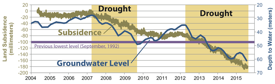
This graph shows land subsidence at a GPS station in the Central Valley, and also changes in groundwater levels at a nearby well.
October 6, 2015 - SAN DIEGO, Calif. – This year, groundwater levels in many wells in California’s Central Valley are at or below historical low levels. In addition, from 2007 through 2015, land subsidence that correlates to areas with large groundwater level declines has strongly increased in two large agricultural areas near the towns of El Nido and Pixley, according to a new article by the U.S. Geological Survey.
A new USGS website, launched in conjunction with the article's release, provides extensive additional information about groundwater-level declines and subsidence in the Central Valley.
During drought, surface water is less available, so people rely more heavily on groundwater. The extensive withdrawal of groundwater caused water levels to decline, according to the article, “Water Availability and Subsidence in California's Central Valley.” The California Department of Water Resources estimated that spring groundwater levels in 52 percent of the long-term wells (1,934 of 3,723) in the Central Valley are at or below the historical spring low levels in 2015.
The water-level declines are particularly evident in the southern two-thirds of the Central Valley, also known as the San Joaquin Valley, where recent water-level declines have been tied to land subsidence. This land subsidence is a sinking of the Earth’s surface due to pumping of groundwater from aquifer systems. In the Central Valley, subsidence has caused costly infrastructure damage such as canal buckling and reduced freeboard on canals and bridges. At some points, up to 11 inches of land subsidence was measured from 2012 to present.
“The Central Valley has many areas where recent groundwater levels are more than 100 feet below previous historical lows,” said Michelle Sneed, USGS hydrologist. “These correspond to areas of recent active subsidence.”
The article describes recent changes in water availability and, the competition for water in the Central Valley and evaluates how climate variability and human action influence subsidence, particularly during drought. Since the early 1990s, the availability of surface water has decreased because of operational changes of the federal Central Valley Project and the California State Water Project. Although irrigation has become more efficient, land use in the Central Valley has trended toward the planting of permanent crops, replacing non-permanent annual crops and rangeland.
“As land use, managed aquifer recharge and surface-water availability continue to vary, long-term groundwater-level and land-subsidence monitoring and modeling are critical to understanding the dynamics of the integrated system,” said Claudia Faunt, USGS hydrologist.
To assist water managers, the USGS has developed a computer simulation model of the Central Valley that accounts for variable water supply and demand for municipalities and irrigated agriculture, and simulates surface-water and groundwater flow, land subsidence, and other key processes on a monthly basis across the entire Central Valley. This model can be used to evaluate management strategies to mitigate adverse effects from subsidence while also optimizing water availability.
The article was published in San Francisco Estuary & Watershed Science. To learn more, visit the USGS science in the California’s Central Valley website.
Source: USGS
