


California and National Drought Summary for November 17, 2015
Summary
Three strong low pressure systems in the upper atmosphere moved across the Lower 48 States (CONUS) this U.S. Drought Monitor (USDM) week. Associated surface lows and fronts generated large areas of precipitation across the Plains to Midwest, Northeast, and parts of the West. Thunderstorms with heavy rains brought additional drought relief to areas from northeast Texas to southeast Minnesota and the Mid-Mississippi Valley. Several days of onshore flow wrung out abundant Pacific moisture along the coasts of Washington and northwestern Oregon, causing contraction of drought west of the Cascades. Only a few drought and abnormally dry areas in the Northeast received enough precipitation to warrant improvement. The precipitation largely missed areas from northwestern Utah to North Dakota. The Southeast was mostly drier than normal, except for southern Florida which saw both improvement and deterioration of drought.Alaska, Hawaii, and Puerto Rico
In Puerto Rico, only a few stations in the east reached or exceeded one inch of precipitation this week. With most stations reporting less than half an inch of rain, most of the island was drier than normal for the week. With most USGS stream gauges (except those in the extreme northeast of the island) at normal levels from the previous weeks' rains, no change was made to the USDM depiction for Puerto Rico.In Alaska, the panhandle stations were wetter than normal this week, but most of the rest of the state was drier than normal. Considering that most of the state (except the southern coastal areas) was below freezing this week, the D0 is frozen in place, so no change was made to the USDM depiction.
Rain fell across the Hawaiian Islands this week, with a mixed precipitation anomaly pattern resulting. The current moisture situation is adequately described by the D0 areas that were added last week, so no change was made to the USDM depiction in Hawaii this week.
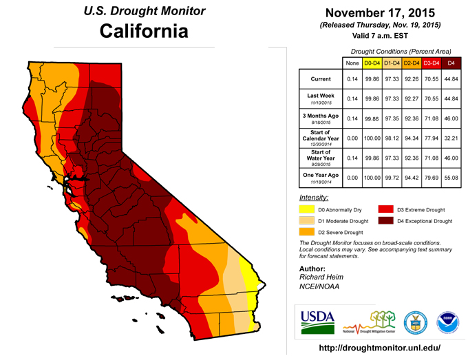
California and Great Basin
The northern coast of California and the Sierra Nevada received half an inch to an inch of precipitation this week from Pacific systems, with California’s Central Valley and portions of western and northeast Nevada receiving 0.25 to 0.50 inch of moisture. This was enough to increase snowpack a few inches at some SNOTEL stations in the Sierra and northeast Nevada. While the precipitation was beneficial to surface soil moisture, it had no effect on the long-term hydrological situation. In some areas, river base flows have not increased and groundwater and reservoir levels have not rebounded. Additionally, a well recently went dry in Cazadero (Sonoma County) in one of the typically more wet environments of northern California (coastal redwood forest). According to media reports, as of November 12, of 125 recreational lakes in California, 33 lakes held less than 25 percent of capacity, 19 of the 33 lakes held less than 10 percent of capacity and four lakes were empty. As noted by the U.S. Department of Agriculture, California statewide reservoir statistics (from the California Department of Water Resources/CDEC), updated through the end of October, show that this year’s preliminary reservoir withdrawal stands at 6.92 million acre-feet (from a peak of 18.08 maf on March 31 to a probable minimum of 11.16 maf on October 31). This is just 84% of the historical average. Conservation is working, but storage is still precariously low, at second-lowest on record for this time of year, ahead of only 7.53 maf on October 31, 1977. In northeast Nevada, D1 was pulled back in southern Elko County and D2 was sliced and pulled back in Elko and White Pine counties to reflect improved moisture conditions for the last several weeks to 2 years. But no changes were made to the map depiction for the rest of Nevada or California.Great Plains to Mississippi Valley
A front at the beginning of this USDM week brought precipitation to the central Plains to northern Mississippi Valley, and a slow-moving system at the end of the week drenched parts of the southern and central Plains to Mid-Mississippi Valley. A large part of the southern to central Plains and Mississippi Valley received half an inch or more of precipitation. A band of 1.5 to 2+ inches stretched across northwest Iowa, southeast Minnesota, and northwest Wisconsin. D0 was pulled back from Dodge County in southeast Minnesota; otherwise, the precipitation largely missed the drought and abnormally dry areas in the northern parts of this region.Rains with the system at the end of the week fell where they were needed. Fueled with Gulf of Mexico moisture, the weather system dropped an inch or more of rain across northeast Texas, central to eastern Oklahoma, eastern Kansas, southern Illinois, and much of Missouri and Arkansas. Parts of Oklahoma, Missouri, Arkansas, and the area around the confluence of the Mississippi and Ohio Rivers received over 2 inches of rain. D0 and D1 were trimmed or deleted in northeast Texas, eastern Oklahoma and Kansas, western Kentucky and Tennessee, and much of Arkansas, Missouri, and Illinois. Areas of D0 and D1 were left where the rains were not as intense or were not enough to erase precipitation deficits that stretched back 2 months or more.
Ohio Valley to Great Lakes region
western parts of the region received half an inch to an inch of precipitation, while northern parts of Michigan had 1 to 2 inches. The rest of the region had less than half an inch. The precipitation was enough to prevent expansion of drought and abnormal dryness, but not enough to cause any contraction or elimination.Pacific Northwest and Northern Rockies
Most days this week saw a continuation of the barrage of Pacific moisture and storm systems into Washington and northern Oregon. The frontal rains and upslope enhancement wrung out 6+ inches of precipitation over a widespread area west of the Cascades. Precipitation totals for November 11-17 from CoCoRaHS stations in Washington included 20.79 inches at Quinault, 14.31 inches at Elma, and 13.03 inches at Olympia. Several other stations in western Washington reported over 8 inches of precipitation. Normals here this time of year can range up to 3 to 5 inches a week, so the precipitation that fell was 2 to 4 times the weekly normal. The rainfall raised streamflows and increased soil moisture, with some high elevation SNOTEL stations recording an increase of snowpack, up to 1 to 2 feet of new snow at some stations. D1 was pulled back across much of western Washington and northwest Oregon west of the Cascades, and D2 was deleted northwest of Seattle and pulled back along the west slopes of the Cascades in northern Washington. D0 remained west of the Cascades to reflect the continued low reservoir levels. In Oregon, long-term precipitation deficits remained even with these last few storms, streamflows have been slow to respond, and reservoirs were near empty (the Willamette is well into conservation storage). It will take many more storms, with the accumulation of a thick winter mountain snowpack, to refill the reservoirs during the spring melt season.With a westerly circulation, the air masses dried out as the crested the Cascades, so central and eastern portions of Washington and Oregon received only a few tenths of an inch of precipitation at best. Parts of the Rockies in northern Idaho and northwest Montana received half an inch or more of precipitation, which helped increase the snowpack at some high-elevation SNOTEL stations, but snow depth reports were only a few inches to a foot at most SNOTEL stations. Precipitation amounts declined to the east and south, with parts of northern Wyoming and southeast Montana receiving less than a tenth of an inch or no moisture. D0 expanded in northeast Wyoming and southeast, south central, and central Montana to better reflect dryness at the 7 to 120 day time scales.
Southeast
Much of the Southeast received little to no precipitation this week. D0 expanded in northwest Alabama to adjacent counties in south central Tennessee, and in southeast Georgia, where notable precipitation deficits existed over the last two months. An exception to the dryness was in southern Florida. Rainfall totals of 2-3 inches along coastal Broward, Dade, and Monroe counties resulted in contraction of D0, but low flows and high salinity levels from Taylor slough to Florida Bay prompted the expansion of D1.Southwest
Half an inch to an inch of precipitation fell across large parts of the Four Corners States, with parts of Colorado measuring 1 to 2 inches. Most of the high-elevation SNOTEL stations in the Southwest recorded increases in snow depth, but this is early in the snow season. In Colorado, widespread precipitation over the last week, and wet SPI (Standardized Precipitation Index) values to the last 60 days, resulted in the trimming of the D0 in the central part of the state, with D0 remaining in the region to reflect dryness at longer time scales. In New Mexico, the SPEI (Standardized Precipitation Evapotranspiration Index, another important drought index) indicated lingering dryness at long time scales, from 48 to 72 months, but moisture conditions were much improved for the last one to 36 months. A November 15 USDA report says most winter wheat fields were reported to have excellent grazing available for cattle that were being overwintered on small grains, but topsoil moisture is 48% short to very short and subsoil moisture is 33% short to very short, statewide. The D1 in San Juan and McKinley counties in northwest New Mexico was trimmed to reflect the improved moisture conditions, but D0 and the rest of the D1 were kept to reflect continued low reservoirs which likely will take years to recover. No change was made to the USDM depiction across the rest of the Southwest.The Northeast
A weather system early in the period dropped moderate (1-2 inches) to locally heavy (2+ inches) rain on parts of the Northeast, with much of the region receiving half an inch of precipitation. The heaviest rains missed most of the drought and abnormally dry areas, except D0 was removed from Broome County, New York to Susquehanna County, Pennsylvania, where 2+ inches of rain erased deficits out to 60 days. Parts of New England missed out on the precipitation. D0 was added to parts of northern New Hampshire, northern Vermont, and adjacent Maine, where streamflow was low. Above-normal wildfire activity was reported in New Hampshire. D0 was expanded up the Lake Champlain Valley along the New York-Vermont border where precipitation was below normal this week and deficits show up at longer time scales to 120 days; this expanded D0 joined with the D0 in Clinton County. Milford, Massachusetts remained in a Stage IV Total Mandatory Water Conservation Alert, which took effect on October 23, due to Echo Lake reservoir holding just 65 percent of capacity, its lowest level since January 2015; this area of Massachusetts was already in D1, so no change was made to the map there.Looking Ahead
As the current USDM week came to a close, a strong cold front was moving across the Plains towards the Mississippi Valley. Several inches of rain had already fallen from eastern Texas to Mississippi and northward to Missouri and Illinois during the first day of the period for the November 24 USDM. For the upcoming 5 days (November 18-23), which will fill out the November 24 USDM week, the front and low pressure system will drop one inch or more of precipitation across the Southeast to Mid-Atlantic States and parts of the Great Lakes and Northeast. Two inches or more of rain are predicted for parts of Alabama to the Southern Appalachians. A band of precipitation is forecast from the Upper Mississippi Valley, across the Central Plains and Wyoming, to the Pacific Northwest, with amounts ranging generally from a tenth to half an inch, but locally to an inch or more, especially in western Oregon. No precipitation is predicted for most of California to the Southern Plains, or along the Canadian border from Washington to North Dakota. Temperatures are forecast to be below normal, except for parts of the Southwest, Southeast, and Northeast.For the ensuing 5 days (November 24-28), the odds favor below median precipitation in the Pacific Northwest and along the entire East Coast of the CONUS. With a southerly flow out of the Gulf of Mexico, above-median precipitation is expected across the rest of the country, especially across the southern and central Plains to Midwest. Below-normal temperatures are expected across most of the West and into the northern Plains, with above-normal temperatures from New Mexico to the Great Lakes and eastward, except for near-normal temperatures in the Southeast. For Alaska, the odds favor below-normal temperatures and below-median precipitation for the panhandle, with above-normal temperatures and above-median precipitation for the rest of the state.
Author(s):
Richard Heim, NOAA/NCEI
Dryness Categories
D0 ... Abnormally Dry ... used for areas showing dryness but not yet in drought, or for areas recovering from drought.Drought Intensity Categories
D1 ... Moderate DroughtD2 ... Severe Drought
D3 ... Extreme Drought
D4 ... Exceptional Drought
Drought or Dryness Types
S ... Short-Term, typically <6 months (e.g. agricultural, grasslands)L ... Long-Term, typically >6 months (e.g. hydrology, ecology)
Source: National Drought Mitigation Center
