


California and National Drought Summary for November 24, 2015
Summary
A strong upper-level low pressure system funneled Gulf of Mexico moisture into the central U.S. at the beginning of this USDM week, triggering widespread heavy rains and severe weather. Two to 5 inches of rain fell on November 17 from eastern Texas to Missouri eastward to Mississippi and Illinois. An inch or more of precipitation was observed from northwest Kansas to central Nebraska, across Iowa and Minnesota, and into the western Great Lakes. As the Low and cold front moved eastward on the next day, 1 to locally 3+ inches of precipitation fell across the Southeast, Tennessee Valley, and Upper Mississippi Valley. By the third day, the system had dropped an inch or more of precipitation along the East Coast. Meanwhile, another storm system brought rain and snow to the Pacific Northwest, with 1 to 3+ inches, and locally up to 5 inches, of precipitation measured in Washington and northwest Oregon west of the Cascades. Another system moved from the Pacific Northwest, across the Plains to the southern Great Lakes, leaving a blanket of snow in its wake, up to a foot or more deep in places. As a result, drought and abnormal dryness contracted over large parts of the country. The weather systems missed the Southwest and northern Plains. Virtually no precipitation fell across California to parts of Colorado, New Mexico, and Texas, with a tenth of an inch or less widespread across the northern Plains. Temperatures averaged warmer than normal across much of the East to northern Plains, and in parts of the central Plains and Far West. Cooler-than-normal temperatures dominated from the Pacific Northwest and Northern Rockies to the southern Plains.Alaska, Hawaii, and Puerto Rico
As the current USDM week came to a close, an upper-level low pressure system was poised to generate rain and snow over a large part of the West. The system will slowly move to the east during the next 5 days (November 25-29), bringing heavy precipitation, once again, to parts of the Plains and Mississippi Valley. Most of the Lower 48 States can expect at least a tenth of an inch of precipitation, with the southern Plains to Ohio Valley receiving one to as much as 8 inches. Parts of the West can expect up to an inch of welcomed and much-needed precipitation. Parts of the Southwest, northern Plains, and Southeast will see the least precipitation. Temperatures are expected to be below normal in the West beneath the upper Low, and above normal east of the Rockies in the southerly flow of warm and humid Gulf of Mexico moisture.California and Great Basin
Half an inch to an inch of precipitation fell across eastern and northern parts of Colorado, with a few tenths in northern Utah and northeast New Mexico. But other than that, most of the Southwest received no precipitation this week. D0 was trimmed in northeast Colorado, where precipitation improved Standardized Precipitation Index values at several time scales. No change was made to the drought depiction in the rest of the region.Great Plains to Mississippi Valley
This week saw a continuation of widespread heavy rains across much of the eastern Great Plains and Mississippi Valley. An inch or more of rain fell from the eastern portions of the Plains states – from Texas to the Dakotas – eastward to the Mississippi Valley and beyond. A band of 1-inch precipitation stretched from northwest Kansas into central Nebraska. Two inches to locally 5+ inches was observed from eastern Texas and Oklahoma to Mississippi, western Tennessee, and Illinois. Two-plus inches of precipitation were measured across parts of South Dakota, Iowa, and Minnesota. This heavy precipitation effectively erased the D0 and D1 that remained from last week’s rains across southern and eastern portions of the region. D0 was removed from eastern Texas and southeastern Oklahoma. The rain in southeast Oklahoma contributed to Broken Bow and Hugo Lakes returning to near- to above-normal pool stage. D0-D1 disappeared from Arkansas and Mississippi, with only a small sliver of D0 remaining in northeast Mississippi to reflect longer-term precipitation deficits. D0 was removed from Missouri, southeast Iowa, southwest Tennessee, most of Illinois, and the confluence of the Ohio and Mississippi Rivers area. The recent rains in Illinois have restored soil moisture and benefited winter wheat. D1 was removed and D0 shrunk in Minnesota and Iowa. Heavy snow sliced away at the D0 in northwest Kansas, southwest Nebraska, and northeast Colorado. At the other end of the state, precipitation eroded D0 and deleted D1 in southeast Nebraska and northeast Kansas.In the northern Plains where precipitation was sparse this week, D0 expanded in southwest North Dakota and adjacent South Dakota. Below-normal precipitation for the last 7-90 days, coupled with windy and warmer-than-normal weather in recent weeks, continued to dry soils, with 23% of the topsoil and 28% of the subsoil moisture short or very short in North Dakota. In Wyoming, the storm system that blew through this week increased snow depth 4-12 inches at SNOTEL stations in the Big Horns. But even with this increase, snow depth was still less than a foot in this region, and snow water content and water year-to-date precipitation still ranked in the lowest 20th percentile to driest fifth percentile, so no change was made to the D0 in northeast Wyoming. November 22 USDA reports rated 44% of the topsoil and 46% of the subsoil in Wyoming short or very short of moisture. With low streamflows and precipitation deficits stretching over the last 2-12 months and longer, the drought impacts designator for the D0 and D1 in Kansas and north central Oklahoma was changed to SL to indicate both short- and long-term drought conditions.
Ohio Valley to Great Lakes region
Most of the region received half an inch to an inch of precipitation, while the southern and western portions had up to 2 inches or more. Less than half an inch of precipitation fell across eastern Ohio and the eastern Great Lakes. Improvements made to the western areas were discussed in the Mississippi Valley section. No change was made to the D0-D1 in Michigan, Indiana, or Ohio. November 22 USDA reports indicated that 31% of the subsoil and 24% of the topsoil was short or very short of moisture in Indiana, with the values at 25% for subsoil and 20% for topsoil in Ohio.Pacific Northwest and Northern Rockies
Another round of precipitation in coastal Washington and northwest Oregon resulted in improvement to the drought depiction. Two to 5 inches, and locally more, this week added to the precipitation of last week to bring two-week totals to 15-20 inches, or more, in favored upslope areas. Streams were bank full and flooding in many areas west of the Cascade ridge line, especially in Washington. It should be noted that instantaneous streamflow observations are an important flash flood monitoring indicator, but they should never be used for drought monitoring; the base streamflow is best used for drought monitoring, and that is estimated by averaging over several days. The persistent heavy rains and swollen rivers in Washington improved reservoir levels. Seattle-Everett-Tacoma deactivated their water shortage response plans November 23 due to improving reservoirs.Precipitation along and west of the Cascade Mountains was above normal for the last 7 to 90 days, and in some places above normal out to the last 12 months. The precipitation resulted in pullback of the D0 to the Cascade ridge line in Washington and contraction of D1-D3 in areas further north, and pullback of D0-D2 in northwest Oregon. But the weather systems producing this precipitation were embedded in a westerly flow, and areas in the rainshadow east of the Cascades continued to have below-normal precipitation at all time scales from the last 7 days to the last 36 months, so D2-D3 continued for Washington and Oregon east of the Cascades. The USGS 7-day, 14-day, and 28-day streamflow indicators show low streamflow in eastern Washington. According to the Bureau of Reclamation, November 22 reservoir statistics still showed low reservoir levels in the Yakima River Basin east of the Cascades, including Kachess and Cle Elum at 33% full each and Rimrock at 29% full. Kachess and Rimrock were well below average, even after the November precipitation. NRCS reservoir statistics are available on a monthly basis. The NRCS October 31 values for reservoirs east of the Cascade ridge line ranged from 30 to 70 percent of average and included 32% at Cle Elum Reservoir, 39% at Keechelus, 56% at Lake Shannon, 71% at Ross, 77% at Kachess, and 79% at Upper Baker.
Winter mountain snowpack is crucial to spring and summer water supplies. The Pacific Northwest experienced an abysmally low snowpack during the 2014-2015 snow season. The 2015-2016 snow season has started out with snowpack below average. In Washington, a handful of SNOTEL stations have 3 to 5 feet of snow in the northern Cascades, but most of the SNOTEL stations in the Cascades of Washington and Oregon had less than a foot of snow, even after the recent storm systems, and these are all at high elevations. This is still early in the snow season, but these values are less than 75% of normal, and in many cases less than 50% of normal. Snow depths ranged up to 2 feet in some of the higher SNOTEL stations in the northern Rockies of Idaho, but even many of these were still below normal for this time of year.
November 22 USDA reports noted that 18% of the winter wheat in Washington and 15 % in Oregon was rated in poor to very poor condition. In Washington, 38% of the winter wheat was rated in good to excellent condition, but this value dropped 3 percentage points compared to last week. More than half of the topsoil was rated short to very short of moisture in Oregon (55%) and Washington (51%), with 21% so rated in Idaho. Subsoil moisture conditions were even drier, with 76% short to very short in Oregon, 59% in Washington, and 38% in Idaho.
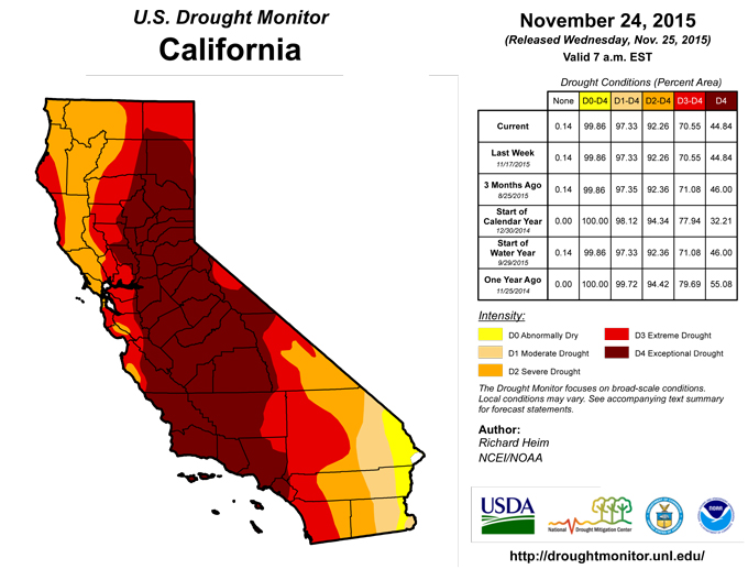
Parts of the northern coast of California received up to 2 inches of precipitation this week, and some northern sections of the Great Basin measured a few tenths of an inch, but most of California and the Great Basin received no precipitation. According to November 22 USDA reports, 85% of the topsoil and 85% of the subsoil in California was rated short or very short of moisture (dry to very dry). In Utah, 48% of the subsoil and 36% of the topsoil was short or very short of moisture. No change was made to the drought depiction in this region.
Southeast
Much of the Southeast received 1 to 3 inches of rain, with several areas of improvement. The D0 in northwest Alabama and south central Tennessee was split and trimmed, and the D0 in southern Alabama and central Georgia was removed. In southwest Georgia and the adjacent Florida panhandle, D1 was deleted and D0 trimmed. But portions of southeast Georgia missed out on the rain this week, with less than half an inch recorded. D0 was added to Wayne, Long, Liberty, and McIntosh Counties to reflect dry conditions over the last 7-14 days and last 2-6 months.Southwest
A good soaking rainfall over portions of the main Hawaiian Islands this week resulted in the removal of D0 from Kauai and Oahu. Half an inch to 3 inches of rain fell in northern and eastern Puerto Rico, with less than half an inch in the southwest parts of the island, but the precipitation was not enough to change the drought depiction. Alaska had a mixed precipitation anomaly pattern and generally below freezing temperatures, which locked the D0 depiction in place.The Northeast
Two or more inches of precipitation fell across parts of coastal New England. The amounts decreased to the west, with less than a tenth of an inch widespread over western New York. It was wet enough to prevent expansion of D0, but the precipitation that fell on the D0-D1 areas in the Northeast was not enough to improve conditions, except in Massachusetts. Cape Cod CoCoRaHS and COOP stations recorded widespread 1-2 inches of rain, with the Nantucket Island COOP station reporting 1.91 inches. This made Cape Cod precipitation anomalies wet out to the 90 day time scale, but they were still drier than normal at 6 to 11 months. But the precipitation was enough to pull back the D0 from Cape Cod and the nearby islands. Even with 0.5-1.5 inches of precipitation this week, northern New Jersey was still below normal for the month and longer time scales, so no change was made to the depiction here. November 22 USDA reports indicated that 51% of the subsoil and 45% of the topsoil in Connecticut was rated short or very short of moisture (dry or very dry). In Vermont, 22% of the subsoil was short or very short of moisture. In New Jersey, 21% of the subsoil and 21% of the topsoil moisture was short or very short. In New Hampshire, 21% of the topsoil moisture was short or very short.Looking Ahead
As the current USDM week came to a close, an upper-level low pressure system was poised to generate rain and snow over a large part of the West. The system will slowly move to the east during the next 5 days (November 25-29), bringing heavy precipitation, once again, to parts of the Plains and Mississippi Valley. Most of the Lower 48 States can expect at least a tenth of an inch of precipitation, with the southern Plains to Ohio Valley receiving one to as much as 8 inches. Parts of the West can expect up to an inch of welcomed and much-needed precipitation. Parts of the Southwest, northern Plains, and Southeast will see the least precipitation. Temperatures are expected to be below normal in the West beneath the upper Low, and above normal east of the Rockies in the southerly flow of warm and humid Gulf of Mexico moisture.For the ensuing 5 days (November 30-December 4), the odds favor below median precipitation from the Southwest, along the Rocky Mountains, and into the northern Plains, as well as western Alaska. Above-median precipitation is expected in southern and eastern Alaska, along the West Coast of the CONUS, in the southern Plains, and from the Mississippi Valley to the East Coast. Temperatures are forecast to be below normal from the Great Basin and central Rockies to the southern Plains, and above normal for Alaska and most of the rest of the CONUS.
Author(s):
Richard Heim, NOAA/NCEI
Dryness Categories
D0 ... Abnormally Dry ... used for areas showing dryness but not yet in drought, or for areas recovering from drought.Drought Intensity Categories
D1 ... Moderate DroughtD2 ... Severe Drought
D3 ... Extreme Drought
D4 ... Exceptional Drought
Drought or Dryness Types
S ... Short-Term, typically <6 months (e.g. agricultural, grasslands)L ... Long-Term, typically >6 months (e.g. hydrology, ecology)
Source: National Drought Mitigation Center
