


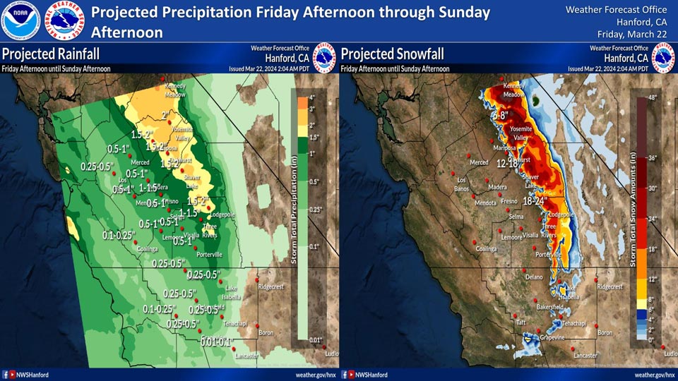
Projected rainfall for Mariposa and Oakhurst: 1.50" to 2.00"
Projected rainfall for Yosemite Valley: 2.00"
March 22, 2024 - National Weather Service Hanford Office officials report light to moderate rain and mountain snow are expected in central California Friday afternoon through Sunday afternoon.
Here are the current projected rainfall and snowfall amounts.
Area Forecast Discussion
National Weather Service Hanford CA
137 AM PDT Fri Mar 22 2024
.KEY MESSAGES...
1.Above normal temperatures will be present once again today,
before a cooling trend moves in for the weekend.
2.A storm system will impact Central California by this weekend,
resulting in periods of rainfall in the San Joaquin Valley and
snowfall in the Sierra Nevada. Gusty winds are in store for the
desert areas of eastern Kern County.
3.A Winter Storm Warning has been issued for the Sierra Nevada
mountains from later today until Sunday. Total snow
accumulations are expected to be 1 to 2 feet from 6,000 feet to
7,000 feet and 2 to 3 feet above 7,000 feet.
4.There is a 10-20 percent chance for thunderstorms in the San
Joaquin Valley on Saturday to the north of Kern County.
5.Another storm system is expected to impact the area by the
middle of next week, beginning on Wednesday.
&&
.DISCUSSION...
One more relatively warm day is on tap for today with highs
around 7 to 10 degrees above seasonal averages. However,
cloud cover increases. The initial band of precipitation arrives
late this afternoon into the evening. A slight chance of
thunderstorms is in the forecast for areas mainly north of
Fresno for late this afternoon into this evening. Rain and
mountain snow will continue to flow into the region as the cold
front progresses southward while winds increase this evening.
Thunderstorm chances spread southward by Saturday, though
mainly for areas north of Kern County. Winds increase in the
desert of eastern Kern County on Saturday morning and continue
at times until late Sunday. The probability of gusts above 45
mph is 50 to 80 percent, sufficient for issuance of a Wind
Advisory. In the meantime, the bulk of the precipitation will
occur from early Saturday morning until the afternoon. The
chances for snow accumulations of at least a foot are at 60 to
90 percent for most locations in the Sierra Nevada above 6,000
feet. As for amounts at or above 18 inches (which would be the
48-hour window ending on Sunday evening), latest guidance shows
probabilities of 20 to 50 percent for mainly elevations above
7,000 feet. Snow levels will lower by late Saturday afternoon in
much of the Sierra Nevada, and reach around 4,500 feet by the
evening hours. Below average temperatures prevail throughout our
forecast area beginning this weekend.
Precipitation chances will continue into Sunday, as well as
gusty winds in eastern Kern County. The presence of cool air
and moisture produces about a 10 to 20 percent chance of a
dusting of snow on the Grapevine in Kern County for Sunday
morning, so we will continue to monitor for this potential,
though confidence is still low at this time. In addition, a
slight chance of thunderstorms also exists in the Central Valley
for Sunday afternoon as the atmosphere remains unstable. The
trough of low pressure associated with this system moves
eastward by Sunday night and is replaced with weak ridging
moving from the E Pacific. This will provide us a break from
unsettled weather until midweek. Latest long-range guidance
continues to show another low pressure system that arrives next
Friday into the following weekend. This corresponds to the above
average precipitation shown in the 6-10 day and 8-14 day
outlooks issued by the Climate Prediction Center which is 50 to
50 percent chance along with a tilt in the odds (mainly around
40 percent chance) that below average temperatures will
continue.
&&
.AVIATION...MVFR in showers in the SJ Valley and adjacent
foothills, with IFR and mountain obscurations due to RA/SN in
Sierra Nevada, after 00Z Saturday. Also, there is a slight
chance of isolated evening thunderstorms after 00Z Sat, mainly
north of KFAT. Otherwise, VFR conditions will prevail across the
central CA interior for the next 24 hours.
&&
.AIR QUALITY ISSUES...
None.
&&
.CERTAINTY...
The level of certainty for days 1 and 2 is high.
The level of certainty for days 3 through 7 is medium.
Certainty levels include low...medium...and high. Please visit
www.weather.gov/hnx/certainty.html for additional information
and/or to provide feedback.
&&
.HNX WATCHES/WARNINGS/ADVISORIES...
Winter Storm Warning from 5 PM this afternoon to 5 PM PDT
Sunday for CAZ323-326>331.
Wind Advisory from 8 AM Saturday to 11 PM PDT Sunday night
for CAZ337>339.
Source: NWS

