


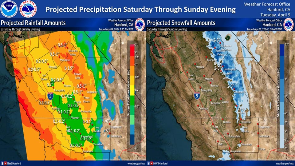
Projected Rainfall for Mariposa: 0.50" to 1.00"
Projected Rainfall for Yosemite Valley: 0.50" to 1.00"
April 9, 2024 - National Weather Service Hanford Office officials report a storm system will impact Central California Saturday through Sunday evening, resulting in periods of precipitation.
The majority of this precipitation will fall Saturday.
The snow level will start at around 6,000 feet Saturday, before dropping to about 5,000 feet Saturday night.
Area Forecast Discussion
National Weather Service Hanford CA
241 AM PDT Tue Apr 9 2024
.KEY MESSAGES...
1. A warming trend will continue through the work week with
temperatures 10 to 20 degrees above normal by Thursday.
2. Another disturbance could move through Central California
late Friday through the weekend, resulting in cooler
temperatures and a chance for precipitation.
&&
.DISCUSSION...
As a low pressure system continues to pull away from the
region, a ridge of high pressure extends inland across
California, bringing dry and mild conditions to our area.
Temperatures have been trending upward for the start of this
week, and highs on Monday afternoon topped out just a few
degrees below normal for this time of year.
As high pressure strengthens along the west coast, our warming
trend will continue for the next few days. Today will see a
significant increase in temperatures, as afternoon highs climb
to around 3 to 6 degrees above normal, then by Thursday we can
expect maximum temperatures to reach around 15 degrees above
climatological averages. Probabilities of reaching at least 86
degrees in the San Joaquin Valley on Thursday are mostly around
50 to 60 percent north of Fresno County and around 80 to 90
percent southward.
The high pressure ridge will give way to an approaching
Northeast Pacific low pressure system by the end of the week.
Model ensemble solutions are reasonably similar in the evolution
of this system, though still show some differences in strength,
timing and trajectory. Blended model guidance generates
precipitation chances near the Yosemite vicinity by Friday
afternoon, spreading southward across our area through Saturday
and lingering into Sunday, with heaviest precipitation
accumulations Saturday and Saturday night, during which time
snow levels are forecast at around 6000 feet.
Total snow amounts in the Sierra Nevada from this system are
forecast to be around 8-12 inches at the higher elevations,
with just a 10 percent probability for getting as much as 12-18
inches. Total QPF is progged to be around 2 to 4 tenths of an
inch in the San Joaquin Valley and as much as three fourths of
an inch to around an inch into the foothills and Sierra below
the snow line. Expect around 1/4 to 3/4 of an inch in the Kern
County Mountains and just a few hundredths in the desert areas.
High-end amounts for the Valley (10 percent probability of
exceedance), are around 1/3 to 3/4 of an inch. High-end QPF in
the surrounding terrain is around one to one and a half inches,
while the Kern County Mountain areas have a 10 percent
probability of seeing 1/3 to 3/4 of an inch. High-end for Kern
County desert areas tops out around one to two tenths of an
inch.
The low pressure system will also bring lower temperatures, with
highs trending a few degrees down on Friday, then near a 15
degree drop for Saturday and lowering further to around 4-8
degrees below normal by Sunday. Probabilities of reaching high
temperatures no higher than 70 degrees on Sunday in the Valley
are around 70 to 80 percent. The low pressure system is progged
to swing southeast away from California early next week,
returning dry and warming conditions to our area.
&&
.AVIATION...
VFR conditions expected across interior Central California
for at least the next 24 hours.
&&
.AIR QUALITY ISSUES...
None.
&&
.CERTAINTY...
The level of certainty for days 1 and 2 is high.
The level of certainty for days 3 through 7 is medium.
Certainty levels include low...medium...and high. Please visit
www.weather.gov/hnx/certainty.html for additional information
and/or to provide feedback.
&&
.HNX WATCHES/WARNINGS/ADVISORIES...
None.
Source: NWS

