


California and National Drought Summary for January 12, 2016
Summary
Much of the Midwest continued to be 6-9 degrees warmer than normal in the past week. New England was warm, too, with Maine and northern New York as much as 9-12 degrees warmer than usual. Areas in northern Washington, Idaho, western Wyoming and much of California were 3-6 degrees warmer than usual, as were the coastal areas of the Mid-Atlantic and much of Florida. For areas west of the Missouri River, temperatures were generally cooler than normal, by as much as 9-12 degrees in parts of Arizona, New Mexico, Montana and South Dakota. On the wet end of the spectrum, much of southern California, southern Nevada, Arizona, southern Utah, southern Colorado, Kansas, northwest Missouri, southeast Nebraska, western Iowa, southern Florida, eastern Pennsylvania, and Maine recorded more than 200 percent of normal precipitation, with multiple storm events in the West. But the Pacific Northwest, northern Great Plains, south Texas, and the Southeast all had below-normal precipitation for the week.Hawaii, Alaska and Puerto Rico
No changes were made to any of these areas this week with the message of status quo received for both Hawaii and Puerto Rico.High Plains and South
Portions of east Texas, east Kansas, southeast Nebraska, and the Texas Panhandle that were in the wettest part of the storm track got more than 200 percent of normal precipitation for the week. Temperatures were generally 3-6 degrees cooler than normal, as a good push of arctic air made it into the region. No changes were made in the High Plains or South on this week’s U.S. Drought Monitor.Midwest
Temperatures remained on the warm side over most of the Midwest, with northern Michigan hitting 8-10 degrees above normal. Much of the Midwest recorded precipitation for the week, with the wettest areas being from southern Illinois into Indiana, Ohio, and Michigan, with total precipitation for the week over 1 inch. This precipitation led to removal of all the abnormally dry conditions from Indiana, Ohio, and much of southern Michigan this week. No other changes were made in the Midwest.Southeast
The Southeast stayed dry this week, with most areas recording below-normal precipitation. The exception to this was in Florida, where areas of the Panhandle and south Florida were on the wet side, with some severe weather impacting western Florida as well. Temperatures were 2-4 degrees cooler than normal for most of the region. Exceptions were coastal North Carolina and much of the Florida Peninsula, where temperatures were 2-4 degrees above normal. There were no changes made to the U.S. Drought Monitor in this region this week.The Northeast/Mid-Atlantic
Much of northern New England recorded temperatures that were 8-10 degrees above normal. Above-normal precipitation from Virginia to Maine allowed for some removal of abnormally dry conditions in Pennsylvania, New Jersey, New York and Vermont. Moderate drought conditions were improved over northern New Jersey and areas of New York. But abnormally dry conditions expanded over portions of West Virginia and southwestern Pennsylvania, which continued to be dry.West
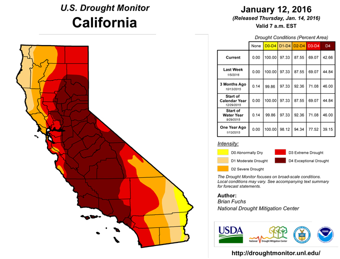
As a series of storms came ashore along the West Coast and dove into the Southwest, many areas of California, Nevada, Arizona, Utah, New Mexico, and Colorado received significant amounts of rain and snow. Along with the cooler-than-normal temperatures, this was ideal for snow to accumulate in the higher elevations and for rain to infiltrate into soils. In Arizona, even though some time-scales are showing dry signals, the consensus was that the recent precipitation was enough to start showing improvements. Severe drought disappeared from Arizona, while much of the moderate drought ebbed in the central and northwest part of the state. Abnormally dry conditions shrank over much of central Arizona as well. In southwest Utah, moderate drought and abnormally dry conditions receded. Eastern Nevada has had good snow over the last several weeks, and snow water equivalent (SWE) is running 150-200 percent of normal for the water year, so moderate drought was removed over much of eastern Nevada. Continued dryness over much of northern Wyoming and southeast Montana led to a slight expansion of moderate drought and abnormally dry conditions this week. Most snow reports have this area at only 20-40 percent of SWE for this time of year.In California, even with the rain and snow received over the last several weeks, many areas are still running below normal for precipitation and snow for the current water year. Wells, reservoirs, ground water, and soil moisture are all recovering slowly, which is to be expected after three-plus years of drought. Precipitation in northern California eased some of the exceptional drought. The consensus from California experts is that recovery will be slow, and many more storm events are needed through the rest of winter to really put a dent in the drought.
Looking Ahead
Over the next 5-7 days, an active pattern will bring precipitation to much of the Pacific Northwest and northern California, which could see as much as 8 inches of precipitation. Much of the area from the Mississippi Valley to the east also looks favorable for precipitation, with the greatest amounts along the Gulf Coast and Eastern Seaboard. Temperatures will be normal to slightly above normal over the West and East, cooler than normal over the High Plains, and above normal over the Southern Plains.The 6-10 day outlooks show that the best chances for above normal temperatures are over the area west of the Rocky Mountains with the greatest chances over the West Coast. The best chances for below normal temperatures is over the Eastern Seaboard. The best opportunity for above normal precipitation is over much of California and into the Great Basin. Increased chances of above normal precipitation can also be anticipated over much of the Plains and into the Southeast. The greatest odds of below normal precipitation is anticipated over south Texas and the Great Lakes region into northern New England.
Author(s):
Brian Fuchs, National Drought Mitigation Center
Dryness Categories
D0 ... Abnormally Dry ... used for areas showing dryness but not yet in drought, or for areas recovering from drought.Drought Intensity Categories
D1 ... Moderate DroughtD2 ... Severe Drought
D3 ... Extreme Drought
D4 ... Exceptional Drought
Drought or Dryness Types
S ... Short-Term, typically <6 months (e.g. agricultural, grasslands)L ... Long-Term, typically >6 months (e.g. hydrology, ecology)
Source: National Drought Mitigation Center

