


California and National Drought Summary for April 12, 2016
Summary
This week was generally uneventful in those parts of the country experiencing abnormal dryness and drought, with only a few patchy areas received 1 to 3 inches of precipitation. As a result, dryness and drought either remained unchanged or deteriorated where it existed.Southeast and Lower Mississippi Valley
Of the areas in and near existing dryness, only part of north-central Georgia recorded as much as 1 to 2 inches of rain last week, with southeastern Georgia, northeastern Florida, and the central Carolinas receiving 0.5 inch or less. Due to impacts from rainfall over the past few weeks, D0 was removed from parts of northeastern Florida, but also expanded southward along the Atlantic Coast slightly. Moisture shortages and low streamflows have been slowly increasing from northern Georgia through the Carolinas. Ninety-day rainfall totals 4 to 7 inches below normal are common, and part of central North Carolina has received only about half of normal precipitation for the year to date. The D0 area expanded slightly, but with relatively few impacts reported, no areas of drought were introduced this week.The Plains
In central and southern parts of the Plains, between 1 and 3 inches of precipitation fell on southern Oklahoma, and in a narrow swath from southwestern Oklahoma northeastward through southeastern Kansas and into central and southwestern Missouri; however, D0 was removed from only a few small spots where the largest amounts fell. A few patches in other parts of southern Kansas and central Texas reported about an inch, but light precipitation at best was observed elsewhere. D2 (severe drought) was introduced in parts of northwestern Oklahoma, and moderate drought expanded to cover west-central Kansas and an area from east-central Kansas into northwestern Missouri. Some locales from central Kansas southwestward across northwestern Oklahoma, the Texas Panhandle, and adjacent New Mexico reported less than 25 percent of normal precipitation for the last 90 days, and amounts totaled 4 to 8 inches below normal in parts of central and eastern Oklahoma, southeastern Kansas, southern and western Missouri, and northwestern Arkansas.Farther north, only a few tenths of an inch of precipitation, if any, fell across the northern Plains, causing expansion of the areas experiencing abnormal dryness and moderate drought. Deterioration to D1 was noted in northeastern South Dakota and adjacent sections of North Dakota and Minnesota, as well as a smaller area in northwestern South Dakota. Farther south, abnormal dryness was introduced throughout the remaining northern tier of South Dakota, and in a band extending through south-central parts of the state. Over the last 30 days, 0.5 to 1.5 inches of precipitation fell on most locations, with little or none observed in western North Dakota, eastern Montana, and the parts of South Dakota and adjacent areas where deterioration occurred on the Drought Monitor.
The Rockies and Intermountain West
The past 7 days brought 0.5 to locally 2.5 inches of precipitation to much of southeastern Nevada, northwestern Arizona, and adjacent areas of Utah and the desert in California. Similar amounts were noted in central New Mexico and a few other scattered small areas, but in general, a few tenths of an inch of precipitation fell on the southern half of the Rockies and Intermountain West, and only scattered areas to the north reported measurable precipitation. Dryness and drought persisted unchanged in most of the region. D0 was extended northward in southwestern parts of the San Juan Range where snowpack peaked at only 80 percent of the typical annual maximum. Farther north, a reassessment of conditions led to the removal of D0 and a slight reduction of the drought area in part of northeastern WyomingThe Far West
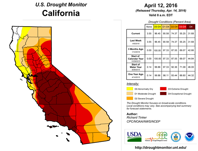
Significant precipitation (1.5 to 3.0 inches) fell on the northern half of the area of exceptional drought in California, including part of the San Joaquin Valley, while lesser measurable totals fell on the rest of California and Nevada. In the context of the protracted drought that has gripped California and adjacent areas for the past few years, the benefit of one week of moderate to heavy precipitation in the most intensely affected areas was minimal, and no changes were introduced in any of the dry areas in California, Nevada, and Oregon.Hawaii, Puerto Rico, and Alaska
Subnormal precipitation and above-normal temperatures for at least the past couple of months brought abnormal dryness into the Alaskan Panhandle; light precipitation was not sufficient to alter the D0 areas farther north and west. Likewise, only isolated moderate precipitation fell on the parts of Hawaii and Puerto Rico experiencing dryness and drought, and the depiction is unchanged from last week.Looking Ahead
Heavy precipitation is expected in some of the driest parts of the Plains during the next 5 days (April 14 – 18, 2016). Generally 3 to locally over 6 inches is forecast from the Texas Panhandle northward through western sections of Oklahoma, Kansas, and Nebraska as well as eastern Colorado. Forecast totals decrease markedly outside of this area, but amounts approaching or exceeding an inch are expected for much of the Plains from southern Texas northward through the central Dakotas. Moderate to locally heavy precipitation is also anticipated for southeastern Georgia and northeastern Florida, but only light precipitation, if any, is anticipated in the remaining areas of dryness and drought across the contiguous 48 states.Over the ensuing 5 days (April 19 – 23, 2016), the odds favor wetter than normal weather from the southern half of the Plains eastward across the Gulf Coast States, and in the northwesternmost part of the Alaskan Panhandle. In contrast, enhanced chances for subnormal precipitation exist for the areas of dryness and drought in the central Appalachians, Northeast, northern Plains, Rockies, Intermountain West, and Far West. In addition, the odds favor below-normal precipitation in part of the east-central Alaskan dry area.
Author(s):
Richard Tinker, NOAA/NWS/NCEP/CPC
Dryness Categories
D0 ... Abnormally Dry ... used for areas showing dryness but not yet in drought, or for areas recovering from drought.Drought Intensity Categories
D1 ... Moderate DroughtD2 ... Severe Drought
D3 ... Extreme Drought
D4 ... Exceptional Drought
Drought or Dryness Types
S ... Short-Term, typically <6 months (e.g. agricultural, grasslands)L ... Long-Term, typically >6 months (e.g. hydrology, ecology)
Source: National Drought Mitigation Center
