Update: 10:30 A.M.
4,933 Acres and 50% Containment
Incident Statics
Acres Burned: 4,933
Structures Threatened: 0
Containment: 50%
Structures Damaged: 0
Fire Start Date: July 19, 2014
Injuries: 0
Fire Discovered: 8/15/14
Total Personnel: 570
Fire Cause: Lightning
Cost to date: $2.58 million
Est. Containment: 9/21/14
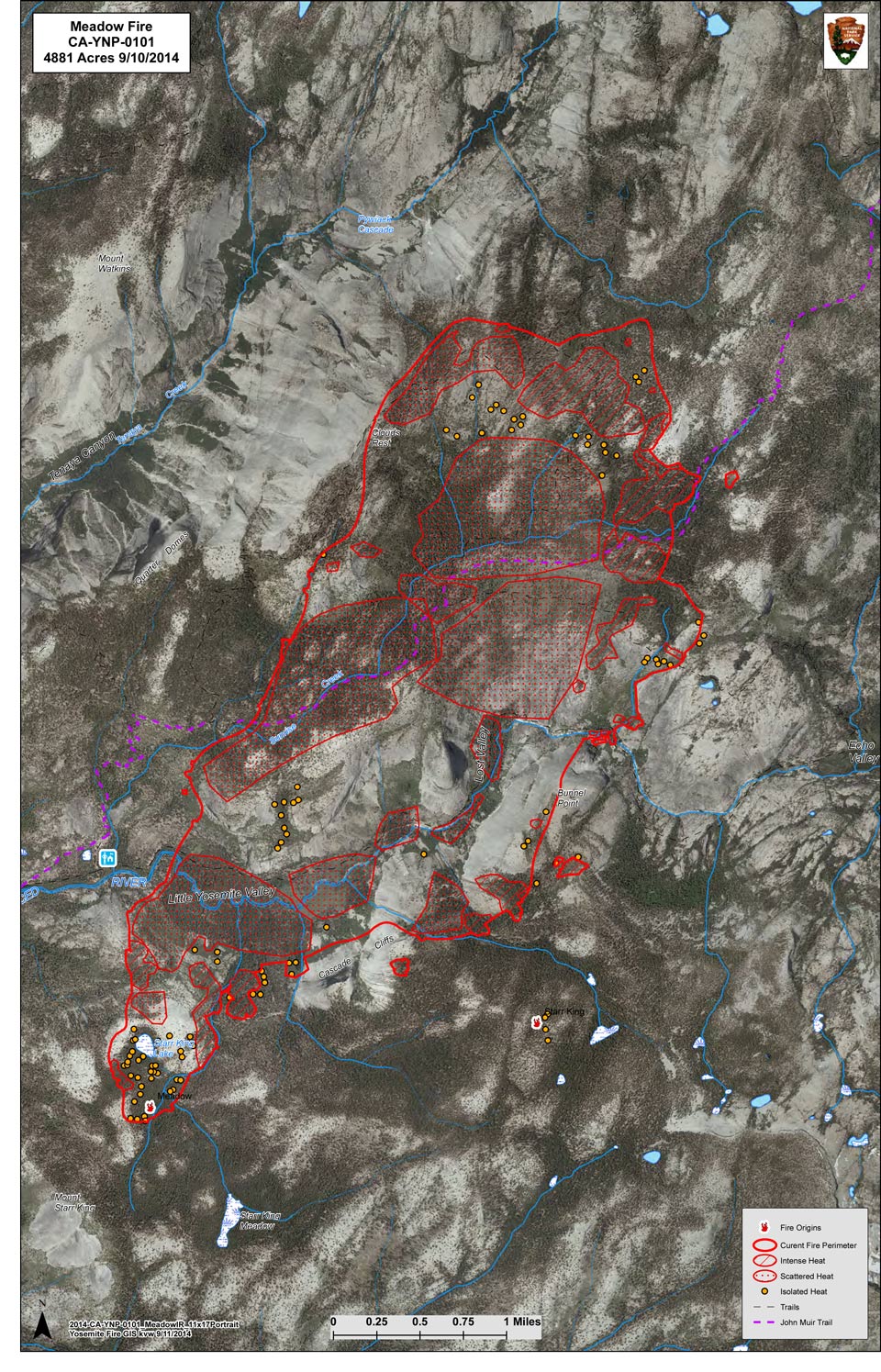
Summary: The Fire is located within the designated wilderness of the Yosemite National Park in Mariposa County and is currently within Little Yosemite Valley between Half Dome and Mount Starr King on both sides of the Merced River.The fire spread significantly due to a wind event which occurred on September 7, 2014.In Yosemite National Park, fire managers operate within the federal guidelines to keep fires burning long enough to determine the threat or benefit the fire may or may not have on the parks ecology. Most fires within the Yosemite National Park naturally burn themselves out. Only a small number of fires show potential for large fire growth and fire suppression action is needed to mitigate the threat to resources. Fire is an important component to the health of the parks sensitive ecology.Recreation and businesses remain open in the Yosemite National Park except trail areas listed below.Fire UpdateFirefighter and public safety remains the highest priority. Fire crews are being sensitive to environmental and cultural resources in and around the fire area. Last night’s infrared flight shows a few acres growth in the fire to the southwest, but otherwise there was minimal perimeter growth. Intense heat still remains along the east flank. There is still isolated heat sources scattered throughout the fire.
Due to the extremely steep, rugged and inaccessible terrain, some fire crews are being flown into the area by helicopter. Air resources, including eight helicopters are being utilized along the fire-line to slow the forward progress of the fire and to cool down hot spots. Due to the potential fire growth and extensive amount of work which remains, a high commitment of resources will be required.Fire crews are using Minimum Impact Suppression Tactics (M.I.S.T). Fire crews are confining and containing the naturally caused fire by utilizing natural barriers such as, rock to rock, rock to domes, decomposed granite (DG) to sparse fuels. Crews are working hard to maintain natural habitat in the wilderness and working diligently to limit the foot print the suppression effort may cause.The fire continues to burn through popular hiking areas in Yosemite National Park and trail closures still remain in effect.
Smoke from the Meadows Fire will continue to impact visitors, campers and employees overnight and in the early morning hours in Yosemite Valley.Fires can produce heavy smoke that blows down into Yosemite Valley. Be prepared for smoke in the unhealthy AQI range normally worse in the mornings with some clearing in the afternoon hours.
Information for schools can be found on this site and links to current air quality updates for this incident will be posted on the California Smoke Information blog.
Trail Closures
By order of the Superintendent of Yosemite National Park and under authority of Title 36, Code of Federal Regulations, Section 1.5(a) and Section (a)(1):Echo Creek Drainage to Little Yosemite ValleySunrise Creek Drainage to Little Yosemite ValleyMerced River Corridor to Merced Lake Ranger StationNevada Falls east through Little Yosemite Valley along the Merced RiverSunrise Trail to Clouds Rest from Tenaya Lake
Cooperating agencies includeU.S. Forest Service, National Weather Service and California Conservation Corp.
For More Information:
Fire information: gary_wuchner@nps.gov
Fire Information call center: (209) 372-0327; 372-0328; and, 372-0329.
For Yosemite air quality data and webcams: www.nps.gov/yose/naturescience/aqmonitoring.htm
For smoke updates: www.californiasmokeinfo.blogspot.com
Yosemite National Park Web page:http://www.nps.gov/yose/parkmgmt/current _fire.htm
Update: 8:30 A.M.
4,933 acres, 50% contained.
Update: 7:13 A.M.
There was a little growth tonight along the eastern edge and to the south west as well as a little on the west.
The spots outside the line along the northeast edge also showed some growth. There were isolated heats at or over the line.
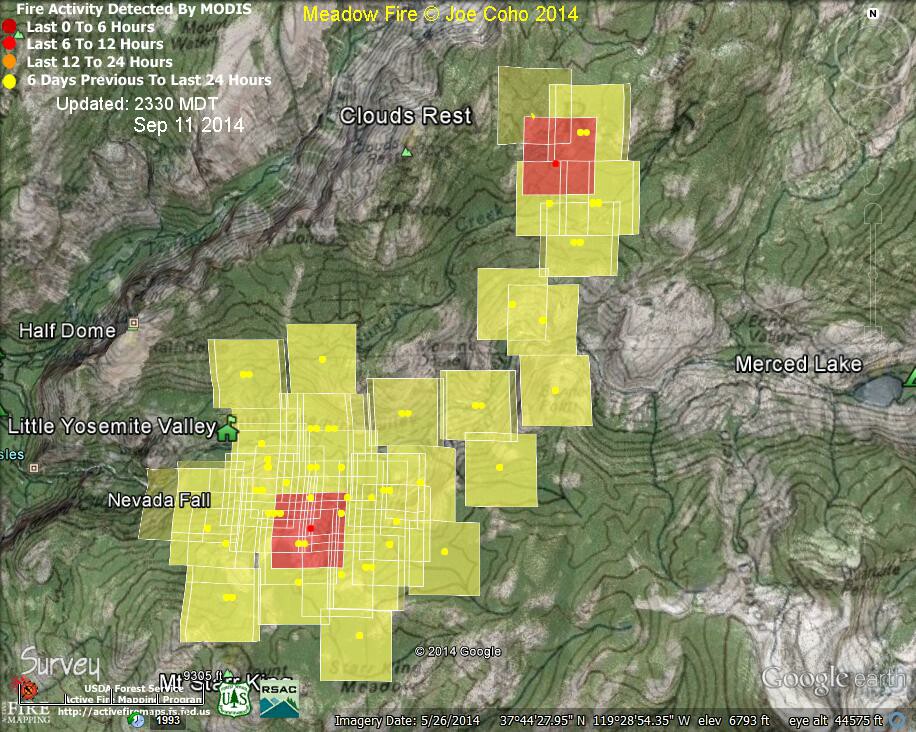
Friday Heat Map
For a Large Map Click Here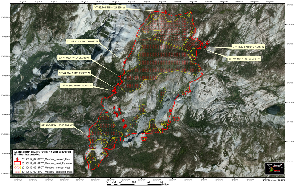
Update: 3:34 A.M.
IAP Fire Perimeter Map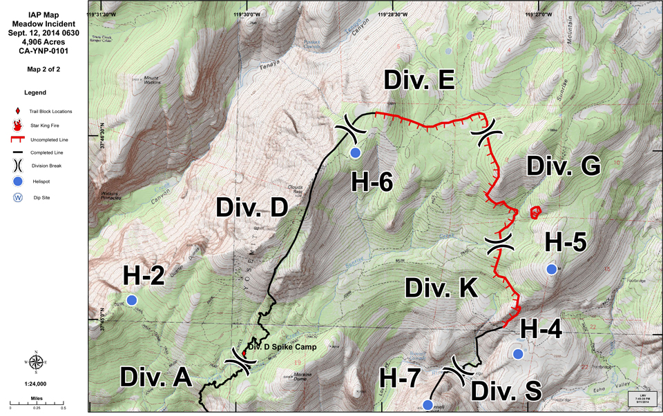

Meadow Fire MODIS Fire Detections 2330 MDT Sep 11 2014
Joe Coho "Meadow Fire MODIS Fire Detections 2330 MDT Thursday Sep 11 2014.
The most recent detections from the Aqua satellite at 1333 PDT Sep 11 2014 are inside the previous boundaries of the fire."
Meadow Fire Perimeter Map
Photo Credit: Courtesy of Yosemite Fire GIS
For a Large Map Click Here