


California and National Drought Summary for June 14, 2016
Summary
June 16, 2016 - Precipitation for the USDM period (June 7-14) was generally below normal for much of the country. Areas that received above normal rainfall were in Florida and along the coast Georgia and the Carolina’s. This was associated with Tropical Storm Colin which exited the coast late in the previous period. Precipitation fell in the Great Basin and central Arizona improving drought conditions in parts of this area. Other areas that received above-normal rainfall were the Northern High Plains and the Southern Plains. Precipitation continued to be minimal in the Northeast, Great Lakes area, Midwest and Northwest, prompting the expansion of DO in the areas that are experiencing low stream flows and parched soils. Temperatures were warmer than normal in much of the western half of the country. The highest anomalies were located in the Northern High Plains where temperatures were at least 10 degrees above what is typically expected during the period. Temperatures were below normal in the Northeast and Great Lakes region.Northeast and Mid-Atlantic
Both above and below normal precipitation fell in the Northeast during the period, with more areas in the below normal side. The wet areas tended to be the areas without drought while the dry areas continued to see less precipitation than normal. Precipitation is approaching 50 percent of normal during last 30 and 60 days. Stream flows at 28 days are less than the 5th percentile and SPI’s indicate abnormally dry conditions throughout the area. These dry conditions warranted the expansion of D0 in northern New York, southwestern Pennsylvania and south central Maine. A new area of D1 was created where the 3-month SPI (March-May) is showing extreme drought in north Jersey and west Long Island. More moderate conditions are seen at timescales further out. In the Mid-Atlantic States of West Virginia, Virginia, and Maryland, the rate of growth has slowed as the soils have dried out and temperatures build. DCA and BWI airports have received less than 30 percent of normal precipitation for the month-to-date period. The situation in these areas is carefully being monitored for future introduction of D0.South and Southeast
Drought conditions persisted across much of the Southeast during the period. Scattered showers occurred in places but precipitation amounts were well below normal and not enough to contract any of the existing drought areas. The heaviest rains fell in the coastal sections of the Carolinas and Georgia and in much of Florida. Precipitation measurements since the beginning of June are running 25 percent of normal in places across the Southeast. Warm temperatures and the lack of precipitation continue to dry out the top soils thus stressing vegetation. Stream flows in the driest 10th percentile are being reported across the Southern Appalachians where all drought categories were expanded slightly. The SPI’s at 60 and 90 days continue to show severe to extreme drought in portions of northern Georgia and Mississippi. Moderate drought was expanded well into central Mississippi to reflect the poor conditions. Severe drought was expanded across south central Tennessee and into northern Alabama. Further west into Louisiana, drought conditions improved due to recent rains. D0 was eradicated in northeast Louisiana based on neutral to wet 60- and 90-day SPI’s. In Texas, the small area in the Panhandle of D0 was removed.Midwest
Conditions continue to worsen across the Midwest during the period. Concerns for a flash drought are high as the lack of precipitation and high temperatures continue to desiccate the soils and stunt the growth of crops. Some of the area did see beneficial rains during the period but not enough to ward off the expansion of drought. The driest areas stretch from central Kansas and Nebraska, eastward into the tri-state area of Iowa, Missouri and Illinois. Precipitation is measuring 10 percent of normal or less in that area during the past 14 days. Meanwhile temperatures are exceeding 5 degrees F above normal, exacerbating the dryness. In Iowa, it is reported that lawns are drying out and soils are cracking. In Missouri, farmers have noticed moisture stress in the corn leaves, the growth of forages have slowed significantly and creeks and streams are beginning to run low. Based on these abnormally dry conditions, DO was introduced to much of Missouri, Illinois and Indiana.High Plains
Precipitation was a mixture of above and below normal for much of the High Plains during the period. A broad area of above normal precipitation fell in eastern Montana, stretching eastward across northern North Dakota. In general, this area received about one inch greater than normal precipitation during the period. Further eastward into Minnesota, recent precipitation was enough to slightly contract the existing D0 in the south central part of the state and create a small doughnut hole in the northeastern part of the state. Pockets of below normal precipitation dotted the landscape, but the driest area was centered around the tri-state area of North and South Dakota and Minnesota. Again, generally speaking, this area recorded precipitation totals that were about one inch less than normal. Short and long term SPI values continue to deteriorate in the tri-state area. Stream flows are less than 10 percent and winter wheat and alfalfa are beginning to show signs of stress due to the recent dryness. Based on these conditions DO was expanded from southwestern North Dakota northward. In South Dakota, D1 and D0 were expanded from west to east based on the lack of rangeland productivity. Further South, D0 was extended south slightly to reflect the extreme 30 day SPI value in northwest Nebraska. This area is reporting 75-90 percent of normal precipitation in the 60 day time frame and less than 50 percent of normal in the 30 day time frame. In Montana, the winter snow melted about 2-4 weeks early. Additionally, short term precipitation deficits and low stream flows have compounded the situation. The abnormal dryness was reflected by expanding D0 in western Montana. D0 was also slightly expanded in the northwest corner of Wyoming to reflect the recent lack of precipitation and warm temperatures.Northwest
Precipitation for the period was above normal for the Washington coast but generally below normal elsewhere. Much of Oregon and Idaho saw half inch departures below normal for the period. The precipitation departures in the Climate Divisions of the North Central Prairies and the Central Mountains of Idaho were 1 to 1.5 inches below normal. Temperature anomalies for the period varied. Much of Washington and Oregon were 3 degrees F below normal while Idaho was 3-6 degrees F above normal. Based on long term precipitation deficits, low stream flows and negative SPI’s, D0 was expanded across Oregon and slightly into Idaho. It was noted that the winter snows in Oregon have already melted away. In Washington, low stream flows, poor soil moisture and lack of water storage resulted in a slight expansion of D0.West
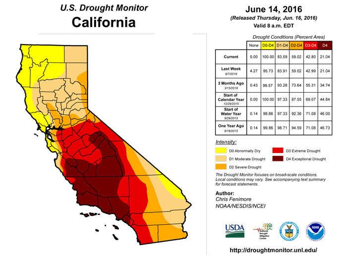
Above normal precipitation fell in central and southern Nevada and into north and south central Arizona during the period. These areas received up to 1 inch of precipitation more than what is typically seen during the period. Elsewhere precipitation deficits approached one-half inch or less than 5 percent of normal. Temperatures in the region were generally 3-6 degree F above normal except for a few small areas along the California Coast that were around 3 degrees F below normal. In northern California the canals are full, and water is in good supply at the moment. However, with the rapid snow melt this year, water supply may be a concern later this summer. The lack of precipitation during May is also a concern. For the first 11 days of June, precipitation values across northwest California are 5 – 20 percent of average. D0 was expanded to cover all of northwest California to reflect these conditions. Further south in San Diego and Sacramento, officials are expecting an above average fire season. All CalFire stations are at full staffing for the summer, about a month earlier than normal. No changes were made in Central or southern California. In the Reno area, impressive rainfall totals from the previous weekend allowed for further contraction of D3 along the crest of the White Mountains.Hawaii
In Kauai vegetation has improved over the past several weeks resulting in a small reduction in the east side of the D1 and D0 area. On Oahu Island, there was a small reduction in the northeastern side of the D1 area. Above average rainfall in May has improved conditions considerably on the Big Island. The rainfall arrived along the Kona slopes in time to save the coffee crop for the year. Ranchers have reported improved forage and stock water supplies, especially in the Kohala area and the northwestern slopes of Mauna Kea. The upper slopes of the Kau District have also improved. However, not everywhere on the Big Island has shown improvement. Ag extension service staff indicated that conditions were dry above the lower elevations (2000 ft) on the Hamakua slopes. Based on these impacts there was a large reduction in the D2 area covering the southwest half of the island, but an increase in the D0 area on the east side.Alaska and Puerto Rico
No changes were made this week in Alaska and Puerto Rico.Looking Ahead
In the short term (through June 21), temperatures as much as 6 degrees F cooler than normal are forecasted to occupy much of the Northwest, while much of the interior of the country will continue to bake in 5-10 degree F above normal heat. Precipitation totals for the 5-day period ending on June 20 are forecasted to exceed 2 inches in southern Alabama and northern Florida as well as parts of the Mid-Atlantic. Based on the Climate Prediction Center’s 6-10 day outlooks (June 20-24), the greatest probability of warmer than normal temperatures will occur in the Desert Southwest and extending into the Great Basin and Southern Rockies. Odds are in favor of near normal temperatures for the Southeast Coast and Northern High Plains and Great Lakes area. Below normal precipitation is most probable for much of the Northwest and a narrow swath of area stretching from the Southern Plains into the Tennessee Valley. Odds are in favor for above normal precipitation to occur in the coastal areas of the Gulf Coast states and Florida as well as in the Great Lakes area and parts of the Northeast. For Alaska, there is an increased probability of above normal temperatures for much of southern Alaska. Chances of above normal precipitation exist for much of Alaska, especially for northwestern Alaska.Author(s):
Chris Fenimore, NOAA/NESDIS/NCEI
Dryness Categories
D0 ... Abnormally Dry ... used for areas showing dryness but not yet in drought, or for areas recovering from drought.Drought Intensity Categories
D1 ... Moderate DroughtD2 ... Severe Drought
D3 ... Extreme Drought
D4 ... Exceptional Drought
Drought or Dryness Types
S ... Short-Term, typically <6 months (e.g. agricultural, grasslands)L ... Long-Term, typically >6 months (e.g. hydrology, ecology)
Source: National Drought Mitigation Center
