


Highlights
Slightly below normal “monsoon” thunderstorm activity.
Fewer number of thunderstorms this summer, but a greater chance of dry lightning compared to last year.
Near normal to slightly above normal temperatures.
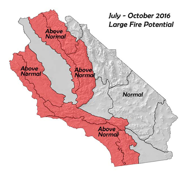
Above normal large fire potential over a large area suggesting a very busy season lies ahead.
July 1, 2016 - Climate Predictive Services - Valid from July through October, 2016
Weather Discussion
Record-setting temperatures developed over the district during the last two weeks of the past month. The relatively pleasant temperatures of May and early June were replaced by well above normal temperatures as one of the strongest ridges in the past few years built across the Southwest. Temperatures during the 19th-20th reached over 110 in many valley and lower foothill locations while the low desert saw readings over 120. The heat was accompanied by single digit RH and strong sunshine.
While the heatwave did not last long, it was intense enough to cause rapid curing of all fuel types across the entire region. Several large fires quickly developed during the peak of the heatwave as fuel temperatures were extremely high each afternoon. The two large fires in the Angeles National Forest exhibited rapid rates of spread, even during the absence of wind. Once windier weather arrived a few days later, the Erskine Fire exploded to over 40,000. Sadly, this fire caused two fatalities as well as destroying hundreds of structures. The winds did decrease a few days later, but hot weather during the last week of the month continued to challenge firefighting efforts.
Figures 2, 3: SST’s June 2015 (Left upper) and June 2016 (Left lower)
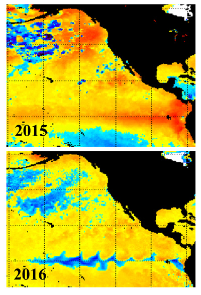
This year, SST’s are much lower…in fact, much of the Pacific now has below normal SST’s (Figure 3 above). This temperature profile will be much less conducive for thunderstorm activity. The past 3 summers have seen an above, to much above number of thunderstorm days. This year, thunderstorm activity will likely be closer to normal.
Figure 4: Possible Synoptic Pattern this Summer
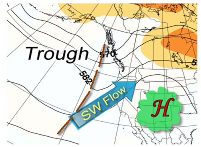
Long range models indicate a strong ridge may be centered over the Southwest and southern plains through much of the summer. A weak trough may linger over the Pacific Northwest. This arrangement of the troughs and ridges would support more of a southwesterly flow aloft which is a dry pattern, hostile to the formation of thunderstorms (Figure 4, above).
While there will likely be fewer thunderstorm days this year, there may be a higher risk of dry thunderstorms. Last year, nearly every storm that formed was wet as a saturated airmass allowed heavy rain to fall from most of the storms. Therefore, despite the high amount of lightning, the number of new starts from thunderstorms was low. This year, a much higher proportion of the storms may be dry compared to the past few years. Forecasting these storms will be the primary challenge of the season. Given the extremely dry fuel status across the entire area, it would only take one sizeable outbreak of dry lightning to generate a heavy amount of initial attack. Due to the possibility of dry lightning and the dry fuels, most of the area outside the desert will have a higher than normal threat of large fires through the summer and early fall. At this time, offshore wind frequency looks to be near normal.
Fuels and Drought Outlook:
The rapid uptick in fire activity seen last month is a good indication of the grim state of the fuels over most of the area. June is usually a relatively quiet month with grass fires contributing the most to wildfire acreage. This year, fires that started in the grass and other fine fuels quickly transitioned into heavier vegetation. The Coleman fire in Monterey County grew quickly during rather benign weather conditions. Additionally, this fire occurred before the heatwaves later in the month and fuel conditions are even drier than during the initial phase of the fire. The Sherpa Fire in Santa Barbara County also grew rapidly during a wind event, but the surface conditions were cool and humid – underscoring the extremely dry vegetative state.
Figure 5: Tree Mortality Progression 2014-current
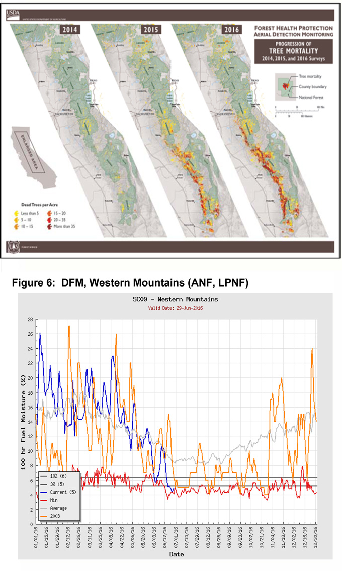
A recent survey of the Sierras conducted by the USFS, paints a disturbing picture of the fuel conditions across Central California (figure 5, Above). Continuous drought the past 5 years has weakened trees, allowing them to be susceptible to the bark beetle. A heavy concentration of heavy, dead and highly combustible fire material now exists in the Sierras, especially in the Sierra and Sequoia National Forests. Tree mortality is nearly uniform in these areas with broad expanses of dead trees as opposed to the patchwork of dead trees from a year or two ago. Any lightning outbreak in this area will likely demonstrate a high level of ignition efficiency. Fire behavior may also be extreme in this area with long range spotting and crown runs during hot or windy periods.
Most long-term ENSO model data points toward the possibility of a La Niña developing by the fall. However, models seem to be trending away from the strongly negative ENSO levels seen in previous runs. SST along the equator may end up being slightly below normal or perhaps at a neutral condition by the winter if the model trends continue. Either way, no relief from the exceptional drought which grips over 20% of the state (and roughly 50% of South Op’s area of responsibility) is expected anytime soon.
Large fires will continue to be highly resistant to control efforts during hot and windy periods. Offshore wind events this fall may only serve to exacerbate this situation. Large fire potential may not fall to near normal levels before November or December – at the soonest. The combination of extremely dry and desiccated fuels along with the potential for dry lightning this summer may result in the busiest and most dangerous fire season in years.
Source: NIFC

