


California and National Drought Summary for August 30, 2016
Summary
September 1, 2016 - This U.S. Drought Monitor week saw a swath of above normal precipitation stretching from western Texas northeastward through parts of western Oklahoma, much of Kansas, northwest Missouri and into northern Illinois. A combination of moisture flowing in from the Southwest and Southeast along with a stalled frontal boundary brought abundant precipitation to areas of Texas and New Mexico. The heaviest rains during the period fell in western Texas and southeast New Mexico where at least 5 inches were measured. Approximately 5 inches of rain also fell in northwest Missouri and northeast Iowa. Elsewhere high pressure remained in control along the east and southeast coast line limiting precipitation to nothing more than typical summer time convection, resulting in drier than normal conditions all along the Eastern seaboard. Louisiana continued to experience wetter than normal conditions, further pushing their statewide precipitation total to a possible record amount for August. Virtually no precipitation was observed west of the Rockies. Temperatures for the period ranged from 6-8 degrees below average in the Four Corners region to 6-8 degrees above average in eastern Ohio. Generally speaking, above average temperatures were observed in the eastern half of the Country along with the Northwest, while below average temperatures occurred in the Northern Plains and south into the Southwest and Texas.Plains and South
Areas in eastern Kansas saw at least 1 inch more precipitation than what is typically expected. Some areas measured as much as 6 inches more than normal. D0 was removed in the east part of the state. Widespread rains contributed to the removal of some D0 in western Kansas. Precipitation during the USDM period in Oklahoma was generally above normal, especially in the west part of the state. Anomalies were 4-5 inches above normal in some locations. In central Oklahoma 7-day percent of normal precipitation was less than 5 percent in an area stretching from Norman to south of Tulsa. Deficits at 30-days resulted in expansion of D0. It was reported that as a result of the longer term deficits, fire danger in Oklahoma has increased. A mixed bag of precipitation amounts fell in Iowa during the 7-day period. Areas in the northeast and southwest had amounts greater than 500 percent of normal. On the flip side, the west central part of the state only recorded 25 percent of normal or less. Based on this, 1-category improvements were made in the south central and southeast. D0 was expanded in northwest Iowa, bleeding into southwest Minnesota. A crop report from Wayne County, Iowa indicated that there is sufficient top soil moisture with the recent rains. However, sub soil moisture is still short to very short. Drought conditions in Nebraska were reduced along the south central, northeast and northern panhandle. Meanwhile, abnormally dry conditions were expanded in southwest Nebraska. Precipitation in Texas was much above normal in the western portion of the state for the 7-day period, with totals approaching 500 percent of normal. A small area along the coast and the Louisiana border also received above normal rains during the period. The last 30-days, a much wider swath of precipitation fell along the east. These conditions led to D0 improvements in central, western and southeastern Texas.Northeast
Overall the Northeast was drier than normal for the USDM period. The rain event that occurred during the first part of the USDM week dropped 1.5 inches at the Buffalo airport and over an inch at several nearby co-op stations. Although the long-term factors (such as groundwater) are low but stable, near term factors such as creek flows have recovered considerably and it was reported that lawns and foliage have greened up in the Buffalo metro area. This resulted in D3 being trimmed back in the area. Aside from east central Pennsylvania where D1 was slightly contracted due to above normal precipitation, drought conditions worsened in Massachusetts and surrounding areas. Due to the recent and longer term lack of precipitation across this area, there were many more degradations and expansions. Below normal precipitation fell in much of the region at the 7-, 14-, and 30-day periods. The hardest hit areas were along the coast. As of August 31, preliminary data suggest that New Jersey may have its fifth driest August on record. The dryness has been exasperated by extreme warmth throughout much of the region. Preliminary data also suggest that many of the Northeast states may be record warm for the month. These dire conditions warranted expansion of severe drought in Cape Cod. Streamflows in the area were reading less than 2 percent of normal at the 28-day time period resulting in then expansion of extreme drought in New Hampshire and southeastern Massachusetts.Southeast
The southeast continued to see hit and miss summer time convection across the area this past week. Abnormally dry conditions were introduced in much of central North and South Carolina as the 30-day precipitation amounts are well below normal. D0 was also expanded in southeast Georgia where 28-day streamflows are running 5-10 percent of normal. SPI’s at 30 days indicated that D1 needed expansion along the Georgia coastline and eastern Alabama. D2 was slightly contracted in northern Mississippi. Based on preliminary data, average temperatures for the month of August could approach record warm values for several states across the region.West, Northwest and Southwest
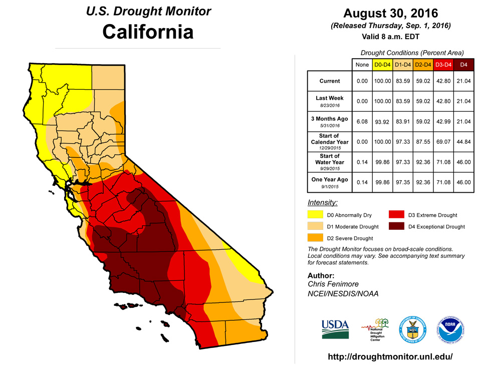
Light precipitation fell in parts of Wyoming, southern Utah, much of Arizona, New Mexico and Colorado. Average temperatures were generally 2-6 degrees F below normal in those areas. Some readings were as much as 8-10 degrees F below normal. Based on 30 and 60 day departures, D0 was expanded in the south and an expansion of D1 was made in western Montana and eastern Idaho. In Colorado, a 1-cat improvement was made in the southwest based on 30- and 60-day percent of normal precipitation. The Southwest monsoon produced another round of precipitation for eastern New Mexico during the period. But it was not enough to affect drought conditions there. It is the dry season, so little to no precipitation is not surprising in California. Drought conditions there will remain status quo for the time being.Hawaii, Alaska and Puerto Rico
Above average rainfall through August over the leeward areas of Oahu alleviated all drought. In Maui, conditions are improving over the slopes of the Upcountry region. However, lower elevations remain dry. Rainfall continues to improve conditions on the Big Island, warranting a 1-cat improvement. No changes were made in Alaska and Puerto Rico this period.Looking Ahead
According to the Climate Prediction Center (CPC), the heaviest precipitation will fall along the coast of Florida and the Carolinas over the course of the next 24-48 hours. This is associated with Tropical Storm Hermine. As the Tropical Storm moves along the eastern seaboard, it is forecasted to leave several inches of rain in its wake. During the next 5 days, precipitation is expected to be in the 1-2 inch category across the New Mexico and Texas border region stretching north and eastward into Oklahoma and into the Dakotas. Maximum temperatures during the next 3-5 days will be in the 90’s across much of the southern plains and Tennessee valley, while mid-60’s will be seen in the High Plains. According to the CPC, chances are greater than normal to have above average temperatures in the eastern half of the country while the High Plains may experience below average temperatures. During the same period odds are in favor for above average precipitation to fall in the Great Lakes region. Below average precipitation is expected in the Southwest and much of the East Coast. Looking further out at 8-14 days, odds are favorable that above average temperatures will occur in Northeast while the High Plains continues to be below normal. Precipitation during the period is likely to be below normal in portions of the Southeast, but above normal for the Midwest.Author(s):
Chris Fenimore, NOAA/NESDIS/NCEI
Dryness Categories
D0 ... Abnormally Dry ... used for areas showing dryness but not yet in drought, or for areas recovering from drought.Drought Intensity Categories
D1 ... Moderate DroughtD2 ... Severe Drought
D3 ... Extreme Drought
D4 ... Exceptional Drought
Drought or Dryness Types
S ... Short-Term, typically <6 months (e.g. agricultural, grasslands)L ... Long-Term, typically >6 months (e.g. hydrology, ecology)
Source: National Drought Mitigation Center
