


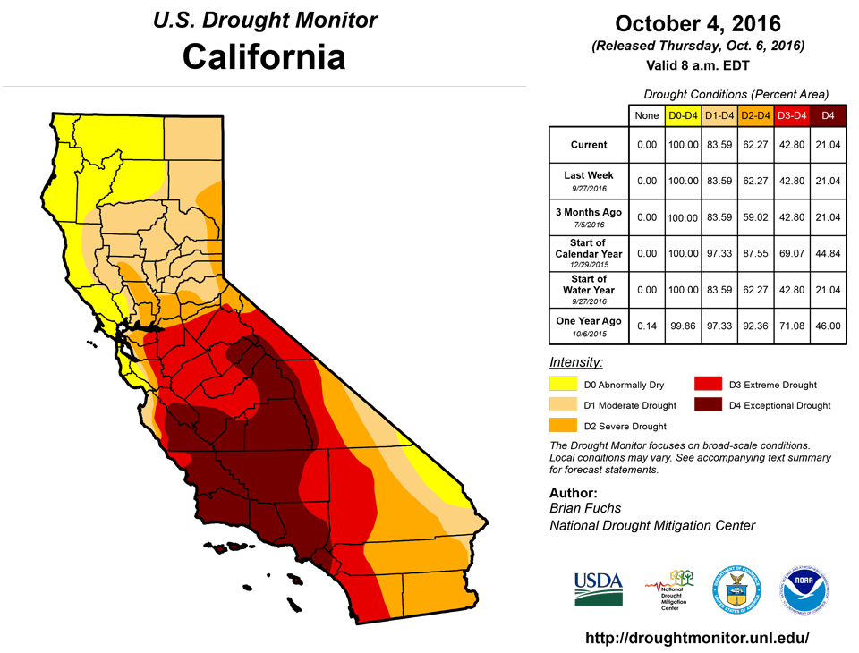
California and National Drought Summary for October 4, 2016
Summary
October 6, 2016 - The current U.S. Drought Monitor period was dry through much of the Midwest and Plains states. Dryness also dominated much of Idaho, the interior regions of Washington and Oregon, much of California and Nevada, and the Southeast. A slow-moving system brought with it soaking rains from eastern Illinois into the Mid-Atlantic. Some areas of the Mid-Atlantic into Virginia and North Carolina recorded over 5 inches of rain with this event. The soils were primed to soak in the moisture and little runoff was observed, as short-term dryness had dominated this area. Eastern Idaho, northwest Wyoming and central Montana all had good rains this week as well as some of central and eastern Arizona, into western New Mexico. Temperatures were cooler than normal over the coastal regions of the Pacific Northwest and into northern California as well as Arizona where the wet conditions were observed. Much of Texas and Louisiana were cooler than normal; below-normal temperatures also extended up the Mississippi River Valley into portions of Kentucky and Tennessee. Warmer than normal temperatures dominated much of the Rocky Mountains, Central and Northern Plains, Upper Midwest, and East Coast. Some departures in eastern Montana were 6-8 degrees above normal.The Northeast
The Northeast was warmer than normal for the week, with areas of western and northern New York recording temperatures 2-4 degrees above normal. Wet conditions dominated much of Pennsylvania and southern New York, but most of the region remained dry with very little rain recorded in New England. Drought improved over southern New Jersey and into southern Pennsylvania where both moderate drought and abnormally dry conditions were eliminated. In New York, the western edge of the extreme drought was reduced as an assessment of the current indicators showed little support remaining for D3. Drought conditions intensified in Connecticut and portions of southeast New York into Long Island, and a new area of D2 was introduced into northern New York, into Vermont.Mid-Atlantic
A slow-moving rain event impacted much of the region after dryness had been established in the area. Temperatures were warmer than normal with departures of 6-8 degrees above normal in southern Virginia and northern North Carolina. Most of the region was well above normal for precipitation this week; some areas of southeast North Carolina, eastern Maryland and Delaware, and northern and eastern Virginia all recorded over 5 inches above normal rainfall for the week. Abnormally dry conditions were improved through much of the region in response to the rain event and its impact on the indicators.Southeast
Temperatures were mixed in the region, with the eastern portions 4-6 degrees above normal while the east was 2-4 degrees below normal. Outside of the Florida peninsula and eastern North Carolina, dryness dominated the region. The drought impacting the region worsened as the combination of the dryness and above-normal temperatures allowed for degradation this week in Georgia, Tennessee, Alabama, western South Carolina, western North Carolina and Mississippi. Generally speaking most of these areas had a full category degradation where the data supported it. Exceptional drought was expanded into more of northwest Georgia and into far northeastern Alabama. Moderate drought expanded over much of central Mississippi while pockets of severe drought were expanded over Alabama and Georgia and into Tennessee.Midwest
Dry and warm conditions dominated the Midwest this week, which is not much of a complaint for agricultural producers who are in harvest mode. Some areas from eastern Illinois into Michigan, Indiana, and Ohio did record up to 2 inches of rain, but most of the rest of the region was dry. Temperatures were generally normal in the southern portions of the Midwest to 6-8 degrees above normal in the north. The recent rains did allow for improvements to materialize this week, with a full category improvement for most of Michigan and Ohio, eliminating the moderate drought and leaving behind some lingering D0. Abnormally dry conditions were also improved over southern Indiana and northern Kentucky. As we go into the fall harvest and recharge period, most areas of the Midwest do not have any drought concerns.High Plains and South
Temperatures were warmer than normal over the northern and central Plains while they were cooler than normal over most of Texas, Louisiana and southern portions of Arkansas and Oklahoma. Portions of Nebraska, South Dakota, and North Dakota did pick up some precipitation this week, but the region was generally dry, again helping with fall agricultural activities and crop maturity. Due to the recent patterns, the moderate drought was eliminated from North Dakota, with only a few pockets of lingering D0 remaining. The recent pattern allowed for an assessment of conditions in western South Dakota, where extreme drought was reclassified as severe drought and the extent of severe drought and moderate drought was also reduced. In southwest South Dakota, the recent dryness in the area did allow for the slight expansion of moderate drought and abnormally dry conditions. In Nebraska, the abnormally dry conditions were improved in the western and central portions of the state. Dryness over the last 30-60 days has allowed for abnormally dry conditions to be introduced into southwest Kansas and the Oklahoma and Texas panhandles. In south Texas, moderate drought and D0 were also expanded slightly, and a new pocket of D0 was added along the Gulf Coast. Northeast Texas had more expansion of both moderate drought and D0 conditions this week as a short-term dry pattern continues. Oklahoma had some expansion of severe and moderate drought in the eastern portions of the state, but this may be short-lived as decent rains fell over the expanded area after the data cutoff for the week. Abnormally dry conditions were expanded in eastern Oklahoma, western Arkansas and central Louisiana as well this week.West
The new water year started over the West with some rain along the coastal regions of northern California, Oregon, and Washington as well as much of central and eastern Arizona. Areas in eastern Idaho, southwest Montana, and northwest Wyoming also recorded widespread precipitation this week. Temperatures were warmer than normal from the Great Basin into the Rocky Mountains, with departures of 6-8 degrees above normal. Most other areas were normal to cooler than normal along the west coast, with departures there of 2-4 degrees below normal. Improvements were made this week to the moderate drought in southwest Washington and extreme northwest Oregon. Accordingly, some improvements were also made to the abnormally dry conditions in this area. Abnormally dry conditions also improved in central Colorado, southwest Wyoming and north central Wyoming in response to the most recent wet pattern. An assessment of conditions in northeast Wyoming led to a reduction in severe drought, similar to what was done in the Black Hills of South Dakota. Arizona saw D0 conditions improve in the southeast and northwest portions of the state where the greatest rains fell.Hawaii, Alaska and Puerto Rico
No changes were made this week for Alaska or Puerto Rico. In Hawaii, abnormally dry conditions were reintroduced on Kauai as well as on leeward Oahu and portions of the Big Island. On Maui, severe flash flooding near Wailuku was localized, and it was confirmed by FSA that the severe drought still existed over Kihei and Wailea. The D0 near Lahaina and Kapalua did improve and was removed this week.Looking Ahead
Over the next 5-7 days, many across the Southeast and along the eastern seaboard will be watching to see what Hurricane Matthew does. There is a potential for significant rains over drought areas, so it will be watched closely. Precipitation is anticipated over much of the central United States from New Mexico northeastward into the Great Lakes, with some areas projected to receive 2-3 inches of rain. Another storm system will impact the Pacific Northwest, bringing with it heavy rains along the coastal regions of Washington and Oregon. Temperatures during this time remain above normal, with only those areas along the coastal region, where rain is expected, projected to record temperatures near normal or slightly below.The 6-10 day outlooks show all of the United States and Alaska having above-normal chances of recording temperatures that are above normal; the greatest chances are in the Plains. Precipitation during this time is anticipated to be greatest over the Pacific Northwest. There are higher chances of below-normal precipitation along the East Coast and in the Plains.
Author(s):
Brian Fuchs, National Drought Mitigation Center
Dryness Categories
D0 ... Abnormally Dry ... used for areas showing dryness but not yet in drought, or for areas recovering from drought.Drought Intensity Categories
D1 ... Moderate DroughtD2 ... Severe Drought
D3 ... Extreme Drought
D4 ... Exceptional Drought
Drought or Dryness Types
S ... Short-Term, typically <6 months (e.g. agricultural, grasslands)L ... Long-Term, typically >6 months (e.g. hydrology, ecology)
Source: National Drought Mitigation Center
