Click here for Caldor Fire Friday Updates
California Caldor Fire Friday, September 3, 2021 Updates
Evacuation Orders Downgraded - Effective Immediately
El Dorado County Evacuation Order Update:
The following Evacuation Orders have been downgraded to Evacuation Warnings in El Dorado County:
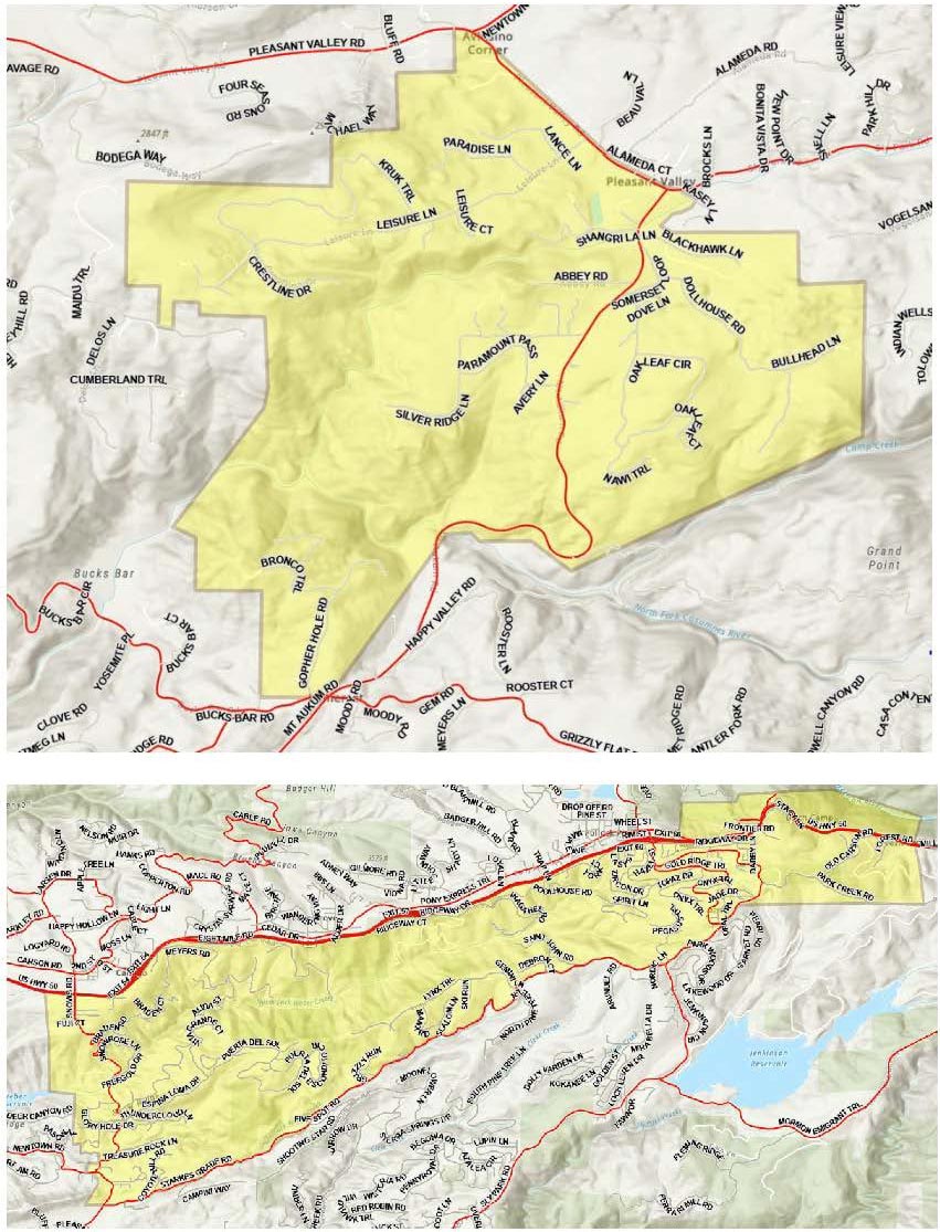
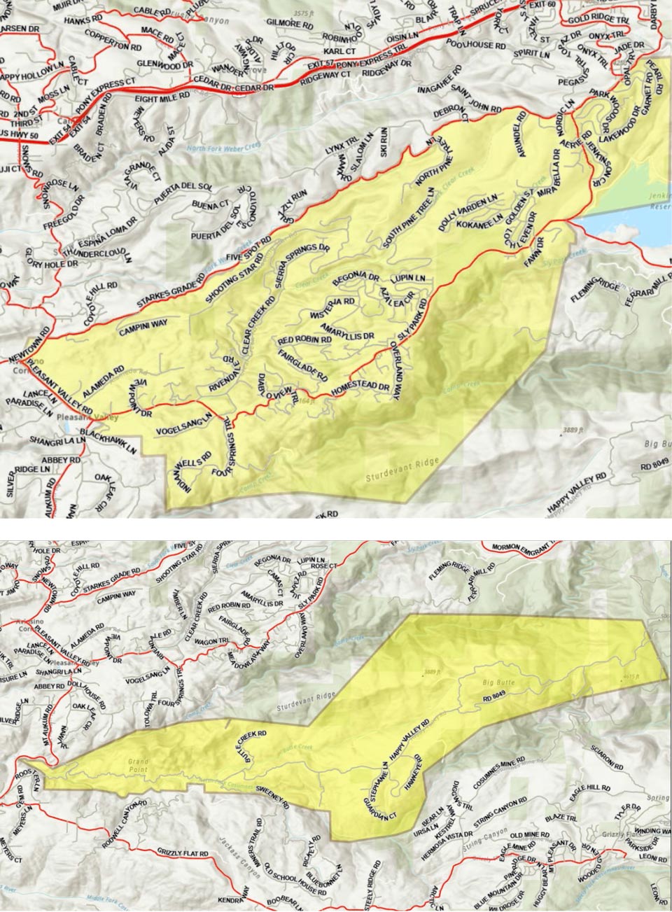
- South Sly Park - South of Starkes Grade Road, north of Sly Park Creek, east of Pleasant Valley Road up to and including the Diamond Garnet subdivision.
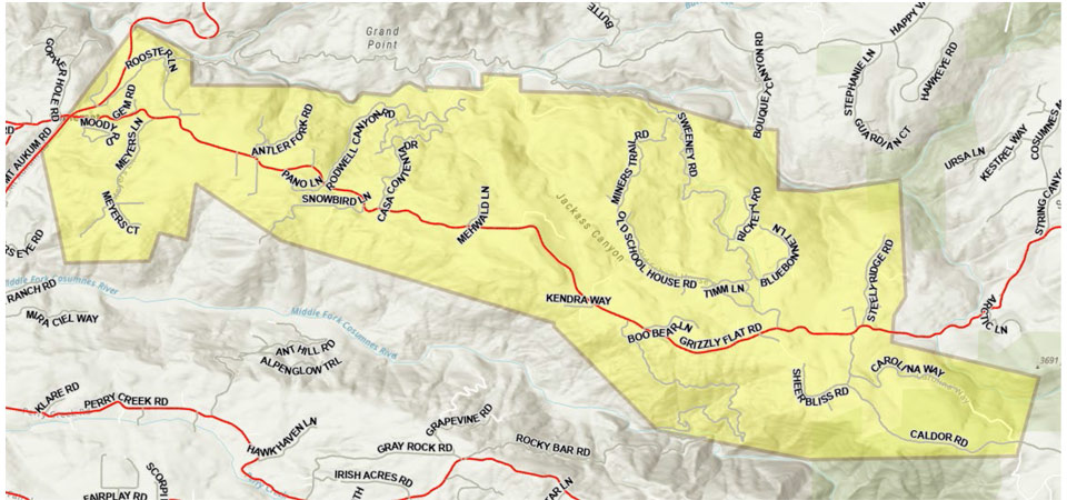
- Grizzly Flats West – East of Highway E16, west of Steely Ridge Road, South of the North Fork of the Cosumnes River and North of the Middle Fork of the Cosumnes River.
- Happy Valley - All properties accessed from Happy Valley Road.
NOTES: The public is reminded to stay vigilant on current fire conditions. Please continue to adhere to road closures and any evacuation orders and warnings. A reminder to drive slowly and yield to emergency personnel in the area. There will be smoke in the respective areas as firefighters continue firefighting operations. If at any time you feel unsafe, please call 911. For tips on returning home after wildfire visit: Returning Home Checklist - Ready for Wildfire
El Dorado Irrigation District (EID) officials request that evacuated residents with water service provided by EID consider running internal taps for a couple minutes upon returning to ensure fresh water in their homes. Water that has remained in service lines during evacuation periods can result in customers detecting taste and odor issues that may be easily addressed by flushing the taps. EID’s water is safe to drink. The main distribution system piping was not affected by fire and the integrity of the overall system has not been affected, as confirmed by its ongoing and rigorous water quality testing program. As CAL FIRE officials allow more EID customers to return home, the District requests that customers refrain from using any non-essential water use during the first 24 hours of returning to their homes. This conservation is requested to allow EID staff to adjust to meeting normal customer demands after supporting key firefighting efforts over the past two weeks.
REMINDER: There is still a temporary Emergency Closure in effect for the Eldorado National Forest through the end of September. This closure includes all National Forest Service lands, roads and trails within the El Dorado National Forest. See Forest Order 03-21-14 for more information. The Lake Tahoe Basin Management Unit is closed under the Regional Emergency Closure of all National Forests in California. See the Regional Order for more information. Recreation residence and other permittees should contact their permit administrator for questions regarding access when their area becomes open for repopulation.
Please go to: www.tinyurl.com/EDSOEVAC for an online evacuation map.
All previous evacuation orders and warnings remain in effect.
A mandatory evacuation order is defined as an immediate threat to life. This is a lawful order to leave now. The area is lawfully closed to public access. An evacuation warning is defined as a potential threat to life and/or property. Those who require additional time to evacuate and those with pets and livestock should leave now.
For additional information regarding the Caldor Fire, scan the QR code above or visit https://linktr.ee/imt6
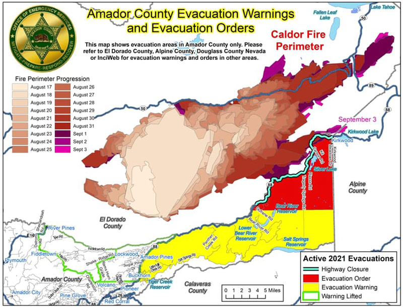
Update: Here is the most up to date map of the Amador County evacuation warning/order zones, as well as the Hwy 88 road closure at Peddler Hill. Attached is also the link to our interactive map.
https://amador.maps.arcgis.com/apps/webappviewer...
September 3, 2021 - Caldor Fire Updates to Evacuation Orders, Warnings, and Road Information for Friday, September 3, 2021.
Evacuation Orders Downgraded - Effective Immediately for El Dorado County
Evacuation Order Update: The following Evacuation Orders have been downgraded to Evacuation Warnings in El Dorado County:
- The area described as South of Pleasant Valley between Bucks Bar Road and Newtown Road, East of Bucks Bar Road to Mt. Aukum Road. This includes the area of Gopher Hole Road and Moonshadow.
- The area described as South of US Highway 50, North of Starkes Grade Road, East of Snows Road and West of Fresh Pond.
NOTES: The public is reminded to stay vigilant on current fire conditions. Please continue to adhere to road closures and any evacuation orders and warnings. A reminder to drive slowly and yield to emergency personnel in the area. There will be smoke in the respective areas as firefighters continue firefighting operations. If at any time you feel unsafe, please call 911. For tips on
returning home after wildfire visit: Returning Home Checklist - Ready for Wildfire
El Dorado Irrigation District (EID) officials request that evacuated residents with water service provided by EID consider running internal taps for a couple minutes upon returning to ensure fresh water in their homes. Water that has remained in service lines during evacuation periods can result in customers detecting taste and odor issues that may be easily addressed by flushing the taps. EID’s water is safe to drink. The main distribution system piping was not affected by fire and the integrity of the overall system has not been affected, as confirmed by its ongoing and rigorous water quality testing program. As CAL FIRE officials allow more EID customers to return home, the District requests that customers refrain from using any non-essential water use during the first 24 hours of returning to their homes. This conservation is requested to allow EID staff to adjust to meeting normal customer demands after supporting key firefighting efforts over the past two weeks.
Please go to: www.tinyurl.com/EDSOEVAC for an online evacuation map. All previous evacuation orders and warnings remain in effect.
A mandatory evacuation order is defined as an immediate threat to life. This is a lawful order to leave now. The area is lawfully closed to public access.
An evacuation warning is defined as a potential threat to life and/or property. Those who require additional time to evacuate and those with pets and livestock should leave now.
Source: CAL FIRE Amador-El Dorado Unit