


Note: Click Here for Saturday's Caldor Fire Updates
Update: Caldor Fire Virtual Briefing & Community Meeting Evening Update Video for Friday, September 3, 2021
Evening Update Per CAL FIRE: California Caldor Fire is at 213,270 Acres, with 32% Containment, and 4,662 personnel assigned for Friday evening.
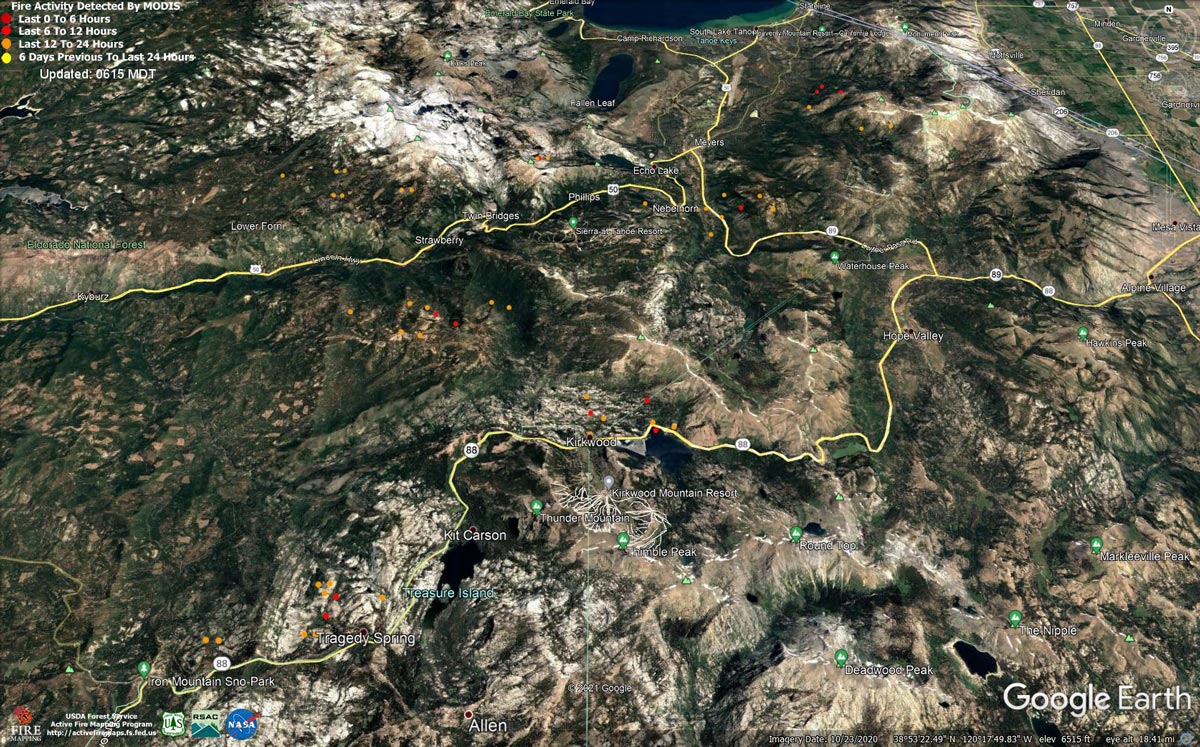
MODIS map of the Caldor Fire on Friday at 5:15 A.M PST
Note: 1,200 Pixels Wide - Note: Older Yellow not shown
MODIS Active Fire Mapping Program Frequently Asked Questions
News: Disaster Unemployment Assistance Has Been Approved for Those Impacted by Widespread California Fires
Update: Caldor Fire Virtual Community Meeting Set for 5:00 P.M. Tonight, September 3, 2021
Update: Caldor Fire Operations Briefing Video for Friday Morning, September 3, 2021
Update: Smoke/Air Quality Outlook for the California Caldor Fire for Friday, September 3, 2021
Update: California Caldor Fire Infrared Map for Friday, September 3, 2021
Update: California Caldor Fire Briefing Map and Public Information Map for Friday, September 3, 2021 - Briefing Map Shows Divisions, Uncontrolled Fire Edge, Completed Dozer Lines
September 3, 2021 - Caldor Fire Update for Friday Morning, 212,907 Acres with 29% Containment.
Update CAL FIRE

Basic Information
| Current as of | 9/3/2021, 7:04:55 AM |
| Incident Type | Wildfire |
| Cause | Under Investigation |
| Date of Origin | Saturday August 14th, 2021 approx. 07:00 PM |
| Location | 4 miles South of Grizzly Flats, 2 miles East of Omo Ranch |
| Incident Commander | Jeff Veik, CAL FIRE IMT6; Joe Reinarz, USFS NIMO 2; Rocky Oplinger, ICT1, USFS CIIMT4 |
| Incident Description | Wildfire |
| Coordinates | 38.584 latitude, -120.534 longitude |
Current Situation
| Total Personnel | 4,415 |
| Size | 212,987 Acres |
| Percent of Perimeter Contained | 29% |
| Estimated Containment Date | Monday September 13th, 2021 approx. 06:00 PM |
| Fuels Involved |
Heavy timber. Steep terrain. |
| Significant Events |
*Evacuation areas are listed according to zones established by the respective county and law enforcement agencies. Full descriptions are available on county websites. DOUGLAS COUNTY, NV EVACUATIONS ORDERS:Upper Kingsbury, Lower Kingsbury • Upper Kingsbury (South), Upper Kingsbury (North), Central Kingsbury, Lower Kingsbury, Lower Olivers, Kahle Drive region, and roads, Lake Village, areas south of Elks Point road. DOUGLAS COUNTY, NV EVACUATIONS WARNINGS: Douglas Zone 2 • Zone 2: Any homes or property located on Foothill Road from Centerville Lane north to Muller. Included in this zone is the valley side of Kingsbury Grade and any homes that are accessed by Foothill Road between Centerville Lane and Muller Lane. ALPINE COUNTY EVACUATION ORDERS: • Zones 19, 20, 21, and 22 ALPINE COUNTY WARNINGS: • Zones 23, 24, and 22A EL DORADO COUNTY ORDERS: North Camino to Ice House, North US 50 East of Forebay to Ice House, South Pollock & Camino Zone, East Sly Park to Ice House Rd, South Sly Park, Leisure, West Happy Valley, Happy Valley, Grizzly Flat West, Cole Station, Omo South, Omo East, Henry's Diggings, Leoni Meadows, Dogtown Creek, Big Mountain, Caldor, Greater Grizzly, Crystal Basin, US 50 South to Kyburz, Caples Creek, Mormon Emigrant Trail to HWY 88, Zone 4a, Zone 5a, Hell Hole, Echo North, Echo South, Christmas Valley, Washoe Meadows, Meyers, Tahoe Island, Tahoe Keys, Sierra Tract, Al Tahoe, Bijou, Heavenly, Stateline, Tahoma, Fallen Leaf, Trimmer, Pioneer, Gardner Mountain EL DORADO COUNTY WARNINGS: Dry Lakes, South of Wentworth Springs, Hwy 50 South/Newton, Springer, Ant Hill, Mt. Aukum, Coyoteville, Pi Pi, North Camino AMADOR COUNTY ORDERS: Zone 4a and 5a AMADOR COUNTY WARNINGS: Zones 1, 2, 3, 4b, 5b |
Outlook
| Planned Actions |
WEST ZONE: Provide for the life safety of citizens and emergency responders. Implement structure and critical infrastructure defense. Construct control lines and take advantage of targets of opportunity as allowed by fire behavior and resource limitations. Improve and hold established control lines. Prepare for firing operations and implement burn plans. Identify and establish contingency lines. Tactical patrol of perimeter contained. EAST ZONE: In the Christmas Valley area crews are continuing to construct direct containment lines from Highway 89 west to Scout Peak to reduce the threat to structures. In the Pioneer Trail area, resources will continue with structure defense tactics, patrolling, prepping structures and utilize direct fire suppression tactics where safe to do so. On the northeastern side of the fire in the Cold Creek Drainage area, resources are working with local utility companies to open road systems to connect to dozer line to stem continued fire spread to the northeast. On the north end of the fire, crews will continue to construct direct fireline from Highway 50 to Echo Lake. In the Echo Lake area, structure defense operations will continue. A contingency group is locating and building contingency lines in the event of fire crossing primary containment lines. Planning is occurring to mitigate potential threat to communities in the Foothill Road area. |
| Projected Incident Activity |
Current Weather
| Weather Concerns |
WEST ZONE: Observed: Downslope and down canyon winds developed at around 2100 and prevailed through the night. Lows ranged from 45-55 over the higher elevations to 55-62 in lower drainages. Relative humidity recovery was modest, reaching the 25-30 percent range. Forecast for Friday: Sunny with patchy smoke. Highs 73-83 upper elevations and 83-92 lower drainages. Winds downslope down canyon through mid morning then becoming upslope and up canyon 5 10 mph with gusts to 15 mph in the afternoon. Gusts to 25 mph possible along the Highway 50 corridor. Relative humidity minimums 11-16 percent. EAST ZONE: Observations: Breezy southwest ridge winds lightened and turned out of the south overnight, eventually turning to the east by early morning with wind speeds around 10 mph. In the lower elevations, winds became downslope 3 to 6 mph with good recoveries in the valleys. Strong inversions formed overnight with very poor humidity recoveries only reaching 20 to 35% along the mid-slopes and ridgelines. Friday Forecast: Extremely dry air will remain over the fire area on Friday with a warming trend through the weekend as high pressure builds over the west. Humidities will drop into the low to mid-teens at all elevations during the day with good recoveries in the valleys and very poor recoveries mid-slope and on ridges. Winds will be generally terrain driven with upslope winds 4 to 8 mph during the afternoon and gusts up to 15 mph in canyons. Ridge winds will be out of the east 10 to 15 mph with poor smoke dispersion. |
Click here for: California Caldor Fire Thursday, September 2, 2021 Updates
