


Note: Click Here for Friday's Caldor Fire Updates
California Caldor Fire Friday, September 3, 2021 Updates
Update: Informational Message from the Amador County Sheriff Concerning the Caldor Fire (with Video)
Evening Update Per CAL FIRE: California Caldor Fire is at 210,893 Acres, with 27% Containment, and 4,415 personnel assigned for Thursday evening.
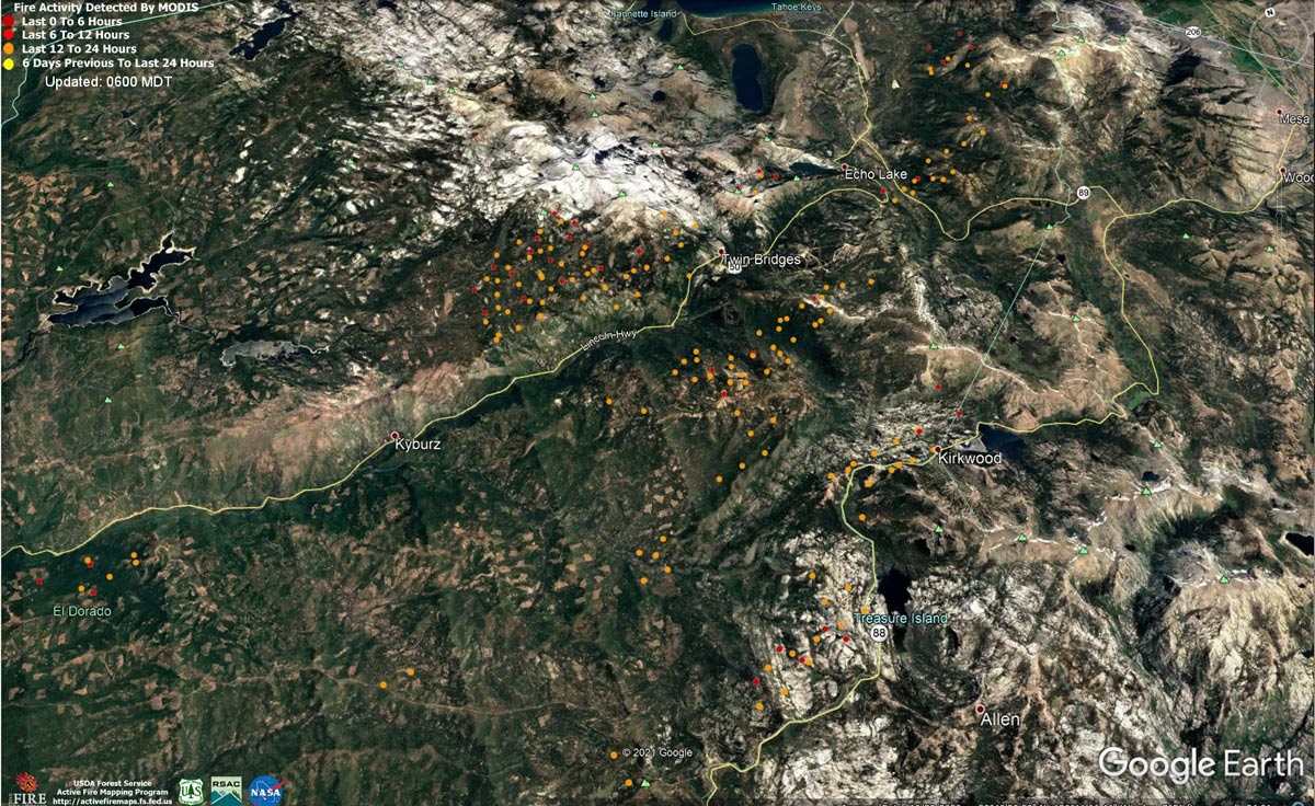
MODIS map of the Caldor Fire on Thursday at 5:00 A.M PST
Note: 1,200 Pixels Wide - Note: Older Yellow not shown
MODIS Active Fire Mapping Program Frequently Asked Questions
Update: Caldor Fire Updates to Evacuation Orders, Warnings, and Road Information for Thursday, September 2, 2021
Update: Smoke/Air Quality Outlook for the California Caldor Fire for Thursday, September 2, 2021
Update: California Caldor Fire Infrared Map for Thursday, September 2, 2021
September 2, 2021 - Caldor Fire Update for Thursday Morning, 210,259 Acres with 25% Containment.
Update: East Zone Caldor Fire
At 1900 yesterday evening, California Interagency Incident Management Team 4, Incident Commander Rocky Opliger, assumed command of the East Zone of the Caldor Fire. The East Zone extends from the community of Strawberry along U.S. Highway 50, north to Pyramid Peak and south to Caples Lake, and then all areas to the east of these landmarks including the communities of Christmas Valley, Meyers, South Lake Tahoe, and Kingsbury.
Weather conditions moderated yesterday with wind speeds not reaching predicted levels and an inversion and heavy smoke remaining over the fire later into the day. Fire growth occurred primarily along the edges near the head of the fire as it made some progression toward the Cold Creek drainage.
Yesterday hand crews assessed opportunities to build direct line along the fire perimeter from California State Route 89 west toward Scout Peak to reduce threats to structures in Christmas Valley. At Echo Lake firefighters were shuttled across by boat to work on structure preparations and hand crews assessed opportunities to build direct line along the fire perimeter from U.S. Highway 50 west toward Echo Lake. Near Pioneer Trail in South Lake Tahoe, dozers continued to build mechanical line along the bottom edge of the slope to keep the fire south of these communities. Engines patrolled and prepared structures that remained threatened. During night operations, specialized night flying helicopters were used to drop retardant from a mobile retardant plant to slow fire progression near Christmas Valley and hot shot crews built direct line along the fire perimeter on the northeast edge of the fire from Trout Creek toward Trimmer Peak.
Today hand crews will build direct line along the fires edge from Christmas Valley west toward Nebelhorn and from U.S. Highway 50 west toward Echo Lake and hot shot crews will continue hand line construction near Trimmer Peak at the northeastern most edge of the fire. In the community of South Lake Tahoe, dozers and hand crews will continue mechanical line preparations near Pioneer Trail and begin improving old road systems in the Cold Creek drainage. Air resources will assist firefighters on the ground with retardant and water drops to slow fire movement and cool hot spots along the fire perimeter as conditions allow. A contingency group will continue structure assessments along Nevada SR207 (Kingsbury) and SR206 (Foothill Road) and in the communities of Fredericksburg, Paynesville, and Woodfords along California SR88.
Update CAL FIRE
Basic Information
| Current as of | 9/2/2021, 7:07:33 AM |
| Incident Type | Wildfire |
| Cause | Under Investigation |
| Date of Origin | Saturday August 14th, 2021 approx. 07:00 PM |
| Location | 4 miles South of Grizzly Flats, 2 miles East of Omo Ranch |
| Incident Commander | Jeff Veik, CAL FIRE IMT6 Joe Reinarz, USFS NIMO 2 |
| Coordinates | 38.584 latitude, -120.534 longitude |
Current Situation
| Total Personnel | 4,451 |
| Size | 210,259 Acres |
| Percent of Perimeter Contained | 25% |
| Estimated Containment Date | Monday September 13th, 2021 approx. 06:00 PM |
| Fuels Involved |
Heavy timber. Steep terrain. |
| Significant Events |
*Evacuation areas are listed according to zones established by the respective county and law enforcement agencies. Full descriptions are available on county websites. DOUGLAS COUNTY, NV EVACUATIONS ORDERS: • Upper Kingsbury (South), Upper Kingsbury (North), Central Kingsbury, Lower Kingsbury, Round Hill region and roads including Lower Elks Point, Lake Village, Lower Olivers, Kahle Drive region, and roads DOUGLAS COUNTY, NV EVACUATIONS WARNINGS: • Zone 2: Any homes or property located on Foothill Road from Centerville Lane north to Muller. Included in this zone is the valley side of Kingsbury Grade and any homes that are accessed by Foothill Road between Centerville Lane and Muller Lane. ALPINE COUNTY EVACUATION ORDERS: • Zones 19, 20, 21A, and 22A ALPINE COUNTY WARNINGS: • Zones 21B, 22B and 23 EL DORADO COUNTY ORDERS: North US 50 East of Forebay to Ice House, South Pollock & Camino Zone, East Sly Park to Ice House Rd, South Sly Park, Leisure, West Happy Valley, Happy Valley, Grizzly Flat West, Cole Station, West Omo, Omo South, Omo East, Omo Ranch Fill, Henry's Diggings, Leoni Meadows, Dogtown Creek, Big Mountain, Barney Ridge, Caldor, Greater Grizzly, Crystal Basin, US 50 South to Kyburz, Caples Creek, Mormon Emigrant Trail to HWY 88, Zone 4a, Zone 5a, Hell Hole, Echo North, Echo South, Christmas Valley, Washoe Meadows, Meyers, Tahoe Island, Tahoe Keys, Sierra Tract, Al Tahoe, Bijou, Heavenly, Stateline, Tahoma, Fallen Leaf, Trimmer, Pioneer, Gardner Mountain EL DORADO COUNTY WARNINGS: North Camino/Pollock, Dry Lakes, South of Wentworth Springs, Mosquito, Carson White Oak, Highway 50 South /Newton, Springer, Ant Hill, Mt. Aukum, Coyoteville, PiPi, Consumes, Cement Hill, Farnham Ridge AMADOR COUNTY ORDERS: Zone 4a and 5a AMADOR COUNTY WARNINGS: Zone 3, 4b, 5b |
Outlook
| Projected Incident Activity |
Current Weather
| Weather Concerns |
WEST ZONE: Observed: The last of the stronger southwest winds aloft abated overnight the fire area and terrain driven downslope and downcanyon winds prevailed. Lows ranged from 48-58 over the higher elevations to 58-65 in lower drainages. Relative humidity recovery was modest, reaching the 30-35 percent range. Forecast for Thursday: Sunny with patchy smoke. Highs 73-83 upper elevations and 83-92 lower drainages. Winds downslope down canyon through mid morning then becoming upslope and up-canyon 5-10 mph with gusts to 15 mph in the afternoon. Gusts to 25 mph are possible along the Highway 50 corridor. Relative humidity minimums 10-15 percent. EAST ZONE: Overnight observations: Breezy ridge winds gusting up to 25 mph lasted through late evening lightening up overnight with gusts to around 15 mph by early morning. Very poor recoveries occurred overnight with humidities only 20 to 35% above 6800¿. In the lower elevations, winds became downslope 3 to 6 mph with good recoveries in the valleys. Thursday Forecast: Ridge level winds will remain slightly elevated out of the southwest during the early afternoon, becoming southeast with lighter speeds overnight. A very dry air mass remains over the region. Humidities will be in the low teens during the day with very poor overnight recoveries in the thermal belts and along the ridges. Valley temperatures will drop into the 30s overnight with good overnight recoveries below about 6800ft. |
Click here for: California Caldor Fire Wednesday, September 1, 2021 Updates
