


Note: Click here for Thursday's Updates:
California Caldor Fire Thursday, September 2, 2021 Updates
News: CAL FIRE Video Shows How Specialized Damage Inspectors Assess Homes After California Wildfires
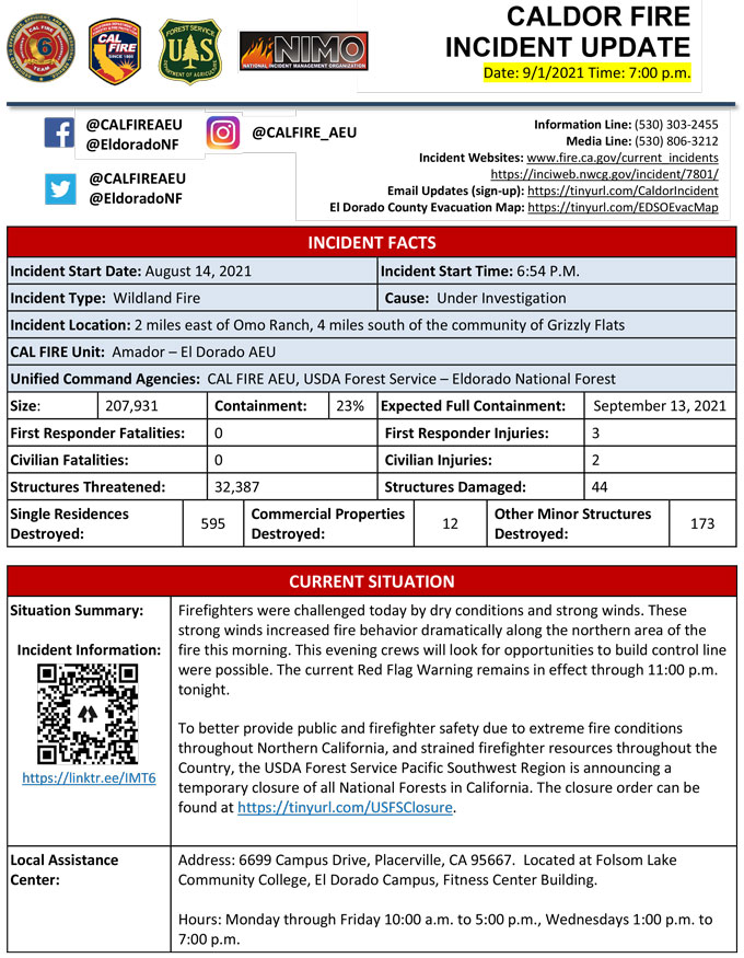
Evening Update Per CAL FIRE: California Caldor Fire is at 207,931 Acres, with 23% Containment, and 4,224 personnel assigned for Wednesday evening.
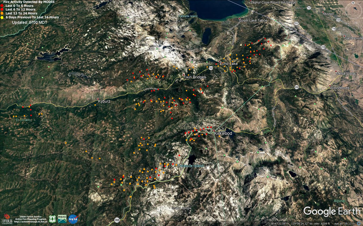
MODIS map of the Caldor Fire on Wednesday at 6:00 A.M PST
Note: 1,200 Pixels Wide - Note: Older Yellow not shown
MODIS Active Fire Mapping Program Frequently Asked Questions
Update: Caldor Fire Virtual Community Meeting Set for 5:00 P.M. Tonight, September 1, 2021
Update: Caldor Fire Operations Briefing Video for Wednesday Morning, September 1, 2021
Update: CAL FIRE Reminds the Media of California Law After Issues Arise at the Caldor Fire
Update: Smoke/Air Quality Outlook for the California Caldor Fire for Wednesday, September 1, 2021
Update: California Caldor Fire Infrared Map for Wednesday, September 1, 2021
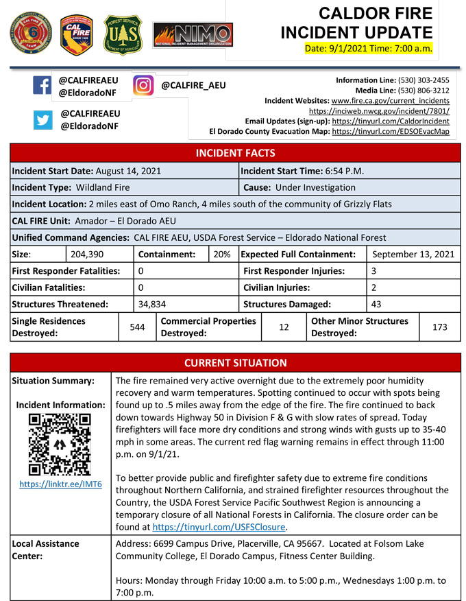
September 1, 2021 - Caldor Fire Update for Wednesday Morning, 204,390 Acres with 20% Containment.
Update CAL FIRE
Basic Information
| Current as of | 9/1/2021, 7:18:13 AM |
| Incident Type | Wildfire |
| Cause | Under Investigation |
| Date of Origin | Saturday August 14th, 2021 approx. 07:00 PM |
| Location | 4 miles South of Grizzly Flats, 2 miles East of Omo Ranch |
| Incident Commander | Jeff Veik, CAL FIRE IMT6 Joe Reinarz, USFS NIMO 2 |
| Coordinates | 38.584 latitude, -120.534 longitude |
Current Situation
| Total Personnel | 4,224 |
| Size | 204,390 Acres |
| Percent of Perimeter Contained | 20% |
| Estimated Containment Date | |
| Fuels Involved |
Heavy timber. Steep terrain. |
| Significant Events |
*Evacuation areas are listed according to zones established by the respective county and law enforcement agencies. Full descriptions are available on county websites. NEW DOUGLAS COUNTY, NV EVACUATIONS 08/31/21 1600HRS: - Upper Kingsbury (South) - Upper Kingsbury (North) - Central Kingsbury - Lower Kingsbury - Round Hill region and roads including Lower Elks Point - Lake Village - Lower Olivers, Kahle Drive region, and roads NEW ALPINE COUNTY EVACUATIONS 08/31/21 1645 HRS: Zones 19, 21, and 22: Highway 88 at Forestdale Road. West of Forestdale Road and south to the Pacific Crest Trail Crossing. West of the Pacific Crest Trail to the Summit City Canyon Trail. West of Summit City Canyon Trail and south to the El Dorado / Stanislaus National Forest Line. El Dorado / Stanislaus National Forest Line west to the Alpine and Amador County line. North of Highway 88, along the Alpine/El Dorado County line and Armstrong Summit to the Nevada state line. West of the Nevada state south to Luther Creek. Northwest of Luther Creek to Woodfords. North of Highway 88 and Highway 89 to the Alpine/El Dorado County line. NEW ALPINE COUNTY WARNINGS 08/31/21 1645HRS: Zones 23, 24, 22A: North of Highway 89 from Woodfords due north to Luther Creek at the Nevada State line. East of Forestdale Road and south to the Pacific Crest Trail Crossing. East of the Pacific Crest Trail to the Summit City Canyon Trail. East of Summit City Canyon Trail and south to the El Dorado / Stanislaus National Forest Line. El Dorado / Stanislaus National Forest Line east to the northern lake edge of Upper Blue Lakes. North of the North-west Lake edge of Upper Blue Lake to the southern aspect of Hawkins Peak and to Woodfords junction. South of Highway 88 at Woodfords Junction to Forestdale Road. EXISTING EVACUATIONS El Dorado County Orders: North Camino to Ice House, North US 50 East of Forebay to Ice House, South Pollock & Camino Zone, East Sly Park to Ice House Rd, South Sly Park, Leisure, West Happy Valley, Happy Valley, Grizzly Flat West, Cole Station, West Omo, Omo South, Omo East, Omo Ranch Fill, Henry's Diggings, Leoni Meadows, Dogtown Creek, Big Mountain, Barney Ridge, Caldor, Greater Grizzly, Crystal Basin, US 50 South to Kyburz, Caples Creek, Mormon Emigrant Trail to HWY 88, Zone 4a, Zone 5a, Echo North, Echo South, Christmas Valley, Hell Hole, Washoe Meadows, Meyers, Tahoe Island, Tahoe Keys, Sierra Tract, Al Tahoe, Bijou, Heavenly, Stateline, Tahoma, Fallen Leaf, Trimmer, Pioneer, Gardner Mountain El Dorado County Warnings: Dry Lakes, South of Wentworth Springs, Mosquito, Carson White Oak, Highway 50 South /Newton, Springer, Ant Hill, Mt. Aukum, Coyoteville, PiPi, Consumes, Cement Hill, Farnham Ridge Amador County Orders: Zone 4a, Zone 5a Amador County Warnings: Zone 1, Zone 2, Zone 3, Zone 4b, Zone 5b Alpine County Orders: Zone 20 |
Outlook
| Projected Incident Activity |
Current Weather
| Weather Concerns |
Red Flag Warning for Gusty Winds and Low Relative Humidity In Effect through 2300 Wednesday. Observed: Southwest flow over and into the fire area increased and ridge winds gusted to 40 mph over the highest terrain. It was extremely dry with minimum relative humidity ranging as low as 8-12 percent. High temperatures range from 72-82 over the higher elevations and 82-92 lower terrain. Forecast for tonight: Clear and continued winds locally. Lows 58-65 highest elevations to 65-75 thermal belts and lower elevations. Humidity recovery is expected to be poor at 23-27 percent. Southwest winds at 10-17 mph will prevail over the slopes and 17-27 mph with gusts to 35 mph over ridges. Forecast for Wednesday: Continue windy with low relative humidity. Red Flag Warning remains in effect. |
Click here for: California Caldor Fire Tuesday, August 31, 2021 Updates
