


Note: Click here for Wednesday's Updates
California Caldor Fire Wednesday, September 1, 2021 Updates
Update: CAL FIRE Reminds the Media of California Law After Issues Arise at the Caldor Fire
Update: Caldor Fire Virtual Briefing & Community Meeting Evening Update Video for Tuesday, August 31, 2021
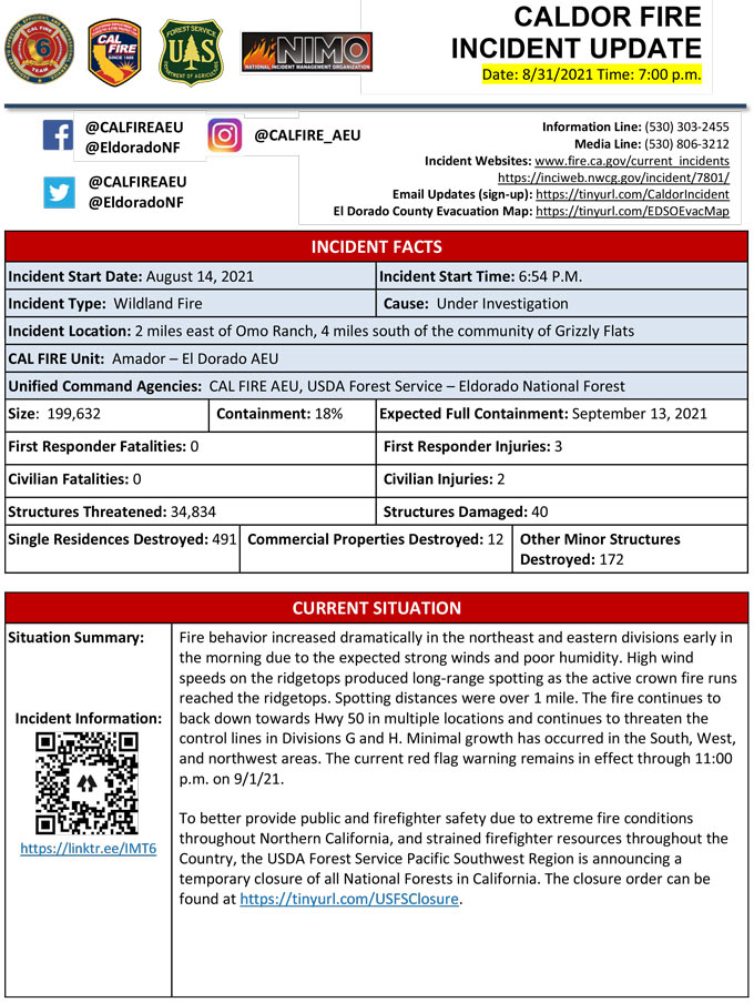
Evening Update Per CAL FIRE: California Caldor Fire is at 199,632 Acres, with 18% Containment, and 4,171 personnel assigned for Tuesday evening.
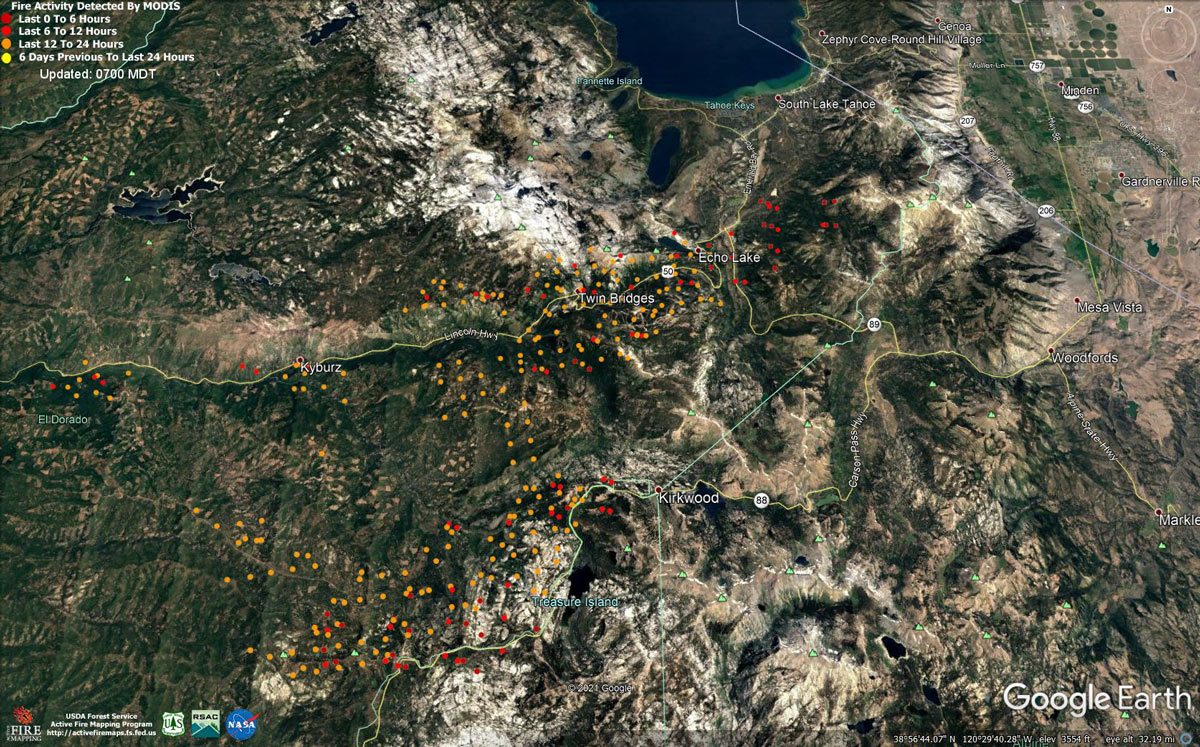
MODIS map of the Caldor Fire on Tuesday at 6:00 A.M PST
Note: 1,200 Pixels Wide - Note: Older Yellow not shown
MODIS Active Fire Mapping Program Frequently Asked Questions
Update: Caldor Fire Updates to Evacuation Orders, Warnings, and Road Closures for Tuesday, August 31, 2021
News: U.S. Senator Dianne Feinstein Releases Statement on Caldor Fire in California
Update: Smoke/Air Quality Outlook for the California Caldor Fire for Tuesday, August 31, 2021
Update: California Caldor Fire Infrared Map for Tuesday, August 31, 2021
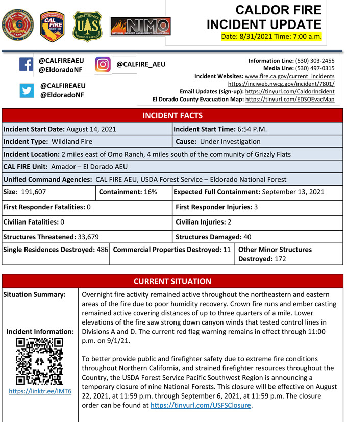
August 31, 2021 - Caldor Fire Update for Tuesday Morning, 191,607 Acres with 16% Containment.
Update CAL FIRE
Basic Information
| Current as of | 8/31/2021, 7:26:25 AM |
| Incident Type | Wildfire |
| Cause | Under Investigation |
| Date of Origin | Saturday August 14th, 2021 approx. 07:00 PM |
| Location | 4 miles South of Grizzly Flats, 2 miles East of Omo Ranch |
| Incident Commander | Jeff Veik, CAL FIRE IMT6 Joe Reinarz, USFS NIMO 2 |
| Coordinates | 38.584 latitude, -120.534 longitude |
Current Situation
| Total Personnel | 3,904 |
| Size | 191,607 Acres |
| Percent of Perimeter Contained | 16% |
| Estimated Containment Date | |
| Fuels Involved |
Heavy timber. Steep terrain. |
| Significant Events |
EL DORADO COUNTY MANDATORY EVACUATIONS ORDERS: ECHO / TAHOE BASIN AREA 083021 11:00 AM Heavenly • East of Pioneer Trail between Larch and Al Tahoe, to include the area of Heavenly Ski Resort out to the Alpine County Line and the Nevada State line on the East. Stateline • East of Ski run on the lake side of Pioneer Trail and also both sides of Pioneer Trail between Larch and the Nevada State line. 083021 10:00 AM Tahoe Keys • All residences with the Tahoe Keys community and all residents accessed from the streets connected to Tahoe Keys Blvd, staying east of 3rd Street. Tahoe Island • East of Highway 50/ Highway 89 at the at the Lake Tahoe Blvd and Highway 89 Highway 50 intersection. This includes the area of Barton Hospital and the area of Winnemucca to the “Y”. Also north of Highway 50 west of Tahoe Keys Blvd following along the north side of Highway 89 through the end of town prior to Pope Beach. Al Tahoe • All residences off of Lakeview which is west of Highway 50 North of Blue Lakes Road and east of Tahoe Keys Neighborhood. Sierra Tract • All residences on both sides of Highway 50 for the streets connected to O’Malley, Lodi, Silver Dollar and Rubicon Trail. Bijou • The residences between Al Tahoe on the east side of Johnson Blvd to include the streets of Treehaven and Fremont and extending to the east in to all residences west of Ski Run and east of Pioneer Trail. 083021 930 AM El Dorado County Tahoma • The section from Emerald Bay north to the Placer county line in Tahoma, extending west to the border of Desolation Wilderness. Fallen Leaf • The area from Sawmill Road at Lake Tahoe Blvd. extending north to Pope Beach. Along the water’s edge to Eagle Point. From Eagle Point west, to Desolation Wilderness, across Emerald Bay. Pioneer • This is the area North of Elks Club along Highway 50 and the West side of Pioneer Trail, also including the streets of Hekpa, excluding the residences west of the airport, this segment includes all residences accessed from Jicarilla, Washoan, and Glen Eagles. This also includes the Golden Bear neighborhood, and the neighborhoods of Cold Creek Trail, High Meadows, and Marshall Trail. Gardner Mountain • Northwest of the South Lake Tahoe Airport and west of the Highway 50 / Lake Tahoe Blvd and Highway 89 intersection to include the South Lake Tahoe High School, Tahoe Verde and the streets accessed from 5th through 15th street south of Highway 89 Trimmer • The area East of Pioneer Trail to the Alpine County Line stopping South of Heavenly Ski Resort, excluding all residence off of Pioneer Trail. EL DORADO COUNTY - MANDATORY EVACUATION ORDERS: (Evacuation areas are listed according to zones established by county and law enforcement agencies.* This corresponds to the Sheriff's Evacuation Map. ) North Camino to Ice House, North US 50 East of Forebay to Ice House, South Pollock & Camino Zone, East Sly Park to Ice House Rd, South Sly Park, Leisure, West Happy Valley, Happy Valley, Grizzly Flat West, Cole Station, West Omo, Omo South, Omo East, Omo Ranch Fill, Henry's Diggings, Leoni Meadows, Dogtown Creek, Big Mountain, Barney Ridge, Caldor, Greater Grizzly, Crystal Basin, US 50 South to Kyburz, Caples Creek, Mormon Emigrant Trail to HWY 88, Zone 4a, Zone 5a, Echo North, Echo South, Christmas Valley, Hell Hole, Washoe Meadows, Meyers, South Lake Tahoe EL DORADO COUNTY - EVACUATION WARNINGS: Dry Lakes, South of Wentworth Springs, Mosquito, Carson White Oak, Highway 50 South /Newton, Springer, Ant Hill, Mt. Aukum, Coyoteville 083021 3 pm - Downgraded from Mandatory • Pipi - East of North South Road from Omo Ranch to Cat Creek and east to Highway 88 1 mile east of Omo Ranch Road. • Cosumnes - This is a small section south of Farnham Ridge, north of the Amador/El Dorado County Line, and east of Bridgeport School Road. • Cement Hill - Cement Hill area, south of Omo Ranch south to Farnham Ridge Road • Farnham Ridge - The east end of Omo Ranch Road south to the Amador County Line AMADOR COUNTY - MANDATORY EVACUATIONS • Partial Zone 4/5: South of Highway 88 along the Amador/El Dorado County line from Dufrene Road, due east to the Amador/Alpine County line and from the Amador/Alpine County line north to Hwy 88. This includes Kirkwood Lake. AMADOR COUNTY - EVACUATION WARNINGS • Zone 3 – Western border is Highway 88 from Tiger Creek Road to Omo Ranch road intersection. North border is Highway 88 from Omo intersection to Panther Creek Road intersection. Eastern border is Ellis/Panther Creek road north to Highway 88. Southern border is Tiger Creek Road east to Salt Springs Reservoir Road and Ellis Road Intersection. •Partial Zone 4/5: South of the El Dorado-Amador County line with a western border of the Ellis/Panther Creek road. Southern border is the Salt Springs Reservoir road and the Amador/Calaveras County line. Eastern border is the Amador/Alpine County line. Northeast border is the line from Dufrene road east to Amador/Alpine County line. ALPINE COUNTY - MANDATORY EVACUATIONS • Highway 89 South from Luther Pass Road to the Pickets Junction (Highway 88). • West on Highway 88 to Kirkwood. ALPINE COUNTY - EVACUATION WARNING • Highway 88 at Forestdale Road. West of Forestdale Road and south to the Pacific Crest Trail Crossing. West of the Pacific Crest Trail to the Summit City Canyon Trail. West of Summit City Canyon Trail and south to the El Dorado / Stanislaus National Forest Line. El Dorado / Stanislaus National Forest Line west to the Alpine and Amador County line. • South of Armstrong Summit to Woodfords to Forestdale Road, north of Highway 88 and Highway 89 to Armstrong Summit. |
Outlook
| Projected Incident Activity |
Current Weather
| Weather Concerns |
Red Flag Warning for Gusty Winds and Low Relative Humidity in Effect from through 2300 Tuesday Evening. Observed: Winds remained gusty over the ridges through the night however very shallow inversions developed over the lower terrain and drainages. Low temperatures were 60-70. Maximum relative humidity reached only into the 25-30 percent range in the evening then fell into the upper teens overnight at many locations. Winds became downslope 2-6 mph with gusts to 15 mph below favored drainages. Over the ridges on the east end of the fire, winds remained southwest at 15-25 mph. Forecast for Tuesday: Windy with strong gusts and low relative humidity. Downslope and downcanyon winds ending by 0800 in lower drainages otherwise becoming wind to very windy. Ridgeline wind gusts to 40-45 mph can be expected over the east and northeast edges of the fire with speeds not as high over the lower ridges. Over the west side of the fire expect southwest winds 12-17 mph with gusts to 25 mph through the day. Highs 77-87 higher elevations and 87-97 lower elevations. Min humidity...10-15 percent. |
Click here for: California Caldor Fire Monday, August 30, 2021 Updates
