


Note: Click here for Caldor Fire Sunday Updates
Update: Caldor Fire Virtual Briefing & Community Meeting Evening Update Video for Saturday, September 4, 2021
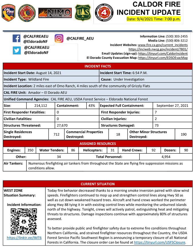
Evening Update Per CAL FIRE: California Caldor Fire is at 214,112 Acres, with 43% Containment, and 4,954 personnel assigned for Saturday evening.
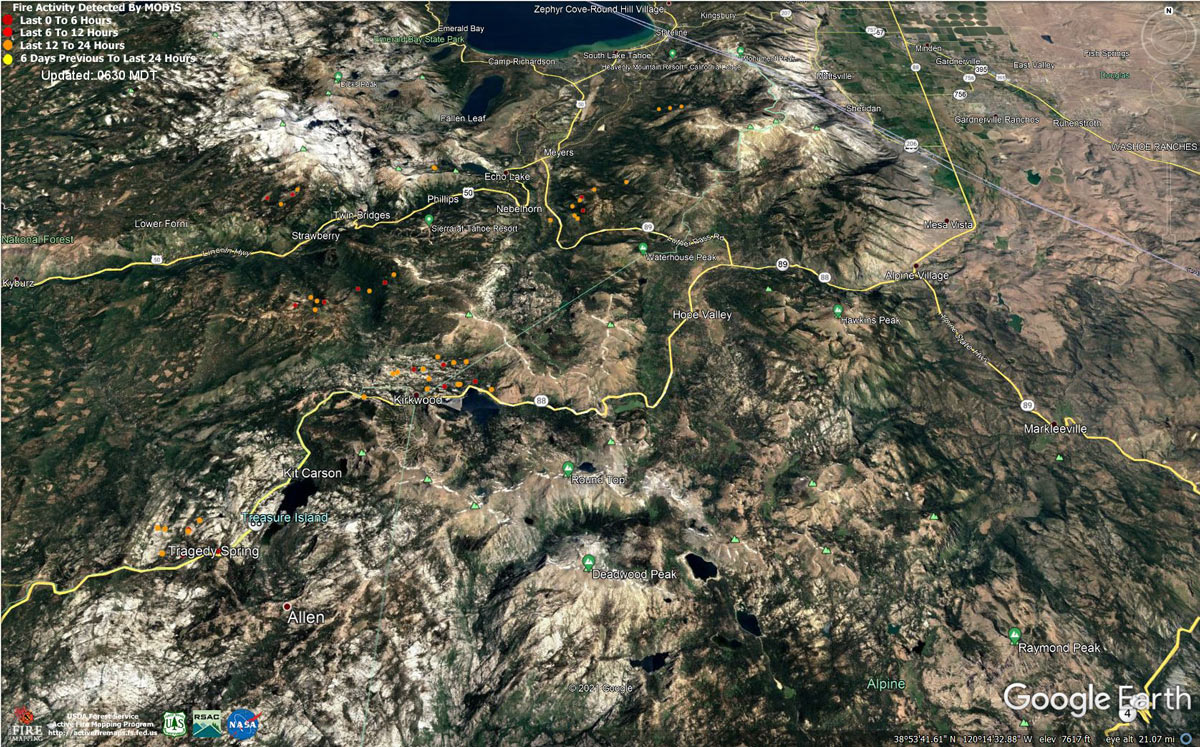
MODIS map of the Caldor Fire on Saturday at 5:30 A.M PST
Note: 1,200 Pixels Wide - Note: Older Yellow not shown
MODIS Active Fire Mapping Program Frequently Asked Questions
Update: Caldor Fire Virtual Community Meeting Set for 5:00 P.M. Tonight, September 4, 2021
Update: Caldor Fire Returning Home After Wildfire - Video and Information from CAL FIRE
Update: Caldor Fire Operations Briefing Video for Saturday Morning, September 4, 2021
Update: Smoke/Air Quality Outlook for the California Caldor Fire for Saturday, September 4, 2021
Update: California Caldor Fire Infrared Map for Saturday, September 4, 2021
September 4, 2021 - Caldor Fire Update for Saturday Morning, 214,107 Acres with 37% Containment.
Update CAL FIRE

Basic Information
| Current as of | 9/4/2021, 6:54:16 AM |
| Incident Type | Wildfire |
| Cause | Under Investigation |
| Date of Origin | Saturday August 14th, 2021 approx. 07:00 PM |
| Location | 4 miles South of Grizzly Flats, 2 miles East of Omo Ranch |
| Incident Commander | Jeff Veik, CAL FIRE IMT6; Joe Reinarz, USFS NIMO 2; Rocky Oplinger, ICT1, USFS CIIMT4 |
| Coordinates | 38.584 latitude, -120.534 longitude |
Current Situation
| Total Personnel | 4,662 |
| Size | 214,107 Acres |
| Percent of Perimeter Contained | 37% |
| Estimated Containment Date | Monday September 13th, 2021 approx. 06:00 PM |
| Fuels Involved |
Heavy timber. Steep terrain. |
| Significant Events |
REMINDER: There is still a temporary Emergency Closure in effect for the Eldorado National Forest through the end of September. This closure includes all National Forest lands, roads and trails within the Eldorado National Forest. See Forest Order 03-21-14 for more information. The Lake Tahoe Basin Management Unit is closed under the Regional Emergency Closure of all National Forests in California. See the Regional Order for more information. Recreation residence and other permittees should contact their permit administrator for questions regarding access when their area becomes open for repopulation. --- *Evacuation areas are listed according to zones established by the respective county and law enforcement agencies. Full descriptions are available on county websites. DOUGLAS COUNTY, NV EVACUATIONS ORDERS: Upper Kingsbury, Lower Kingsbury • Upper Kingsbury (South), Upper Kingsbury (North), Central Kingsbury, Lower Kingsbury, Lower Olivers, Kahle Drive region, and roads, Lake Village, areas south of Elks Point road. DOUGLAS COUNTY, NV EVACUATIONS WARNINGS: Douglas Zone 2 • Zone 2: Any homes or property located on Foothill Road from Centerville Lane north to Muller. Included in this zone is the valley side of Kingsbury Grade and any homes that are accessed by Foothill Road between Centerville Lane and Muller Lane. ALPINE COUNTY EVACUATION ORDERS: • Zones 19, 20, 21A, and 22A ALPINE COUNTY WARNINGS: • Zones 23, 21B, and 22B EL DORADO COUNTY ORDERS: Forebay to Ice House, East Sly Park, South Sly Park, Henry's Diggings, Leoni Meadows, Dogtown Creek, Big Mountain, Caldor, Greater Grizzly, Grizzly Flat Proper, Crystal Basin, US 50 South to Kyburz, Caples Creek, Mormon Emigrant Trail to HWY 88, Echo North, Echo South, Christmas Valley, Hell Hole, Washoe Meadows, Meyers, Tahoe Island, Tahoe Keys, Sierra Tract, Al Tahoe, Bijou, Heavenly, Stateline, Tahoma, Fallen Leaf, Trimmer, Pioneer, Gardner Mountain, Desolation, Desolation North, Desolation East. EL DORADO COUNTY WARNINGS: Dry Lakes, South of Wentworth Springs, Highway 50 South/Newtown, Springer, Ant Hill, Pi Pi, North Camino, West Omo, Omo South, Omo East, Barney Ridge. The evacuation order for El Dorado County, Central Pollock Pines area has been reduced to a warning. The area described as South of US highway 50, North of Starkes Grade Road, East of Snows Road and West of Fresh Pond. The evacuation order for El Dorado County, South Sly Park, has been reduced to a warning - The area described as south of Starkes Grade Road, north of Sly Park Creek, east of Pleasant Valley Road up to and including the Diamond Garnet subdivision.-Outside the fire line. The evacuation order for El Dorado County, Leisure Zone has been reduced to a warning. The area described as South of Pleasant Valley between Bucks Bar Road and Newtown Road, East of Bucks Bar Road to Mt. Aukum Road. This includes the area of Gopher Hole Road and Moonshadow. The evacuation order for El Dorado County, Grizzly Flats West, has been reduced to a warning. The area described as East of Highway E16, west of Steely Ridge Road, South of the North Fork of the Cosumnes River and North of the Middle Fork of the Cosumnes River - Outside the fireline. The evacuation order for El Dorado County, Happy Valley, has been reduced to a warning. The area described as all properties accessed from Happy Valley Road -Outside the fire line. AMADOR COUNTY ORDERS: Zone 4a and 5a AMADOR COUNTY WARNINGS: Zones 3, 4b, 5b |
Outlook
| Planned Actions |
WEST ZONE: Provide for the life safety of citizens and emergency responders. Implement structure and critical infrastructure defense. Construct control lines and take advantage of targets of opportunity as allowed by fire behavior and resource limitations. Improve and hold established control lines. Prepare for firing operations and implement burn plans. Identify and establish contingency lines. Tactical patrol of perimeter contained. EAST ZONE: In the Christmas Valley area crews are continuing to construct direct containment lines from Highway 89 west to Scout Peak to reduce the threat to structures. In the Pioneer Trail area, resources will patrol and mop up as needed. On the northeastern side of the fire in the Cold Creek Drainage area, resources will continue to use a combination of direct and indirect tactics, working with local utility companies to open road systems to connect to dozer line to stem continued fire spread to the northeast. On the southern flank of the eastern finger of the fire, a combination of hand and dozer line will be used to keep fire from moving to the south and east. On the northwest part of the zone, crews will continue to construct direct fireline from Highway 50 toward Lower Echo Lake. In the Lower and Upper Echo Lake areas, structure defense operations will continue. A contingency group is locating and building contingency lines to the northeast of the fire in the event of fire crossing primary containment lines. Mastication is occurring on road systems south of the east zone of the fire. Planning is occurring to mitigate potential threat to communities in the Foothill Road area. |
| Projected Incident Activity |
Current Weather
| Weather Concerns |
WEST ZONE: Observed: Clear with areas of smoke. Inversions set in after 2000 and persisted through the night. 48-55 highest elevations to 56-63 lower elevations. Humidity recovery poor at 23-28 percent. Winds were downslope/downcanyon 4-9 mph with gusts to 13 mph in deepest drainages. Forecast: High pressure will remain over the fire area through Sunday with inversion conditions, low relative humidity with poor recoveries and warming temperatures. Increased ridge winds will return by Monday and an overall uptick in winds will occur early next week. EAST ZONE: Observations: Strong inversions formed overnight with very poor humidity recoveries Satuonly reaching 20 to 30% along the mid-slopes and ridgelines. Good recoveries occurred in the lower valleys with temperatures in the 30's in the lowest elevations. Ridge winds generally remained out of the southeast gusting to around 20 mph with lighter downslope terrain driven winds over the rest of the fire area. Saturday Forecast: Extremely dry air will remain over the fire area on Saturday with a warming trend continuing through the weekend as high pressure builds over the west. Humidities will drop into the low to mid-teens at all elevations again during the day with very poor recoveries on mid-slopes and ridges. Ridge winds will remain generally out of the southeast 10 to 15 mph with clearer smoke conditions on the east side of the fire. Surface winds remain generally terrain driven with upslope winds 4 to 8 mph during the afternoon and gusts up to 15 mph in canyons. |
Click here for: California Caldor Fire Friday, September 3, 2021 Updates
