
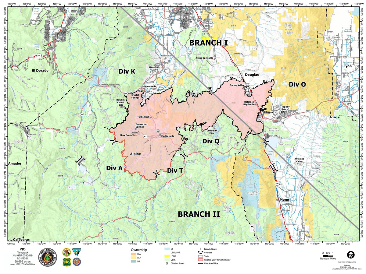
Map for Saturday, July 31, 2021
Note: 1,200 Pixels Wide
Evening Update: The Tamarack Fire as of Saturday evening is now at 68,696 Acres with 82% Containment.
Basic Information
| Current as of | 7/31/2021, 5:38:54 PM |
| Incident Type | Wildfire |
| Cause | Lightning |
| Date of Origin | Sunday July 04th, 2021 approx. 04:00 PM |
| Location | 16 Miles south of Gardnerville, NV |
| Incident Commander | Dan Dallas, IC Bill Hahnenberg, Deputy IC |
| Incident Description | This Incident Continues To Be Managed With A Full Suppression Strategy, However Steep Inaccessible Terrain In Division Alpha Necessitates A Suppression Strategy Of Confinement. |
| Coordinates | 38.628 latitude, -119.857 longitude |
Current Situation
| Total Personnel | 582 |
| Size | 68,696 Acres |
| Percent of Perimeter Contained | 82% |
| Estimated Containment Date | Tuesday August 31st, 2021 approx. 12:00 AM |
| Fuels Involved |
Timber (Grass and Understory) Chaparral (6 feet) Timber (Litter and Understory) |
| Significant Events |
Active Backing Creeping Smoldering Fire is burning in mixed conifer, Pinyon Juniper and brush fuel types, with creeping and smoldering. Single tree torching possible. |
Outlook
| Planned Actions |
Branch I - Keep fire south of China Spring and west of Highway 395. Keep fire south of Highway 88 and east of Blue Lake Road. Continue right sizing organization. Branch II - Keep fire north of Highway 89 (Monitor pass) and Hwy 4. Continue right sizing organization. Structure - Secure structures in all branches. Continue right sizing organization. Night Operations - Patrol and secure structures in all branches. |
| Projected Incident Activity |
12 hours: Primarily creeping and smoldering fire. 24 hours: Creeping fire with smoldering and little movement. |
| Remarks |
Acreage estimated from FireWatch flight on 7/29/2021 at 1322. Steep rugged terrain in Division Alpha necessitates a suppression strategy of confinement. Perimeter in Division Alpha represents 15% of the total fire perimeter. The remaining perimeter (85%) will be fully contained using full suppression tactics. |
Current Weather
| Weather Concerns |
Today's weather was mostly cloudy with numerous thunderstorms in the area. Some rain fell on the fire area along with gusty outflow winds. High Temps 72-84. Min RH 30-45%. Upslope 4-8 mph with WSW 8-13 G20 in the afternoon and evening. HAINES 3, LAL 3 CWR 40%. Tonight-Partly cloudy. Min Temp 50-60. Max humidity around 55-70%. Light winds, localized breezy down canyon winds. Sunday-Mostly cloudy with scattered wet thunderstorms. Heavy rainfall is possible. High Temps 72-84. Min RH 30-45%. Upslope 4-8 mph with WSW 8-13 G20 in the afternoon and evening. HAINES 3, LAL 3 CWR 25%. |
Update: Tamarack Fire Operations Briefing Video for Saturday, July 31, 2021
Update: Smoke/Air Quality Outlook for the Tamarack Fire in Alpine County for Saturday, July 31
July 31, 2021 - The Tamarack Fire as of Saturday morning is now at 68,696 Acres with 79% Containment.
Tamarack Fire Daily Update July 31, 2021 (pdf 232 kb)
Tamarack Fire Update
Saturday, July 31, 2021 – 9:00 a.m.
Rocky Mountain Type 1 Incident Management Team
Dan Dallas, Incident Commander
Information Phones: 775-434-8629 (public)
775-434-8110 (media only – ends after today)
Email: 2021.tamarack@firenet.gov
Information Staffing Hours: 8 a.m. to 8 p.m.
Special notes:
Power companies will be flying in new utility poles by helicopter today. They are working near Markleeville in the Turtle Rock corridor. State Route 89 will be periodically closed for them to operate safely.
Current Situation:
Firefighters fully contained Division Q yesterday, adding new containment line between Leviathan Creek and the Carson River. The fire is now 79% contained.
The suppression repair group continues work today based on priority actions from local natural and cultural resource advisors. Crews and excavators rehabilitated areas near Markleeville, Woodfords, and Crystal Springs yesterday. Today they plan to finish chipping along State Route 89.
The structure and night operations groups are responding to homeowner reports of smoke. They put out one new lightning-started fire near Woodfords last night and will check for other new starts today. Smoke and spots within the fire perimeter are protected by the containment line. Fire equipment and personnel will decrease as the incident meets objectives and the current team prepares to transition.
Branch I:
Divisions K and O – The north and east edges of the fire are contained and in patrol status. Three crews addressed hot spots in Division K, focusing on the area east of Hawkins communication site and Burnside Lake.
Branch II:
Division Q and T – The UAS flew the edge of Division Q yesterday to ensure the line is secure. With containment complete, crews will patrol today. In Division T, hotshots completed hazard tree removal near residences yesterday. The focus for containment today is the area that firefighters burned out on the ridge above English Meadow.
Division A –Yesterday, a third camera was added to this division that can be viewed live and remotely controlled by fire managers. This camera will enable fire officials to see specific areas of concern that they may be able to quell with additional suppression tactics. Two wildland fire modules remain in this division. Due to extremely rugged terrain and minimal fire activity, this division is being managed for confinement to maximize firefighter safety and utilize natural barriers to fire spread. Confinement means that firefighters will take requisite action to minimize risks to life and safety. Natural barriers and limited fuels will serve to prevent fire spread and potential.
Weather and Fuel Conditions:
Storms brought heavy rain to parts of the fire area yesterday. There was a flood advisory on the eastern edge of the fire yesterday. Today another flash flood watch is in effect with more heavy rain, lightning, and storms expected. Beware of rockslides, mud slides, or debris flows. Less rain is forecast tomorrow. Monday will be dry and windy.
Evacuations, Recovery, Closures, and Fire Restrictions:
For evacuation and recovery information in Alpine and Douglas Counties visit: https://bit.ly/2V5tT8H and https://bit.ly/3le3PmE. For closures and fire restrictions on National Forest lands visit: https://www.fs.usda.gov/alerts/htnf/alerts-notices. Grover Hot Springs State Park remains closed to the public.
Temporary Flight Restriction (TFR):
A temporary flight restriction (TFR) remains in place. TFR violations can disrupt aerial firefighting operations and may force fire managers to ground essential aircraft. Wildfires are a no-fly zone for unauthorized aircraft, including drones. If you fly, we can’t. For more information, visit http://knowbeforeyoufly.org.
Click here for: Tamarack Fire in Alpine County Updates for Friday, July 30, 2021