


Map for Friday, July 30, 2021
Note: 1,200 Pixels Wide
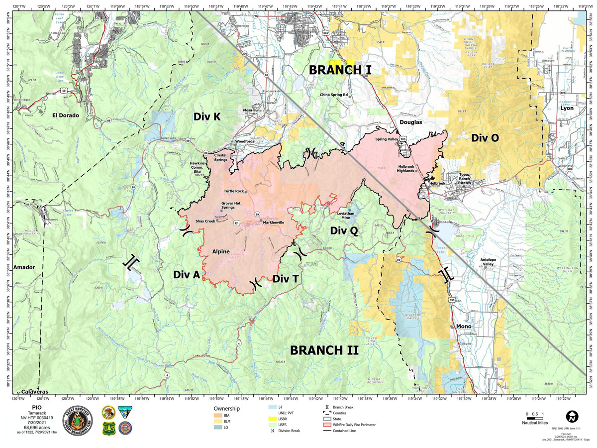
Evening Update: The Tamarack Fire as of Friday evening is now at 68,696 Acres with 79% Containment.
Basic Information
| Current as of | 7/30/2021, 6:01:12 PM |
| Incident Type | Wildfire |
| Cause | Lightning |
| Date of Origin | Sunday July 04th, 2021 approx. 04:00 PM |
| Location | 16 Miles south of Gardnerville, NV |
| Incident Commander | Dan Dallas, IC Bill Hahnenberg, Deputy IC |
| Coordinates | 38.628 latitude, -119.857 longitude |
Current Situation
| Total Personnel | 679 |
| Size | 68,696 Acres |
| Percent of Perimeter Contained | 79% |
| Estimated Containment Date | Tuesday August 31st, 2021 approx. 12:00 AM |
| Fuels Involved |
Timber (Grass and Understory) Chaparral (6 feet) Timber (Litter and Understory) |
| Significant Events |
Active Flanking Backing Fire is burning in mixed conifer, Pinyon Juniper and brush fuel types, with active spread still possible. Single tree torching possible. |
Outlook
| Planned Actions |
Branch I - Keep fire south of China Spring and west of Highway 395. Keep fire south of Highway 88 and east of Blue Lake Road. Initiate suppression repair. Continue right sizing organization. Branch II - Keep fire north of Highway 89 (Monitor pass) and Hwy 4. Continue right sizing organization. Structure - Secure structures in all branches. Continue right sizing organization. Night Operations - Patrol and secure structures in all branches. |
| Projected Incident Activity |
12 hours: Primarily backing and flanking fire. 24 hours: Creeping fire with smoldering and little movement. |
| Remarks |
Acreage estimated from FireWatch flight on 7/29/2021 at 1322. |
Current Weather
| Weather Concerns |
Today's weather was mostly cloudy with numerous thunderstorms in the area. Some rain fell on the fire area along with gusty outflow winds. High Temps 72-84. Min RH 30-45%. Upslope 4-8 mph with WSW 8-13 G20 in the afternoon and evening. HAINES 3, LAL 4 CWR 40%. Tonight-Partly cloudy. Min Temp 50-60. Max humidity around 55-70%. Light winds, localized breezy down canyon winds. Saturday-Mostly cloudy with numerous wet thunderstorms. Heavy rainfall is possible. High Temps 72-84. Min RH 30-45%. Upslope 4-8 mph with WSW 8-13 G20 in the afternoon and evening. HAINES 3, LAL 4 CWR 50%. |
Update: Bentley Ranch Provide Location for Burnt Veg. 7-30 (pdf 191 kb)
Update: Tamarack Fire Operations Briefing Video for Friday, July 30, 2021
Update: Alpine County Lifting Some Mandatory Evacs. 7-30 (pdf 146 kb)
Update: Smoke/Air Quality Outlook for the Tamarack Fire in Alpine County for Friday, July 30
July 30, 2021 - The Tamarack Fire as of Friday morning is now at 68,696 Acres with 65% Containment.
Friday, July 30, 2021 – 9:00 a.m.
Rocky Mountain Type 1 Incident Management Team
Dan Dallas, Incident Commander
Information Phones: 775-434-8629 (public)
Email: 2021.tamarack@firenet.gov
Information Staffing Hours: 8 a.m. to 8 p.m.
Special notes:
Forest officials on the Humboldt-Toiyabe National Forest will reopen the section of the Pacific Crest Trail (PCT) between State Route 88 and State Route 4 (Ebbetts Pass), that was closed for public safety, after midnight tonight. Because of firefighting operations east of the PCT, hikers should be cautious and hike directly through the area, staying on the trail.
Current Situation:
Firefighters added approximately six miles of new containment line yesterday in the eastern portion of Division Q between Leviathan Peak and Leviathan Mine Road. The fire is now 65% contained. Firefighters continue to work around the clock to increase containment and patrol and mop up contained areas. Storms yesterday brought light, steady rain throughout the fire area. A flash flood watch is in effect from 12pm to 7pm today.
While the fire suppression effort continues, backhauling has started. Backhauling is the process of removing equipment no longer needed from the fire area. Generators, hoses and pumps, and portable water tanks are then reconditioned and made available for use on other fires. Suppression repair continues today. Fire staff are coordinating with CalTrans for safe chipping operations along SR 89. Chipping brush that was cut during fire line construction can spread out the piles of fuel. The spread-out chips can reduce erosion by catching or slowing water runoff. Additionally, the forest has ordered resources to support and begin Burned Area Emergency Response (BAER) assessments.
Branch I: Divisions K and O – The entire north and east edges of the fire are contained and in patrol status. On the western edge, crews addressed hot spots in heavy timber east of Hawkins communication site. They continue operations near Charity Valley Creek to fully contain the remaining line north of the Division A break.
Branch II: Division Q – Crews secured new containment line yesterday. Today they will continue working west of Leviathan Mine Road toward Mogul Canyon, igniting fuels by hand to tie together the uneven fire edge and strengthen containment lines. The suppression repair group started chipping yesterday along Leviathan Mine Road.
Division T – Firefighters continue to mop up the part of this division where firing operations occurred on Wednesday. Their focus is on finding and extinguishing hotspots adjacent to the line. The fire in steep, mixed-conifer forest spread unevenly. This can make it harder to establish full containment.
Division A – Two wildland fire modules are assigned to this division that is in steep, rugged terrain. The fire is not moving in this area and is confined by rocky terrain and limited fuels. Natural barriers are limiting fire spread and potential.
Weather and Fuel Conditions:
The chance of wetting rain increases today and tomorrow. Heavy rain in a burned area can trigger rockslides, mud slides, or debris flows. Debris flows are fast-moving landslides that can destroy objects in their paths, and often strike without warning. They can travel at speeds exceeding 35 mph and can carry large items like boulders, trees, and cars. If a debris flow enters a steep stream channel, it can travel for several miles.
Evacuations, Recovery, Closures, and Fire Restrictions:
For evacuation and recovery information in Alpine and Douglas Counties visit: https://bit.ly/2V5tT8H and https://bit.ly/3le3PmE
For closures and fire restrictions on National Forest lands visit: https://www.fs.usda.gov/alerts/htnf/alerts-notices
Grover Hot Springs State Park remains closed to the public. As of today, Burnside Lake is no longer under evacuation.
Click here for: Tamarack Fire in Alpine County Updates for Thursday, July 29, 2021
