


Map for Thursday, July 29, 2021
Evening Update: The Tamarack Fire as of Thursday evening is now at 68,696 Acres with 65% Containment.
Basic Information
| Current as of | 7/29/2021, 5:44:35 PM |
| Incident Type | Wildfire |
| Cause | Lightning |
| Date of Origin | Sunday July 04th, 2021 approx. 04:00 PM |
| Location | 16 Miles south of Gardnerville, NV |
| Incident Commander | Dan Dallas, IC Bill Hahnenberg, Deputy IC |
| Coordinates | 38.628 latitude, -119.857 longitude |
Current Situation
| Total Personnel | 813 |
| Size | 68,696 Acres |
| Percent of Perimeter Contained | 65% |
| Estimated Containment Date | Tuesday August 31st, 2021 approx. 12:00 AM |
| Fuels Involved |
Timber (Grass and Understory) Chaparral (6 feet) Timber (Litter and Understory) |
| Significant Events |
Active Uphill Runs Flanking Backing Fire is burning in mixed conifer, Pinyon Juniper and brush fuel types, with active spread still possible. Torching, and running fire behavior with shortrange spotting. |
Outlook
| Planned Actions |
Branch I - Keep fire south of China Spring and west of Highway 395. Keep fire south of Highway 88 and east of Blue Lake Road. Initiate suppression repair. Continue right sizing organization. Branch II - Keep fire north of Highway 89 (Monitor pass) and Hwy 4. Continue right sizing organization. Structure - Secure structures in all branches. Continue right sizing organization. Night Operations - Patrol and secure structures in all branches. |
| Projected Incident Activity |
12 hours: Primarily backing and flanking fire. 24 hours: Fire spread is primarily backing and flanking to the south. |
| Remarks |
Acreage estimated from FireWatch flight on 7/29/2021 at 1322. |
Current Weather
| Weather Concerns |
Today's weather was mostly cloudy with numerous thunderstorms in the area. Some rain fell on the fire area along with gusty outflow winds. High Temps 72-84. Min RH 30-45%. Upslope 4-8 mph with WSW 8-13 G20 in the afternoon and evening. HAINES 3, LAL 4 CWR 40%. Tonight-Partly cloudy. Min Temp 50-60. Max humidity around 55-70%. Light winds, localized breezy down canyon winds. Friday-Mostly cloudy with numerous wet thunderstorms. Heavy rainfall is possible. High Temps 72-84. Min RH 30-45%. Upslope 4-8 mph with WSW 8-13 G20 in the afternoon and evening. HAINES 3, LAL 3 CWR 25%. |
Update - Liberty Update for July 30, 2021: Liberty update for July 30th (it's a shorty): Liberty is prepared to power Coleville/Walker with a temporary generator if necessary while NV Energy repairs its lines damaged in the Tamarack Fire.
Update: Portion of Pacific Crest Trail Reopens July 31, 21 (pdf 193 kb)
Update: Tamarack Fire Operations Briefing Video for Thursday, July 29, 2021
Update: Smoke/Air Quality Outlook for the Tamarack Fire in Alpine County for Thursday, July 29
Update: California Governor Newsom Surveys Tamarack Fire Damage with Nevada Governor Sisolak, Meets with Fire and Emergency Officials at Incident Command Center
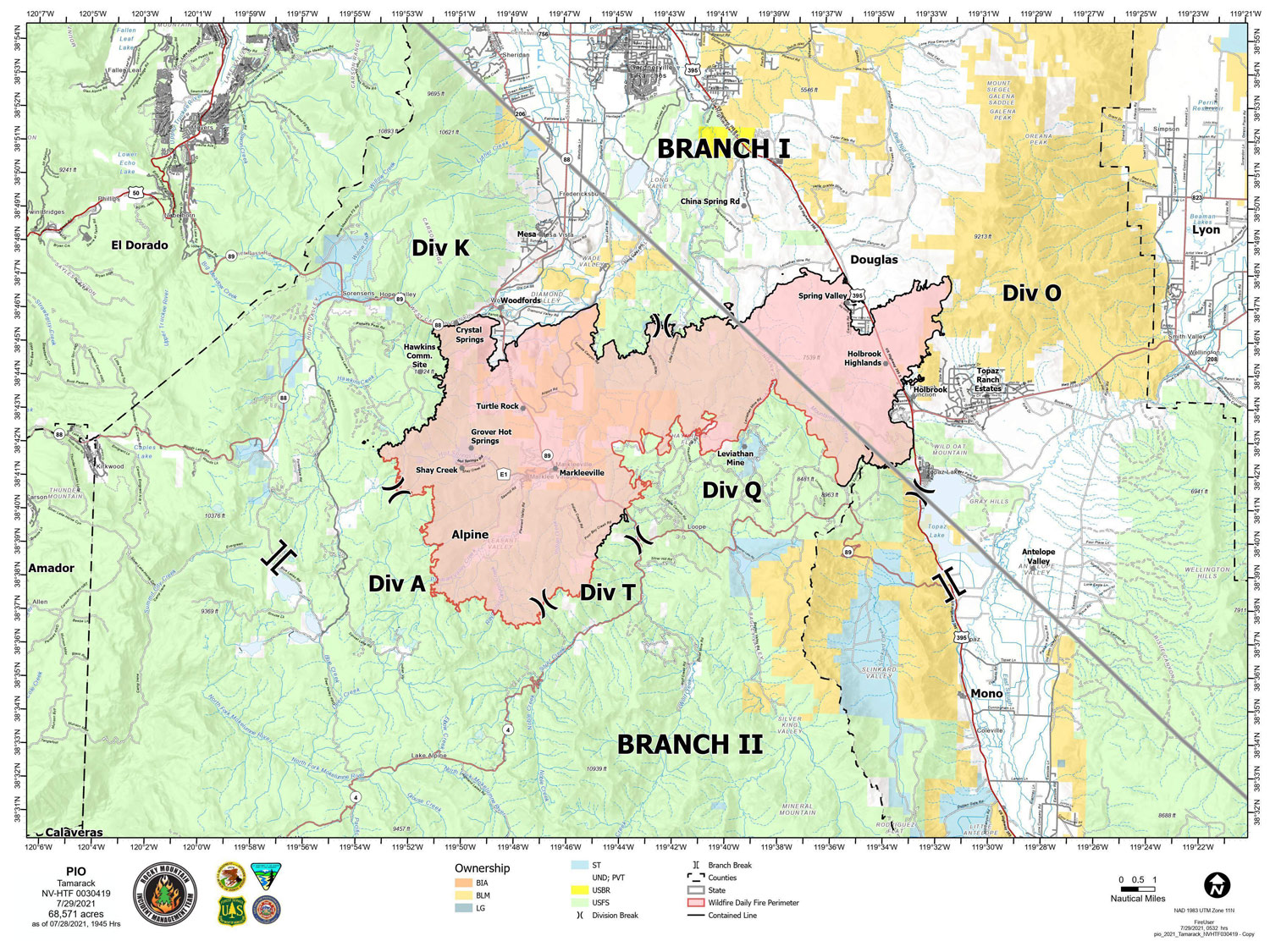
Basic Information
| Current as of | 7/29/2021, 6:26:47 AM |
| Incident Type | Wildfire |
| Cause | Lightning |
| Date of Origin | Sunday July 04th, 2021 approx. 04:00 PM |
| Location | 16 Miles south of Gardnerville, NV |
| Incident Commander | Dan Dallas, IC Bill Hahnenberg, Deputy IC |
| Coordinates | 38.628 latitude, -119.857 longitude |
Current Situation
| Total Personnel | 1,093 |
| Size | 68,571 Acres |
| Percent of Perimeter Contained | 59% |
| Estimated Containment Date | Tuesday August 31st, 2021 approx. 12:00 AM |
| Fuels Involved |
Timber (Grass and Understory) Chaparral (6 feet) Timber (Litter and Understory) |
| Significant Events |
Active Uphill Runs Flanking Fire is burning in mixed conifer, Pinyon Juniper and brush fuel types, with active spread still possible. Torching, and running fire behavior with shortrange spotting. |
Outlook
| Planned Actions |
Branch I - Keep fire south of China Spring and west of Highway 395. Keep fire south of Highway 88 and east of Blue Lake Road. Initiate suppression repair. Continue right sizing organization. Branch II - Keep fire north of Highway 89 (Monitor pass) and Hwy 4. Continue right sizing organization. Structure - Secure structures in all branches. Continue right sizing organization. Night Operations - Patrol and secure structures in all branches. |
| Projected Incident Activity |
12 hours: Primarily backing and flanking fire. 24 hours: Fire spread is primarily backing and flanking to the south. |
| Remarks |
Acreage estimated from IR flight on 7/27/2021 at 1940. |
Current Weather
| Weather Concerns |
Today's weather was mostly cloudy with numerous thunderstorms in the area. Some rain fell on the fire area along with gusty outflow winds. High Temps 72-84. Min RH 30-45%. Upslope 4-8 mph with WSW 8-13 G20 in the afternoon and evening. HAINES 3, LAL 4 CWR 40%. Tonight-Partly cloudy. Min Temp 50-60. Max humidity around 55-70%. Light winds, localized breezy down canyon winds. Thursday-Mostly cloudy with numerous thunderstorms. Heavy rainfall is possible. High Temps 72-84. Min RH 30-45%. Upslope 4-8 mph with WSW 8-13 G20 in the afternoon and evening. HAINES 3, LAL 3 CWR 25%. |
Click here for: Tamarack Fire in Alpine County Updates for Wednesday, July 28, 2021
