


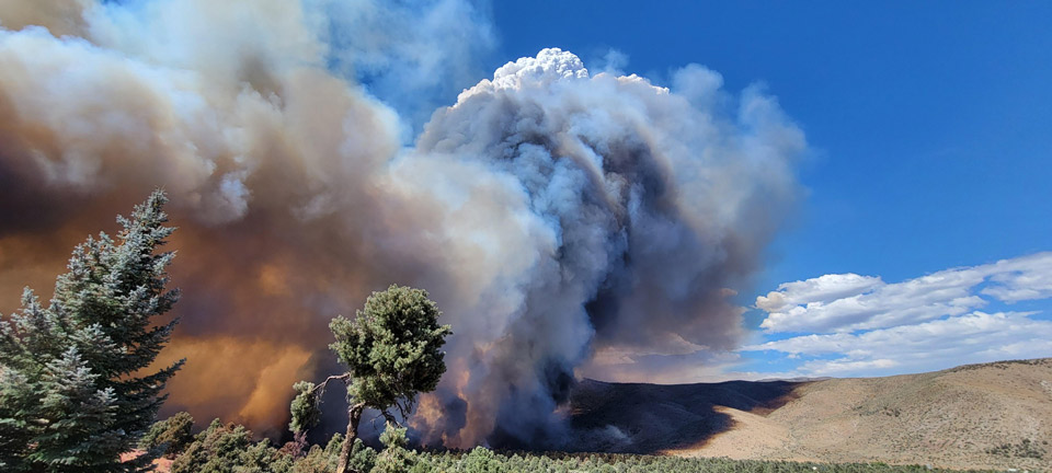
Hwy. 395 area on the afternoon of July 22
Credit: USFWS
Evening Update: The Tamarack Fire as of Wednesday evening is now at 68,497 Acres with 59% Containment.
Basic Information
| Current as of | 7/28/2021, 6:07:14 PM |
| Incident Type | Wildfire |
| Cause | Lightning |
| Date of Origin | Sunday July 04th, 2021 approx. 04:00 PM |
| Location | 16 Miles south of Gardnerville, NV |
| Incident Commander | Dan Dallas, IC Bill Hahnenberg, Deputy IC |
| Coordinates | 38.628 latitude, -119.857 longitude |
Current Situation
| Total Personnel | 1,093 |
| Size | 68,497 Acres |
| Percent of Perimeter Contained | 59% |
| Estimated Containment Date | Tuesday August 31st, 2021 approx. 12:00 AM |
| Fuels Involved |
Timber (Grass and Understory) Chaparral (6 feet) Timber (Litter and Understory) |
| Significant Events |
Active Uphill Runs Flanking Fire is burning in mixed conifer, Pinyon Juniper and brush fuel types, with active spread still possible. Torching, and running fire behavior with shortrange spotting. |
Outlook
| Planned Actions |
Branch I - Keep fire south of China Spring and west of Highway 395. Keep fire south of Highway 88 and east of Blue Lake Road. Initiate suppression repair. Continue right sizing organization. Branch II - Keep fire north of Highway 89 (Monitor pass) and Hwy 4. Continue right sizing organization. Structure - Secure structures in all branches. Continue right sizing organization. Night Operations - Patrol and secure structures in all branches. |
| Projected Incident Activity |
12 hours: Primarily backing and flanking fire. 24 hours: Fire spread is primarily backing and flanking to the south. |
| Remarks |
Acreage estimated from IR flight on 7/27/2021 at 1940. |
Current Weather
| Weather Concerns |
Today's weather was mostly cloudy with numerous thunderstorms in the area. Some rain fell on the fire area along with gusty outflow winds. High Temps 72-84. Min RH 30-45%. Upslope 4-8 mph with WSW 8-13 G20 in the afternoon and evening. HAINES 3, LAL 4 CWR 40%. Tonight-Partly cloudy. Min Temp 50-60. Max humidity around 55-70%. Light winds, localized breezy down canyon winds. Thursday-Mostly cloudy with numerous thunderstorms. Heavy rainfall is possible. High Temps 72-84. Min RH 30-45%. Upslope 4-8 mph with WSW 8-13 G20 in the afternoon and evening. HAINES 3, LAL 3 CWR 25%. |
Update 6:15 P.M. Liberty update for 7/29.
- Generators are being set up for Coleville/Walker customers at the request of NV Energy for load curtailment while they repair their lines damaged in the Tamarack Fire. Customers may experience a short outage tonight or tomorrow morning while transferring over to generator power.
- We will provide more information when the generator is being started once available.
- Liberty has an updated schedule for a helicopter to set poles and string wire in difficult terrain for Saturday-Monday.
Most recent updates: https://california.libertyutilities.com/north-lake-tahoe/residential/emergencies/electrical/outages-map.html
Update 8:35 A.M. Per Cal Trans; ALPINE COUNTY – The California Department of Transportation (Caltrans) and the California Highway Patrol (CHP) reopened State Routes 4 and 89 in Alpine County to through-traffic only at 7:00 a.m. on Wednesday, July 28, 2021.
There will be no access to the United States Forest Service (USFS) lands.
Be advised firefighting work on the Tamarack Fire is still being done in many areas. Best to avoid the area, but if you must travel, use caution and reduce speeds on roadways as firefighting vehicles will also be sharing the road. Additionally, utility companies will work to restore services and repair damaged equipment.
These repairs may require road closures up to 2 hours and without notice. These repairs are scheduled from 10:00 a.m. to 10:00 p.m., beginning Saturday, July 31, through Monday, August 2, 2021.
Update 8:15 A.M. Evacuation Lifted and Road Closure Update (pdf 146 kb)
Updates: Smoke/Air Quality Outlook for the Tamarack Fire in Alpine County for Wednesday, July 28
July 28, 2021 - The Tamarack Fire as of Wednesday morning is now at 68,393 Acres with 59% Containment.
Tamarack Fire Update
Wednesday, July 28, 2021 – 9:00 a.m.
Rocky Mountain Type 1 Incident Management Team
Dan Dallas, Incident Commander
Information Phones: 775-434-8629 (public), 775-434-8110 (media only)
Email: 2021.tamarack@firenet.gov
Information Staffing Hours: 8 a.m. to 8 p.m.
Special notes: A recording of the public fire information briefing held last night can be viewed on Facebook under video at www.facebook.com/tamarackfireinfo or on YouTube at https://bit.ly/TamarackVideo. People are getting back into their homes and back on the roads. Please limit travel to essential travel on the roads near and through the fire area. There is still heavy firefighter traffic in the area and firefighters working along the roadways. Help us keep our firefighters safe.
Current Situation: Firefighters made more progress yesterday securing the fire perimeter. Containment is now at 59%. Caltrans lifted the remaining highway closures along State Routes 4 and 89 this morning. Forest closure orders remain in place and many roads connected to the highways are also closed. Alpine County ended evacuations for residents living in the SR 4 corridor. Burnside Lake area remains under evacuation.
As containment continues to increase and fire activity on certain portions of the fire diminishes, Branches and Divisions will be combined, and Division breaks moved. The Structure Group is now combined into one group and will continue to patrol in communities throughout the fire area. As residents return home, they may still see hose and other firefighting equipment around their homes.
Branch I: Division F has been combined with Division K.
Division K – Hand crews worked the one remaining uncontained area along the northwest edge near Charity Valley Creek. There is steep, inaccessible terrain in this area and firefighters are assessing options. Crews patrolled the northern edge of the fire, making sure there isn’t any heat that was missed. The patrols will continue along the line today.
Division O – The entire east side of the fire is contained and in patrol status.
Branch II: Division Q - Four hotshot crews are working to create fireline along the southern edge of the fire. With the help of water drops from helicopters, firefighters are using direct attack where possible. Yesterday they used firing operations to bring the fire out of timber stringers and into sagebrush where crews can more easily engage the edge. This effort is expected to last several days.
Division T – Firefighters secured two miles of new containment line yesterday stretching from Hwy 89 to Pool Boy Creek. Further west, in an area where the fire is burning along a steep ridgeline, air tankers dropped retardant along open grass and sagebrush. Firefighters then hiked up and put in handline. That was followed by a firing operation removing fuels on the other side of the ridge. A helicopter dropped delayed aerial ignition devices to start the burnout. Today crews continue working to the south.
Division A – Two wildland firefighter modules are assessing suppression options and scouting for opportunities to engage the fire safely. Drones are supporting assessment. The fire hasn’t moved in this Division in two weeks.
Weather & Fuel Conditions:
There is little change in temperatures or humidity from yesterday. High temperatures today will range from the 70s-80s over the fire area. Winds will be light and terrain-driven until the afternoon when thunderstorms are forecast. The storms will bring heavy rain in some areas and gusty outflow winds up to 40 mph. There is potential for lightning, hail, slides, and flash flooding.
Evacuations, Recovery, Closures, and Fire Restrictions:
For evacuation and recovery specifics in Alpine and Douglas Counties visit: https://www.alpinecountyca.gov/AlertCenter.aspx?AID=EVACUATION-INFORMATION-53 and
For closures and fire restrictions on National Forest lands, visit
https://www.fs.usda.gov/detail/htnf/alerts-1069notices/?cid=fseprd573309
Grover Hot Springs State Park remains closed to the public.
Temporary Flight Restriction (TRF):
A temporary flight restriction (TFR) remains in place. TFR violations can disrupt aerial firefighting operations and may force fire managers to ground essential aircraft. Wildfires are a no-fly zone for unauthorized aircraft, including drones. If you fly, we can’t. For more information, visit http://knowbeforeyoufly.org.
Tamarack Fire Statistics:
Size: 68,393 acres
Containment: 59%
Total Personnel: 1,321
Location: Markleeville, CA
Reported: July 4, 2021
Cause: Lightning
For More Information:
Public Information Phone: 775-434-8629
Public email: 2021.tamarack@firenet.gov
Basic Information
| Current as of | 7/28/2021, 7:11:48 AM |
| Incident Type | Wildfire |
| Cause | Lightning |
| Date of Origin | Sunday July 04th, 2021 approx. 04:00 PM |
| Location | 16 Miles south of Gardnerville, NV |
| Incident Commander | Dan Dallas, IC Bill Hahnenberg, Deputy IC |
| Coordinates | 38.628 latitude, -119.857 longitude |
Current Situation
| Total Personnel | 1,321 |
| Size | 68,393 Acres |
| Percent of Perimeter Contained | 59% |
| Estimated Containment Date | Tuesday August 31st, 2021 approx. 12:00 AM |
| Fuels Involved |
Timber (Grass and Understory) Chaparral (6 feet) Timber (Litter and Understory) |
| Significant Events |
Active Uphill Runs Flanking Fire is burning in mixed conifer, Pinyon Juniper and brush fuel types, with active spread still possible. Torching, and running fire behavior with shortrange spotting. |
Outlook
| Planned Actions |
Branch I - Hold fire south of China Spring. Secure Hwy 395 slopover. Secure structures along Hwy 395. Continue right sizing organization. Branch II - Keep fire north of Highway 89 (Monitor pass)between Hwy 395 and Hwy 4. Continue right sizing organization. Branch III - Hold fire south of Hwy 88 and east of Blue Lake Road. Secure structures in Crystal Springs. Hold fire east of Rocky Spine Ridge. Continue right sizing organization. Structure - Secure structures in all branches. Continue right sizing organization. Night Operations - Patrol and secure structures in all Branches. |
| Projected Incident Activity |
12 hours: Primarily backing and flanking fire. Precipitation on the fire has slowed fire spread. 24 hours: Fire spread is primarily backing and flanking to the south. |
| Remarks |
Acreage estimated from IR flight: 1910 7/26/2021 |
Current Weather
| Weather Concerns |
Today's weather was mostly cloudy with a few thunderstorms east of the fire area. High Temps 72-84. Min RH 25-35%. Upslope 4-8 mph with WSW 10-15 G25 in the afternoon and evening. HAINES 3 Tonight-Partly cloudy. Min Temp 50-60. Max humidity around 55-65%. Light winds, localized breezy down canyon winds. Wednesday-Mostly cloudy with numerous thunderstorms. Heavy rainfall is possible. High Temps 72-84. Min RH 30-45%. Upslope 4-8 mph with WSW 8-13 G20 in the afternoon and evening. HAINES 3, LAL 3 CWR 40%. |
Click here for: Tamarack Fire in Alpine County Updates for Tuesday, July 27, 2021
