

Evening Update Per CAL FIRE: Dixie Fire in Butte County and Plumas County is at 361,812 Acres, with 35% Containment for Thursday evening.
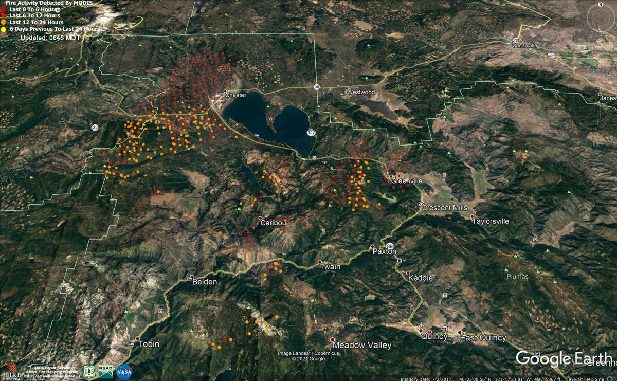
MODIS map of the Dixie Fire in Butte and Plumas Counties on Thursday at 5:45 A.M PST
Note: 1,200 Pixels Wide - Note: Older Yellow not shown
MODIS Active Fire Mapping Program Frequently Asked Questions
Update: Dixie Fire East Zone Afternoon Operations Update Video for Thursday, August 5, 2021
Update: Lassen County Sheriff's Office Announce New Road Closures for Dixie Fire
Update: Dixie Fire Afternoon Update Video for Thursday, August 5, 2021
Update: Butte County Sheriff Issues Dixie Fire Evacuation Warning
Update: Lassen County Sheriff's Office Announce Alternate Locations for Dixie Fire Evacuees to Stay
Update: Plumas National Forest Issues Stage III Fire Use Restrictions
Update: Per CAL FIRE; The Dixie Fire is now the 6th largest fire in CA history at 322,502 acres. As we head into the weekend, triple digit temps are expected in many parts of CA! Avoid the sparks that start wildfires by never using outdoor equipment or driving …
Update: Dixie Fire in Butte and Plumas Counties Narrative for Thursday, August 5, 2021 - Communities of Susanville and Chester Will Have Very Unhealthy Levels of Air Quality
Update: Dixie Fire West Zone Operations Morning Briefing Video For Thursday, August 5, 2021
Update: Dixie Fire East Zone Operations Morning Briefing Video for Thursday, August 5, 2021
Update: Smoke/Air Quality Outlook for the Dixie Fire in the Eastern Sierra for Thursday, August 5
August 5, 2021 - Dixie Fire in Butte County and Plumas County is 322,502 acres and 35% contained for Thursday morning.
Update 8:00 A.M. CAL FIRE
'Click' here to view full PDF
Basic Information
| Current as of | 8/5/2021, 6:31:12 AM |
| Incident Type | Wildfire |
| Cause | Under Investigation |
| Date of Origin | Tuesday July 13th, 2021 approx. 05:15 PM |
| Location | Feather River Canyon near Cresta Powerhouse |
| Incident Commander | CALFIRE Incident Management Team 1/California Interagency Incident Management Team 2 |
| Incident Description | Wildfire |
| Coordinates | 39.819 latitude, -121.419 longitude |
Current Situation
| Total Personnel | 4,785 |
| Size | 322,502 Acres |
| Percent of Perimeter Contained | 35% |
| Estimated Containment Date | Friday August 13th, 2021 approx. 12:00 AM |
| Fuels Involved |
Timber (Litter and Understory) Timber (Grass and Understory) Brush (2 feet) Fuel moistures are historically low, ERCs and BI are in the 97-99% |
| Significant Events |
Extreme Long-range Spotting Crowning Group Torching Extreme fire behavior through the night, fueled by low RH, Red Flag Warning, and very strong overnight winds. Fire grew 50 thousand acres in one night. |
Outlook
| Planned Actions |
Construct direct and indirect line to secure fire perimeter. Construct contingency lines in both zones. Provide structure defense in communities at risk: Chester, Hwy 36 corridor, Hwy 89 Corridor, Paxton, Greenville, Jonesville, Crescent Mills, Taylorsville, Prattville, Canyondam, Butte Meadows, Bucks Lake, Meadows Valley, Rush Creek and Greater Almanor area. Continue tactical patrol in the communities impacted by fire. |
| Projected Incident Activity |
12 hours: Fire continues to move towards controls lines burning unburned interior islands and ridges. Steep terrain, heavy fuel loading, and wind in alignment with canyons is making control difficult. On West Zone fire is actively burning in division L after spotting across the control line. Its currently threatening structures along the Hwy 36, 89 corridors, West Lake Almanor Area, and impacting surrounding areas. The mill in Chester is currently threatened. On the East Zone expected area to grow is divisions M, N, O, and P. Red flag warning in effect from 1Pm 8/4/2021 to 8Pm 8/5/2021. |
| Remarks |
California Interagency Incident Management Team 4 (CIIMT 4) is in command of the East Zone. State DPA: 11301 Federal DPA: 267198 |
Current Weather
| Weather Concerns |
EAST ZONE: CRITICAL FIRE WEATHER prevailed across the fire. Southwesterly wind gusted up to around 35 MPH while relative humidity dropped to the 7-12% range. A RED FLAG WARNING went into effect at 1:00 PM due to these expected critical fire weather conditions. Last night, the southwesterly winds were expected to diminish after sunset with gusts 10-15 MPH across the ridges and light and variable winds at lower elevations. However, humidity recovery will be poor. On Thursday, the winds will once again increase from the southwest with gusts up to 30 MPH. At the same time, relative humidity will once again drop into the teens and upper single digits. So, CRITICAL FIRE WEATHER conditions will continue through Thursday evening. Observed Weather Conditions: Mostly sunny with smoke. Wind Speed / Max. Gust Southwest 8-12 mph gusts 18-24 mph Temp 88 to 96. Direction Southwest RH 9-18% Forecasted Weather for Weds Operational Period Wind Speed / Max. Gust Sustained 15 mph gusts 30-40 mph Weds afternoon/evening. Temp 85-95 Direction Southwest RH 8-18% West Zone: Red Flag Warning continues through 9 pm Thursday. Gusty southwest winds challenged the fire. These conditions along with an unstable airmass will continue into Thursday morning. On Thursday the main dry cold front will pass over the region as winds turn to westerly Thursday afternoon. This will be the first westerly wind push the fire has felt in awhile. Temperatures will remain warm in the 80s with continued dry humidity values in the upper single digits and teens. By Thursday night winds will turn to a northeast direction bringing yet another wind shift to the fire though speeds should be light. Observed Weather Conditions: Smoke with plume dominated fire. Otherwise sunny. Wind Speed / Max. Gust Southwest 8-12 mph gusts 18-24 mph Temp 82 to 92 Direction Southwest RH 9-18% Forecasted Weather for Thursday Operational Period Wind Speed / Max. Gust Sustained 10-12 mph gusts 20-30 mph Thursday afternoon Temp 85-95 Directions: Southwest through midday then Westerly in the afternoon. RH 9-18% |
Click here for: Dixie Fire in Butte and Plumas Counties Wednesday, August 4, 2021 Updates