
Map for Monday, August 2, 2021
Note: 1,200 Pixels Wide
NOTE: Maps represent approximate information.
Evening Update: The Tamarack Fire as of Monday evening is still at 68,696 Acres with 82% Containment.
Basic Information
| Current as of | 8/2/2021, 5:37:45 PM |
| Incident Type | Wildfire |
| Cause | Lightning |
| Date of Origin | Sunday July 04th, 2021 approx. 04:00 PM |
| Location | 16 Miles south of Gardnerville, NV |
| Incident Commander | Dan Dallas, IC Bill Hahnenberg, Deputy IC |
| Incident Description | This Incident Continues To Be Managed With A Full Suppression Strategy, However Steep Inaccessible Terrain In Division Alpha Necessitates A Suppression Strategy Of Confinement. |
| Coordinates | 38.628 latitude, -119.857 longitude |
Current Situation
| Total Personnel | 344 |
| Size | 68,696 Acres |
| Percent of Perimeter Contained | 82% |
| Estimated Containment Date | Tuesday August 31st, 2021 approx. 12:00 AM |
| Fuels Involved |
Timber (Grass and Understory) Chaparral (6 feet) Timber (Litter and Understory) |
| Significant Events |
Moderate Backing Creeping Smoldering Fire is burning in mixed conifer, Pinyon Juniper and brush fuel types, with creeping and smoldering. |
Outlook
| Planned Actions |
Branch I - Keep fire south of China Spring and west of Highway 395. Keep fire south of Highway 88 and east of Blue Lake Road. Continue right sizing organization. Branch II - Keep fire north of Highway 89 (Monitor pass) and Hwy 4. Continue right sizing organization. Structure - Secure structures in all Branches. Continue right sizing organization. |
| Projected Incident Activity |
12 hours: Creeping fire with smoldering and limited potential spread. 24 hours: Creeping and smoldering fire with limited backing or flanking fire possible. |
| Remarks |
Acreage estimated from FireWatch flight on 7/29/2021 at 1322. Steep rugged terrain in Division Alpha necessitates a suppression strategy of confinement. Perimeter in Division Alpha represents 18% of the total fire perimeter. The remaining perimeter (82%) has been fully contained. |
Current Weather
| Weather Concerns |
Today's weather was partly cloudy. High Temp 76. Min RH 24%. Upslope winds 3-7 mph in the morning becoming SE 7 mph in the morning, increasing to SW to W 7-12 mph in the afternoon. HAINES 4, LAL 1 CWR 5%. Tonight-Partly cloudy becoming clear. Min Temp 46-49. Max humidity around 60-65%. West to NW winds 7-12 mph G22. Tuesday-Sunny. High Temps 77-79. Min RH 18-23%. Light upslope in the morning becoming SE to SW 8-13 mph G25. HAINES 5, LAL 1 CWR 0%. |
Update: Bear Cub Burned in Tamarack Fire Recovering from His Injuries
Update: Tamarack Fire Incident Commanders Discuss the Upcoming Transition of Command (Video)
Update: Liberty Update for Today, August 2: Markleeville Customers
We have some exciting news to share:
Repairs to the main electrical infrastructure into Markleeville damaged in the Tamarack Fire are complete. In the next couple hours, Liberty will be safely switching their power supply from the temporary generator to normal power source in the Markleeville area.
- Customers may experience a short, hour-long outage while Liberty is transferring from the temporary generator to normal source.
- If you are still out of power in this area after the switch in a couple hours, please check your fuse box or circuit breaker. After checking, if you still do not have power, please report the outage on the Report An Outage page at LibertyUtilities.com or call 1-844-245-6868.
Update: Tamarack Fire Operations Briefing Video for Monday, August 2, 2021
Update: Smoke/Air Quality Outlook for the Tamarack Fire in Alpine County for Monday, August 2
August 2, 2021 - The Tamarack Fire as of Monday morning is now at 68,696 Acres with 82% Containment.
Tamarack Fire Update
Monday, August 2, 2021 – 9:00 a.m.
Rocky Mountain Type 1 Incident Management Team
Dan Dallas, Incident Commander
Information Phone: 775-434-8629 (public and media)
Email: 2021.tamarack@firenet.gov
Information Staffing Hours: 8 a.m. to 8 p.m.
Special Notes: The Rocky Mountain Type 1 Incident Management Team will transition command of the fire to the Sierra Front Type 3 Team 1 tonight. Both teams thank the local communities for their hospitality and assistance.
Current Situation: Portions of the Humboldt-Toiyabe National Forest currently have Stage II fire restrictions. With dry, windy weather returning today, please do your part to prevent new fires from starting. Campfires are prohibited at this time and smoking is limited to vegetation-free areas. Vehicles can cause sparks; ensure nothing is dragging from your car, truck, or trailer and park away from dry vegetation. Please use caution with target shooting.
The fire is 82% contained. The rest of the uncontained fire edge is in Division A and is confined by natural barriers and limited fuels. Crews continue to patrol and mop up containment lines. Mop up is extinguishing residual fire near the perimeter to make sure it doesn’t spread outside of established containment line. Yesterday, infrared mapping guided firefighters to potential hotspots near Burnside Lake and the Hawkins Peak communication site.
The suppression repair group continues to work on priority areas based on information from local resource advisors. A Burned Area Emergency Response (BAER) team is starting on-the-ground assessment, validating information from satellites. This interagency team starts by looking for opportunities to protect soils and watersheds. Additional specialists will join them to support assessment of recreation, vegetation, archaeological, and geological resources.
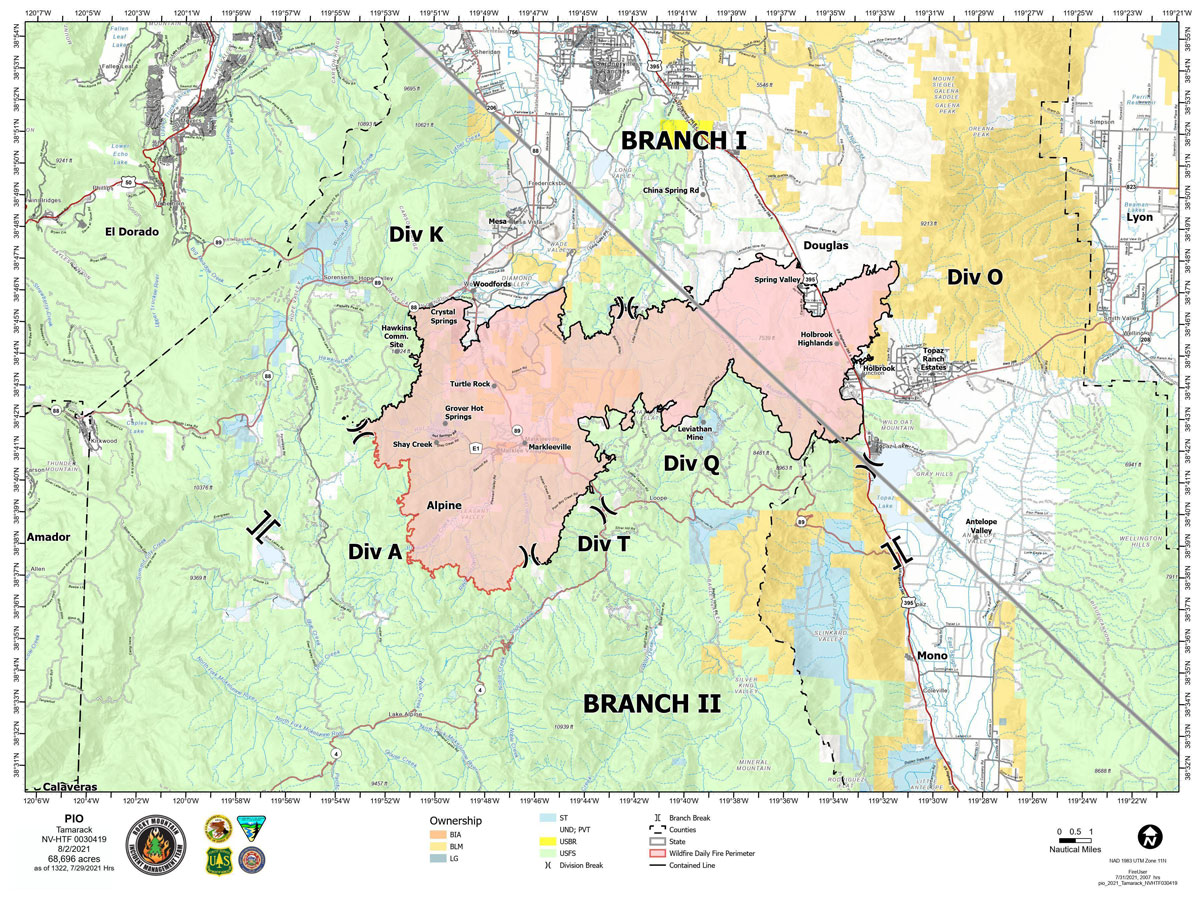
Branch I: Divisions K and O – The north and east edges of the fire are contained and in patrol status.
Branch II: Division Q and T – With containment complete in these divisions, crews will patrol today.
Division A – One wildland fire module remains in this steep, rocky terrain. Because protecting human life is the single overriding priority, a confinement strategy will be used in this area. Accessible areas are staffed with a wildland fire module. UAS and infrared mapping, and time-lapse cameras assist with observation 24 hours a day. In the unlikely event the fire crosses established Management Action Points, firefighters will use appropriate suppression tactics where feasible, with aircraft support.
Weather and Fuel Conditions: Today is forecast to be much drier and windier than the past week. The predicted high is 80 degrees, with a small chance storms could bring gusty outflow winds up to 40 mph. Tomorrow and Wednesday will trend toward warmer and drier weather, with high temperatures into the 90s.
Closures, and Fire Restrictions: For closures and fire restrictions on National Forest lands visit https://www.fs.usda.gov/alerts/htnf/alerts-notices. Grover Hot Springs State Park and Indian Creek Reservoir Campground remain closed to the public.
Click here for: Tamarack Fire in Alpine County Updates for Sunday, August 1, 2021