


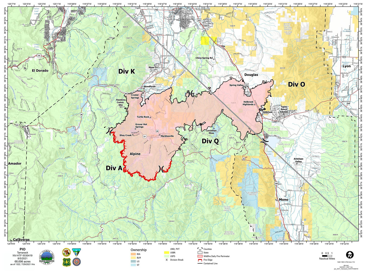
Map for Thursday, August 5, 2021
Note: 1,200 Pixels Wide
NOTE: Maps represent approximate information.
Evening Update: The Tamarack Fire as of Thursday evening is still at 68,696 Acres with 78% Containment.
Basic Information
| Current as of | 8/5/2021, 7:09:37 PM |
| Incident Type | Wildfire |
| Cause | Lightning |
| Date of Origin | Sunday July 04th, 2021 approx. 04:00 PM |
| Location | 16 Miles south of Gardnerville, NV |
| Incident Commander | Scott Stephenson, IC Tom Raw, Deputy IC |
| Incident Description | This Incident Continues To Be Managed With A Full Suppression Strategy, However Steep Inaccessible Terrain In Division Alpha Necessitates A Suppression Strategy Of Confinement. |
| Coordinates | 38.628 latitude, -119.857 longitude |
Current Situation
| Total Personnel | 422 |
| Size | 68,696 Acres |
| Percent of Perimeter Contained | 78% |
| Estimated Containment Date | Tuesday August 31st, 2021 approx. 12:00 AM |
| Fuels Involved |
Timber (Grass and Understory) Chaparral (6 feet) Timber (Litter and Understory) |
| Significant Events |
Moderate Single Tree Torching Backing Creeping Fire is in mixed conifer, pinyon-juniper, and brush fuel types with creeping, smoldering and single tree torching. |
Outlook
| Planned Actions |
Divs K & O - Keep fire south of China Spring and west of Highway 395. Keep fire south of Highway 88 and east of Blue Lake Road. Continue right sizing organization. Divs A & Q - Keep fire north of Highway 89 (Monitor pass) and Hwy 4. Continue right sizing organization. Structure - Secure structures in all Divisions. Continue right sizing organization. Hazard tree mitigation in Markleeville and Pleasant Valley areas. |
| Projected Incident Activity |
12 hours: Red Flag Warning until 2200 Thursday night. Dry conditions with increasing wind and instability. Backing and flanking fire with uphill runs possible when in alignment with gusty winds. Widespread critical conditions possible Thursday afternoon. Winds will be slow to drop off Thursday night with another round of poor humidity. 24 hours: Creeping fire with smoldering and limited to moderate potential for spread. Single tree torching. Drying trend with light winds. |
| Remarks |
Acreage estimated from FireWatch flight on 7/29/2021 at 1322. Steep rugged terrain in Division Alpha necessitates a suppression strategy of confinement. Perimeter in Division Alpha represents 18% of the total fire perimeter. The remaining perimeter (82%) has been contained to 78%. 4% of the fire remains uncontained. |
Current Weather
| Weather Concerns |
Red Flag Warning today. Today's weather was sunny. Temp's 75-83. Min RH 7-10%. Winds 3-12 mph with gusts to 20 mph becoming SW 12-17 mph in the afternoon, G3 mph, local. HAINES 5-6, LAL 1, CWR 0%. Tonight-Clear. Min Temp 45-50. Max humidity 30%. SW winds 13-18 mph, gusts 30 mph decreasing to 7-12 mph. Poor overnight RH recoveries. Haines 4-5. Friday-Sunny. Temps 75-80. Min RH 12-15%. Upslope winds 3-7 mph becoming N-NW 5-10 mph. HAINES 4-5, LAL 1 CWR 0%. |
Update: Escaped Bear Cub Burned in the Tamarack Fire Has Been Spotted
Update: Tamarack Fire Operations Briefing Video for Thursday Morning, August 5, 2021
August 5, 2021 - The Tamarack Fire as of Thursday morning is now at 68,696 Acres with 82% Containment.Tamarack Fire Update
Thursday, August 5, 2021 – 9:00 a.m.
Sierra Front Type 3 Incident Management Team 1
Scott Stephenson, Incident Commander
Information Phone: 775-434-8629 (public and media)
Email: 2021.tamarack@firenet.gov
Information Staffing Hours: 8 a.m. to 8 p.m.
Special Notes: Sierra Front Team 1 presented a Community Update on the Tamarack Fire last night. It can be seen on Facebook at www.facebook.com/tamarackfireinfo or on You Tube at https://bit.ly/TamarackVideo.
Winds are bringing in smoke from other fires in the region. People may notice more smoke in the air today.
Current Situation: A red flag fire weather warning and fuel and fire behavior advisory are in effect today. Extremely dry and windy conditions continue over the fire area. Fuels like sagebrush, logs, and pinyon/juniper are extremely dry and fire activity has increased within the perimeter. Firefighters are making maximum use of aerial resources for reconnaissance and dropping buckets of water on hotspots. An additional helicopter is assisting with the effort today.
Total containment has been reduced from 82% to 78%. This change is due to more accurate mapping. The fire has not breached the line in any area and the goal remains full suppression.
The suppression repair group continues to work on priority areas to minimize impacts of fire suppression activities on natural and cultural resources. They are also removing hazard trees for firefighter and public safety. The BAER team continues to assess public lands to identify imminent post-wildfire threats to human life and safety, property, and critical natural or cultural resources. When their assessment and recommendations are approved, agencies can take emergency stabilization measures before the first post-fire damaging events, like heavy rain or snow. Fires cause loss of vegetation and expose soils to erosion. This can increase potential for flooding, sediment, and debris flows.
Divisions K and O – The north and east edges of the fire are contained and in patrol status. Two hand crews, with support from helicopters, are focusing on the western edge of Division K, working to mop up and strengthen containment line. In Division O, two engines and crews are putting out hotspots near Spring Valley and Holbrook.
Division Q – This area has the most heat and is receiving the most wind at this time. There are a number of spots actively burning near the fire edge. Three hand crews and two engines are strengthening existing containment line and working to contain the remaining fire edge in the southwest portion of Division Q.
Division A – One wildland fire module remains in this steep, rocky terrain. A second module is on the way. Because protecting human life is the single overriding priority, firefighters are using a suppression strategy of confinement in this area. Helicopter reconnaissance flights, UAS, infrared mapping, and time-lapse cameras assist with observation 24 hours a day. In the unlikely event the fire crosses established Management Action Points, firefighters will use suppression tactics where feasible, with aircraft support.
Weather and Fuel Conditions: Dry, windy conditions continue today. The predicted high is 75 degrees, with relative humidity as low as 11%. Winds are out of the southwest, with expected gusts up to 35 mph.
Closures, and Fire Restrictions: For closures and fire restrictions on National Forest lands visit https://www.fs.usda.gov/alerts/htnf/alerts-notices.
Click here for: Tamarack Fire in Alpine County Updates for Wednesday, August 4, 2021
