


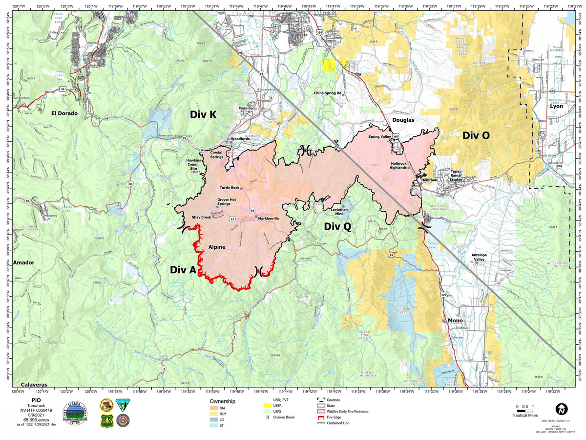
Map for Monday, August 9, 2021
Note: 1,200 Pixels Wide
NOTE: Maps represent approximate information.
Evening Update: The Tamarack Fire as of Monday evening has been reduced to 68,663 Acres with 80% Containment.
Basic Information
| Current as of | 8/9/2021, 5:28:43 PM |
| Incident Type | Wildfire |
| Cause | Lightning |
| Date of Origin | Sunday July 04th, 2021 approx. 04:00 PM |
| Location | 16 Miles south of Gardnerville, NV |
| Incident Commander | Scott Stephenson, IC Tom Raw, Deputy IC |
| Incident Description | This Incident Continues To Be Managed With A Full Suppression Strategy, However Steep Inaccessible Terrain In Division Alpha Necessitates A Suppression Strategy Of Confinement. |
| Coordinates | 38.628 latitude, -119.857 longitude |
Current Situation
| Total Personnel | 403 |
| Size | 68,663 Acres |
| Percent of Perimeter Contained | 80% |
| Estimated Containment Date | Tuesday August 31st, 2021 approx. 12:00 AM |
| Fuels Involved |
Timber (Grass and Understory) Chaparral (6 feet) Timber (Litter and Understory) |
| Significant Events |
Moderate Creeping Smoldering Single Tree Torching |
Outlook
| Planned Actions |
Divs K & O - Keep fire south of China Spring and west of Highway 395. Keep fire south of Highway 88 and east of Blue Lake Road. Continue right sizing organization. Divs A & Q - Keep fire north of Highway 89 (Monitor pass) and Hwy 4. Continue right sizing organization. Hazard tree mitigation in Markleeville and Pleasant Valley areas. |
| Projected Incident Activity |
12 hours: Sunny, haze and smoke. Light and variable winds overnight. Minimal fire behavior. 24 hours: Slightly warmer. Light winds 5-10 mph. Minimal fire behavior will provide more opportunity for crews to work on heat sources located by IR flight. Creeping and smoldering fire behavior. |
| Remarks |
Acreage estimated from FireWatch flight on 7/29/2021 at 1322. Steep rugged terrain in Division Alpha necessitates a suppression strategy of confinement. Perimeter in Division Alpha represents 18% of the total fire perimeter. The remaining perimeter (82%) has been contained to 80%. 2% of the fire remains uncontained. |
Current Weather
| Weather Concerns |
Less winds are projected for Monday and Tuesday as high pressure builds over the Great Basin. Haze with periods of thicker smoke from the Dixie Fire remain likely. Dry conditions with limited mid-slope humidity recoveries are anticipated early this week, before increasing moisture starting Wednesday brings daily chances for rain and thunderstorms through the upcoming weekend. Flash flood and debris flow hazards are possible on the burn scar. Today's max temp's valleys 86-91, mid-slopes 80-85. RH 13-18%. Winds valleys and mid-slopes 3-7 mph in the morning became N-NW 6-9 mph in afternoon. HAINES 4, LAL 1, CWR 0%. Tonight-clear and haze. Min Temp 55-60 in valleys, 60-65 mid slopes. Max humidity 43-53% valleys, 33-38% mid-slopes. NW winds in valleys and mid-slopes 7-10 mph in evening becoming light and variable downslope 2-4 mph. Haines 4. Fire behavior will be diminished today into Tuesday. |
August 9, 2021 - The Tamarack Fire as of Monday morning is now at 68,696 Acres with 80% Containment.
Tamarack Fire Update
Monday, August 9, 2021
Sierra Front Type 3 Incident Management Team 1
Scott Stephenson, Incident Commander
Information Phone: 775-434-8629 (public and media)
Email: 2021.tamarack@firenet.gov
Information Staffing Hours: 8 a.m. to 8 p.m.
Current Situation: Total containment is 80%. The strategy for this fire continues to be full suppression using a combination of containment in Divisions K, O, and Q, and confinement in Division A, keeping the fire in its current footprint. With the clearer skies, helicopters can once again work in conjunction with ground forces and drop buckets of water on hot spots.
Two suppression repair groups are working on priority areas to minimize impacts of fire suppression activities on natural and cultural resources. Crews are repairing dozer and hand lines to prevent soil erosion and water channeling. They are also removing hazard trees. Hazard trees are those that are fire-damaged and likely to fall on a road or developed site, posing a threat to firefighters and the public.
Divisions K and O – Division K is now in patrol status. An engine is supporting the repair crew and watching for any hot spots, especially near communities. In Division O, engines and crews are mopping up along the fire line and ensuring containment near homes and structures.
Division Q – This area currently has the most heat. Three hand crews working to strengthen existing containment line and contain the remaining fire edge in the southwest portion of the division.
Division A – A second module of self-sufficient wildland firefighters is being added to this division. Because of the extremely steep, jagged terrain and the lack of fire movement, firefighters are using a suppression strategy of confinement in this area. Firefighters on the ground, supported by aircraft, are taking action to prevent the fire from moving out of its current footprint. Helicopter reconnaissance flights, infrared mapping, and time-lapse cameras assist with observation 24 hours a day.
Weather and Fuel Conditions: Widespread smoke and haze continue today. The predicted high is 90 degrees, with relative humidity as low as 14%. Light, westerly winds are predicted. Fuels remain very dry.
Closures, and Fire Restrictions: For closures and fire restrictions on National Forest lands, visit: https://www.fs.usda.gov/alerts/htnf/alerts-notices.
Tamarack Fire Statistics:
Size: 68,696 acres
Containment: 80%
Total Personnel: 322
Location: Markleeville, CA
Reported: July 4, 2021
Cause: Lightning
For More Information:
Public and media information phone: 775-434-8629
Public and media email: 2021.tamarack@firenet.gov
InciWeb: https://inciweb.nwcg.gov/incident/7674/
Facebook: www.facebook.com/tamarackfireinfo
Twitter: https://twitter.com/tamarack_fire
YouTube: https://bit.ly/TamarackVideo
Air Now: https://fire.airnow.gov/#
Click here for: Tamarack Fire in Alpine County Updates for Sunday, August 8, 2021
