


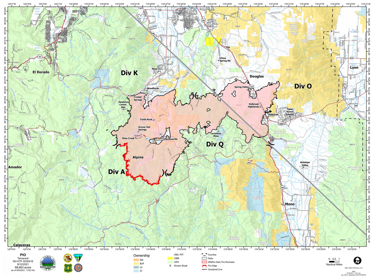
Map for Thursday, August 12, 2021
Note: 1,200 Pixels Wide
NOTE: Maps represent approximate information.
Evening Update: The Tamarack Fire as of Friday evening is now at 68,637 Acres with 82% Containment.
Basic Information
| Current as of | 8/13/2021, 7:55:12 PM |
| Incident Type | Wildfire |
| Cause | Lightning |
| Date of Origin | Sunday July 04th, 2021 approx. 04:00 PM |
| Location | 16 Miles south of Gardnerville, NV |
| Incident Commander | Scott Stephenson, IC Tom Raw, Deputy IC |
| Incident Description | This Incident Continues To Be Managed With A Full Suppression Strategy, However Steep Inaccessible Terrain In Division Alpha Necessitates A Suppression Strategy Of Confinement. |
| Coordinates | 38.628 latitude, -119.857 longitude |
Current Situation
| Total Personnel | 393 |
| Size | 68,637 Acres |
| Percent of Perimeter Contained | 82% |
| Estimated Containment Date | Tuesday August 31st, 2021 approx. 12:00 AM |
| Fuels Involved |
Timber (Grass and Understory) Chaparral (6 feet) Timber (Litter and Understory) |
| Significant Events |
Minimal Creeping Smoldering |
Outlook
| Planned Actions |
Divs K & O - Keep fire south of China Spring and west of Highway 395. Keep fire south of Highway 88 and east of Blue Lake Road. Continue right sizing organization. Div K & O in patrol status. Divs A & Q - Keep fire north of Highway 89 (Monitor pass) and Hwy 4. Continue right sizing organization. Hazard tree mitigation in Markleeville and Pleasant Valley areas. Completing suppression repairs in Div O and Q. |
| Projected Incident Activity |
12 hours: Minimal fire behavior. Localized moderate behavior on mid-slopes where recoveries are poor and that receive gusty and erratic winds from thunderstorms, especially in southern part of fire area near Div A. 24 hours: Minimal fire behavior. Isolated afternoon showers thunderstorms continuing until 2300. Winds shifting from NE in early afternoon to NW in late afternoon. Smoke and haze during the day and after 2300. |
| Remarks |
Acreage in box 7 decreased due to more accurate mapping. Steep rugged terrain in Division Alpha necessitates a suppression strategy of confinement. Perimeter in Division Alpha represents 18% of the total fire perimeter. The remaining perimeter (82%) has been contained. |
Current Weather
| Weather Concerns |
Isolated thunderstorm chances continue into the weekend. Some storms could produce heavy rain and gusty/erratic outflow winds. Unstable and hot conditions will continue to favor plume dominated fire growth this week. Mid-slope recoveries will remain poor to moderate. Observed: Haze and smoke in the morning. Cumulus clouds built over the fire area by 1300 with isolated showers and thunderstorms. Temps 90-93. Minimum RH 14-18%. Upslope winds 3-7 mph becoming N 5-10 mph early in afternoon, then shifting W in late afternoon. Gusty and erratic winds expected near thunderstorms in the afternoon. LAL 1 increasing to 2 after 1300. CWR 0% to 10% in the afternoon. Haines 5. Forecasted: Mostly cloudy tonight with isolated thunderstorms and showers in the evening. West winds 7-9 mph in the evening becoming downslope 2-5 mph. Gusty and erratic winds expected near thunderstorms. Similar weather into Saturday with Haines 4 to 5. |
Note: No Update was provided for Thursday.
Update: ***FLASH FLOOD WARNING*** Life-threatening flash flooding! For Grover Hot Springs, Markleeville, including CA Highway 89 within the Tamarack Burn Scar! Debris flow is possible moving through Hot Springs Creek and Sawmill Creek! Move away from recently burned areas immediately!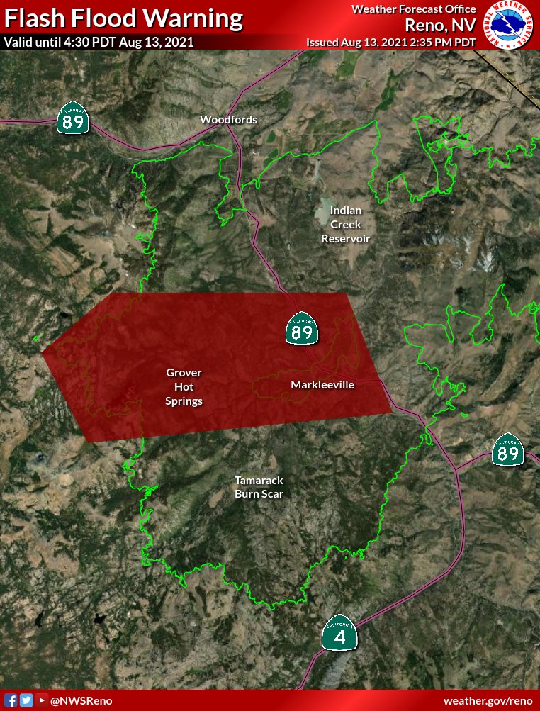
August 13, 2021 - The Tamarack Fire as of Friday morning is now at 68,637 Acres with 82% Containment.
Friday, August 13, 2021 – Sierra Front Type 3 Incident Management Team 1 Scott Stephenson, Incident Commander Information Phone: 775-434-8629 (public and media) Email: 2021.tamarack@firenet.gov
Information Staffing Hours: 8 a.m. to 8 p.m.
Current Situation: Total containment is 82%. The strategy for this fire continues to be full suppression using a combination of containment in Divisions K, O and Q and confinement in Division A. Helicopters will continue to support firefighters with buckets of water on hot spots as weather and smoke conditions permit. Two suppression repair groups, east and west, are working on priority areas to minimize impacts of fire suppression activities on natural and cultural resources. East repair group is repairing dozer and hand lines to prevent soil erosion and water channeling, and repairing fence lines that were damaged during suppression operations. The West repair group is removing hazard trees from the Pleasant Valley Road and Thornburg Canyon and along the Hot Springs Road. Hazard trees are fire-damaged and likely to fall on a road or developed site, threatening firefighter and public safety.
Today, the West repair group will begin removing hazard trees along Hot Springs Road. Crews will be working between 7:00am. and 8:00pm. In order to provide for public and firefighter safety, traffic will be controlled along the road, and motorists can expect possible delays of up to 30 minutes while crews remove trees from the roadway. The project is expected to be completed no later than Sunday, August 15. Residents in the Markleeville area can expect to see increased vehicle and truck traffic starting today and through the weekend
Divisions K and O – Divisions K and O have been combined and are now in a patrol status. Three engines will be supporting the suppression repair crews and watching for hot spots, especially near communities. Engines will also continue mopping up as needed along the fire perimeter ensure containment near homes and structures. Division Q – Two hand crews are working to strengthen the existing containment line and continue to mop up. . Division A –Two self-sufficient wildland fire modules and an additional hand crew are assigned to Division A. Because of the extremely steep, rugged terrain and the lack of fire movement, firefighters are using a suppression strategy of confinement in this area. Firefighters on the ground, supported by aircraft, are ready to act in the unlikely event the fire crosses established Management Action Points in the surrounding rocky terrain. Helicopter reconnaissance flights, infrared mapping, and time-lapse cameras assist with observation 24 hours a day.
Weather and Fuel Conditions: Smoke and haze will continue today, with light and variable winds in the morning. 15% chance of thunderstorms in the afternoon. The predicted high is 93 degrees, with relative humidity as low as 15%. Fuels remain very dry.
Closures, and Fire Restrictions: For closures and fire restrictions on National Forest lands, visit: https://www.fs.usda.gov/alerts/htnf/alerts-notices.
Tamarack Fire Statistics: Size: 68,637 acres Containment: 82% Total Personnel: 393 Location: Markleeville, CA Reported: July 4, 2021 Cause: Lightning For More Information: Public and media information phone: 775-434-8629 Public and media email: 2021.tamarack@firenet.gov InciWeb: https://inciweb.nwcg.gov/incident/7674/ Facebook: www.facebook.com/tamarackfireinfo Twitter: https://twitter.com/tamarack_fire YouTube: https://bit.ly/TamarackVideo Air Now: https://fire.airnow.gov/#
Click here for: Tamarack Fire in Alpine County Updates for Wednesday, August 11, 2021
