


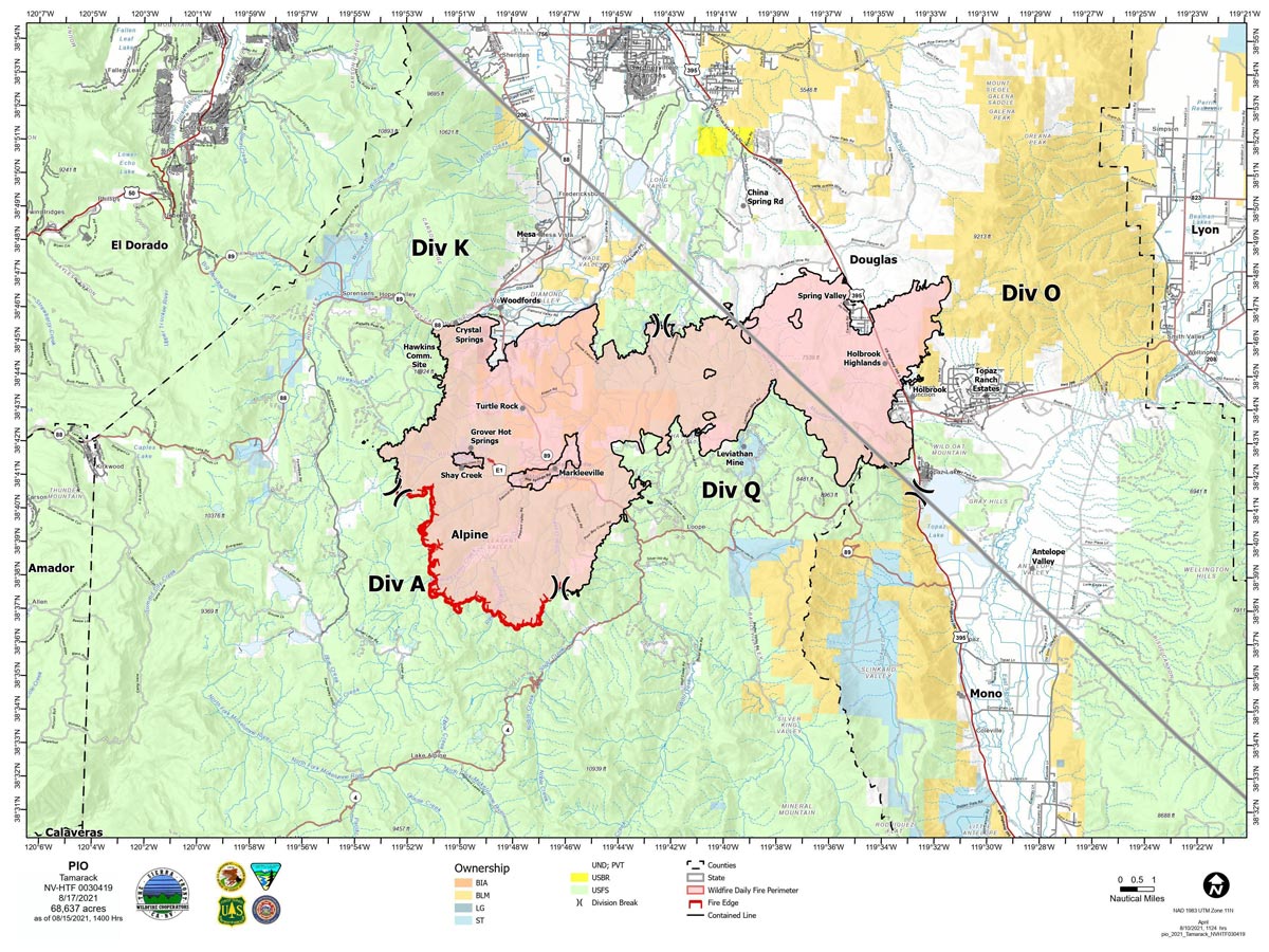
Map for Tuesday, August 17, 2021
Note: 1,200 Pixels Wide
NOTE: Maps represent approximate information.
Evening Update: Minimal fire behavior. Sunny conditions, gusty winds and low humidities could increase fire behavior. Tamarack Fire as of Wednesday evening is still at 68,637 Acres with 82% Containment.
Basic Information
| Current as of | 8/18/2021, 5:57:16 PM |
| Incident Type | Wildfire |
| Cause | Lightning |
| Date of Origin | Sunday July 04th, 2021 approx. 04:00 PM |
| Location | 16 Miles south of Gardnerville, NV |
| Incident Commander | Scott Stephenson, IC Tom Raw, Deputy IC |
| Incident Description | This Incident Continues To Be Managed With A Full Suppression Strategy, However Steep Inaccessible Terrain In Division Alpha Necessitates A Suppression Strategy Of Confinement. |
| Coordinates | 38.628 latitude, -119.857 longitude |
Current Situation
| Total Personnel | 265 |
| Size | 68,637 Acres |
| Percent of Perimeter Contained | 82% |
| Estimated Containment Date | Tuesday August 31st, 2021 approx. 12:00 AM |
| Fuels Involved |
Timber (Grass and Understory) Chaparral (6 feet) Timber (Litter and Understory) |
| Significant Events |
Minimal Creeping Smoldering |
Outlook
| Planned Actions |
Divs K & O - Keep fire south of China Spring and west of Highway 395. Keep fire south of Highway 88 and east of Blue Lake Road. Continue right sizing organization. Div K, O and Q in patrol status. Divs A- Keep fire north of Highway 89 (Monitor pass) and Hwy 4. Continue right sizing organization. Hazard tree mitigation in Markleeville and Pleasant Valley areas. |
| Projected Incident Activity |
12 hours: Minimal fire behavior. Gusty northerly winds could increase fire behavior in Div A. 24 hours: Minimal fire behavior. Sunny conditions, gusty winds and low humidities could increase fire behavior. |
| Remarks |
Acreage in Box 7 decreased due to more accurate mapping. Steep rugged terrain in Division Alpha necessitates a suppression strategy of confinement. Perimeter in Division Alpha represents 18% of the total fire perimeter. The remaining perimeter (82%) has been contained. Tamarack fire is assisting with resources on two small fires close to the Tamarack Fire. |
Current Weather
| Weather Concerns |
Red Flag Warning issued for areas west of the fire area but the Tamarack Fire did experience strong gusty winds and dry conditions. Critical fire conditions are possible. Observed: Cooler. Sunny in the morning then widespread smoke and haze by afternoon. Temperatures ranged from 67-81 over the fire area. Minimum RH 15-20%. Winds north to NE 8-15 mph with gusts up to 25 mph in the east part of the fire area. Haines 3. Forecasted: Widespread smoke and haze then clearing. Temps 41-47. Maximum RH 32-37 mid slopes, 45-50% valleys. Northeast to E winds 5-13 mph with gusts to around 25 mph north of Markleeville. Thursday: Sunny. Temps 67-83. RH 18%. Winds variable, NE to S 5-10 mph, gusts 20-25 mph. LAL 1. Haines 3. |
August 18, 2021 - Tamarack Fire Update for Wednesday, August 18, 2021. Size: 68,637 acres Containment: 82%
Wednesday, August 18, 2021 – 9:00 a.m. Sierra Front Type 3 Incident Management Team 1 Scott Stephenson, Incident Commander Information Phone: 775-434-8629 (public and media) Email: 2021.tamarack@firenet.gov Information Staffing Hours: 8 a.m. to 8 p.m.
Current Situation - Yesterday, the West suppression repair group continued with Hazard Tree Mitigation in the Pleasant Valley, Thornburg Canyon and Indian Creek Res. areas. Crews continue to make progress in DIV A as well as patrol DIV K, O and Q. The Tamarack Fire’s resources will continue assisting local jurisdictions with initial attack on any new fire starts.
West Repair Group - The West repair group will continue with Hazard Tree Mitigation in the Pleasant Valley and Thornburg Canyon area. Residents in the Markleeville area will continue to see increased vehicle and truck traffic throughout the week. Hazard Tree Mitigation in Indian Creek Res. area will continue today. Residents along Airport rd. are advised to watch for heavy equipment and truck traffic in the area.
Divisions K, O and Q – Divisions K, O and Q continue to be in patrol status. DIV Q has been supported by a spike camp just west of Monitor Pass that will be dismantled today. Two engines will continue to patrol these divisions and mop-up any hotspots they come across. Division A – Two hand crews and a Wildland Fire Module continue to mop-up in the Mokelumne Wilderness area. Because of the extremely rugged terrain and the lack of fire movement, firefighters are using a suppression strategy of confinement in this area. The crews are being supported by helicopters for both water drops and supplies. The Wildland Fire Module will remain in the wilderness area for the foreseeable future.
Weather and Fuel Conditions - Smoke and haze will continue today. The predicted high is 74-78 degrees, with relative humidity 15-20%. Fuels remain extremely dry. Closures, and Fire Restrictions - All public lands are closed within the fire’s perimeter, for more information visit: https://www.fs.usda.gov/alerts/htnf/alerts-notices. https://www.blm.gov/office/carson-city-district-office
Tamarack Fire Statistics: Size: 68,637 acres Containment: 82% Total Personnel: 283 Location: Markleeville, CA Reported: July 4, 2021 Cause: Lightning
For More Information: Public and media information phone: 775-434-8629 Public and media email: 2021.tamarack@firenet.gov InciWeb: https://inciweb.nwcg.gov/incident/7674/ Facebook: www.facebook.com/tamarackfireinfo Twitter: https://twitter.com/tamarack_fire YouTube: https://bit.ly/TamarackVideo Air Now: https://fire.airnow.gov/#
Click here for: Tamarack Fire in Alpine County Updates for Tuesday, August 17, 2021
