


Update: USDA Forest Service Issues Lake Tahoe Basin Management Unit Backcountry Closure Order
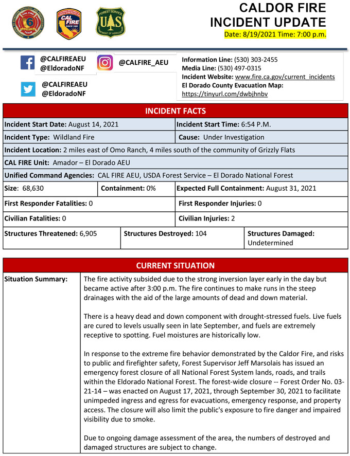
Evening Update Per CAL FIRE: California Caldor Fire is at 68,630 Acres, with 0% Containment, and 1,118 personnel assigned for Thursday evening.

MODIS map of the Caldor Fire on Thursday at 4:45 A.M PST
Note: 1,200 Pixels Wide - Note: Older Yellow not shown
MODIS Active Fire Mapping Program Frequently Asked Questions
August 19, 2021 - Caldor Fire Update for Thursday Morning, 65,474 acres with 0% containment.
Update CAL FIRE: California Caldor Fire is at 65,474 Acres, with 0% Containment for Thursday morning.
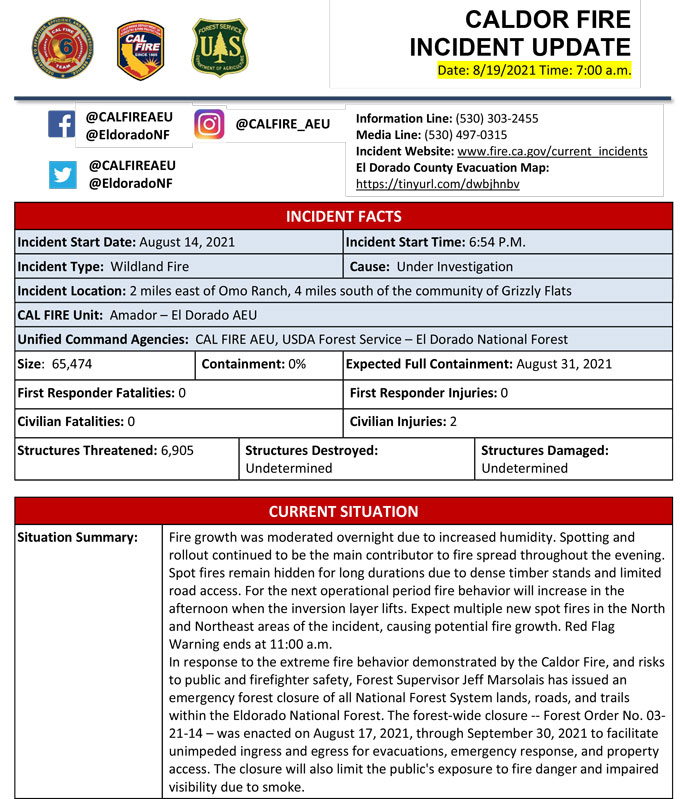
Basic Information
| Current as of | 8/19/2021, 6:57:16 AM |
| Incident Type | Wildfire |
| Cause | Under Investigation |
| Date of Origin | Saturday August 14th, 2021 approx. 07:00 PM |
| Location | 4 miles South of Grizzly Flats, 2 miles East of Omo Ranch |
| Incident Commander | CAL FIRE AEU, USDA Forest Service – Eldorado National Forest |
| Incident Description | Fire Growth Was Moderated Overnight Due To Increased Humidity. Spotting And Rollout Continued To Be The Main Contributor To Fire Spread Throughout The Evening. Spot Fires Remain Hidden For Long Durations Due To Dense Timber Stands And Limited Road Access. For The Next Operational Period Fire Behavior Will Increase In The Afternoon When The Inversion Layer Lifts. Expect Multiple New Spot Fires In The North And Northeast Areas Of The Incident, Causing Potential Fire Growth. Red Flag Warning Ends At 11:00 A.m. In Response To The Extreme Fire Behavior Demonstrated By The Caldor Fire, And Risks To Public And Firefighter Safety, Forest Supervisor Jeff Marsolais Has Issued An Emergency Forest Closure Of All National Forest System Lands, Roads, And Trails Within The Eldorado National Forest. The Forest-wide Closure -- Forest Order No. 03-21-14 – Was Enacted On August 17, 2021, Through September 30, 2021 To Facilitate Unimpeded Ingress And Egress For Evacuations, Emergency Response, And Property Access. The Closure Will Also Limit The Public's Exposure To Fire Danger And Impaired Visibility Due To Smoke. Please Register For Code Red Through The Local County Sheriff’s Office El Dorado County Code Red: Https://ready.edso.org/ Amador County Code Red: Https://www.amadorsheriff.org/administration-division/codered |
| Coordinates | 38.584 latitude, -120.534 longitude |
Current Situation
| Total Personnel | 653 |
| Size | 65,475 Acres |
| Estimated Containment Date | Tuesday August 31st, 2021 approx. 12:00 AM |
| Fuels Involved |
Heavy timber. Steep terrain. |
| Significant Events |
EL DORADO COUNTY MANDATORY EVACUATIONS ORDERS: - Grizzly Flat: The areas on Grizzly Flats Road east of Kendra Way into Grizzly Flats Proper. The areas of Diamond Railroad Grade, Old School House, Sweeney Road, Caldor Road, and steely Ridge. • Grizzly Flats Road east of four corners in Somerset into Grizzly Flats Proper. - The areas of Myers Lane, Varmet Ridge Road, Rodwell Canyon Road, Snowbird Lane, and Mehwald Lane. • East of Sly Park Road between Highway 50 and Mormon Emigrant Trail to Ice House Road. This includes the communities of Pacific House and Fresh Pond. • North of Highway 50 ,east of Forebay Road to Ice House Road. • Intersection of Perry Creek and Hawk Haven , the East side of Fairplay Road from Perry Creek South to Cedarville Road. This includes Slug Gulch, Omo Ranch, and all roads off of Slug Gulch and Omo Ranch. • All roads off of Omo Ranch from Cedarville Road to Hwy 88. • The area between Highway 88 and Mormon Emigrant Trail • South of Highway 50 from Snows Road to Ice House Road. • Between Highway 50 and Slab Creek from Snows Road to Ice House Road. - South of Highway 50 from Ice House Road to Silver Fork Road. This includes the community of Kyburz. • North of Highway 50 from Ice House Road to Silver Fork Road to include Ice House Reservoir, Union Valley Reservoir, and Loon Lake. EVACUATION WARNINGS: -North of Slab Creek to Wentworth Springs Road between Sand Mountain and Loon Lake. • Mosquito Road from the bridge North to include the Community of Swansboro. • North of Highway 50 to Slab Creek between Smith Flat and Snows Road. • South of Highway 50 to Pleasant Valley between Smith Flat and Snows Road, and North of Pleasant Valley between Holm and Newtown. • South of Pleasant Valley between Bucks Bar Road and Newtown Road, East of Bucks Bar Road to Mt Aukum Road. • Southwest of Bucks Bar Road to Ladies Valley Road including the community of Outingdale, Ant Hill Road, Perry Creek Road and Sand Ridge between Ladies Valley Road and Bucks Bar Road. • East of Mt Aukum Road (E16) from Bucks Bar Road to Omo Ranch Road. North of Omo Ranch Road to the intersection of Omo Ranch Road and Fairplay Road. • South of Omo Ranch to the El Dorado County Line between Mt Aukum Road (E16) and Fairplay Road to include Coyoteville Road, Cedar Creek and all tributary roads. - North of Slab Creek to Wentworth Springs Road between Sand Mountain and Loon Lake. • Mosquito Road from the bridge North to include the Community of Swansboro. • North of Highway 50 to Slab Creek between Smith Flat and Snows Road. AMADOR COUNTY - EVACUATION WARNINGS - Shenandoah Road at the Amador County line west through the River Pines community, continuing west on Shenandoah Road to Ostrom Road. South on Ostrom Road to Jibboom Street, West on Jibboom Street to Fiddletown Road. East on Fiddletown Road to Hale Road. South on Hale Road to Shake Ridge Road. East on Shake Ridge Road to Charleston Road. South on Charleston Road to the intersection of Charleston Road and Rams Horn Grade. Due east to Highway 88 at Tiger Creek Road. Tiger Creek Road east to Salt Springs Reservoir Road. East on Salt Springs Reservoir Road to the east end of the Salt Springs Reservoir. Due north from the east end of Salt Springs Reservoir to Highway 88. SHELTER INFORMATION: Shelter open with availability - El Dorado Community Center 6139 Pleasant Valley Road El Dorado, CA Shelter Full Cameron Park CSD 2502 Country Club Drive Cameron Park, CA Shelter Closed Diamond Springs Fire Hall 3734 China Garden Diamond Springs, CA LARGE ANIMAL SHELTER: - Amador County Fairgrounds, 18621 Sherwood Street, Plymouth, CA 95669 (Empire Street Gate) SMALL ANIMAL SHELTER: - Call (530) 621-5795 |
Outlook
| Projected Incident Activity |
Current Weather
| Weather Concerns |
Red Flag Warning in effect until 8 PM Wednesday. Warm and dry conditions expected with low daytime relative humidities. Locally gusty west to southwest winds forecast today over the burn area. Winds are expected to become less gusty but quickly shift from the east to northeast tonight around 2200. Winds are forecast to increase and shift again back from the west Wednesday morning. |
Click here for: California Caldor Fire Wednesday, August 18, 2021 Updates
