


Update: California Monument Fire Virtual Community Meeting Video for Saturday, August 28, 2021
Evening Update: Monument Fire Update for Saturday evening, the fire has increased to 161,133 Acres with 23% Containment and 2,370 total personnel.
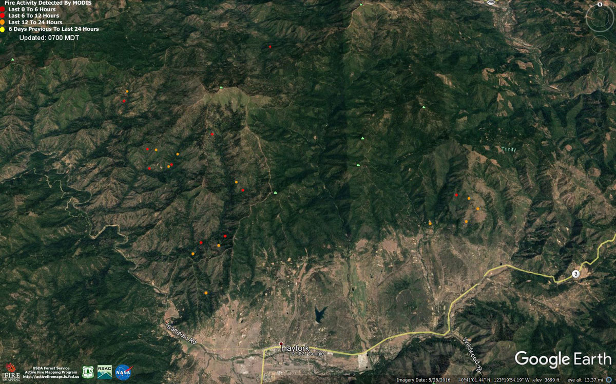
MODIS map of the Monument Fire on Saturday at 6:00 A.M PST
Note: 1,200 Pixels Wide - Note: Older Yellow not shown
MODIS Active Fire Mapping Program Frequently Asked Questions
Update: Monument Fire Virtual Public Meeting Set for 6:00 P.M. Tonight, August 28, 2021
Update: Monument Fire Operational Video Updates for Saturday Morning, August 28, 2021
August 28, 2021 - Monument Fire Update for Saturday Morning, 160,148 acres with 22% containment.
Basic Information
| Current as of | 8/28/2021, 6:50:28 AM |
| Incident Type | Wildfire |
| Cause | Lightning |
| Date of Origin | Friday July 30th, 2021 approx. 06:00 PM |
| Location | Del Loma, CA near Monument Peak |
| Incident Commander | Norm McDonald, Alaska IMT and Mike Parkes, CAL FIRE IMT |
| Incident Description | Wildfire |
| Coordinates | 40.752 latitude, -123.337 longitude |
Current Situation
| Total Personnel | 2,319 |
| Size | 160,148 Acres |
| Percent of Perimeter Contained | 22% |
| Estimated Containment Date | Monday November 01st, 2021 approx. 08:00 AM |
| Fuels Involved |
The fire remains squarely within the 2008 Buckhorn, Eagle, Miners and Cedar Fire footprints. Type converted brush and a heavy dead and down component dominate most areas. Fuels to the north of Hayfork are characterized as widely spaced mixed conifer and grass. All live fuels are cured to levels normally seen in late September. |
| Significant Events |
Fire is fuels driven resulting from extended and extreme/enhanced drought with influence of steep slopes and winds. Several small, short duration runs, exhibiting moderate fire behavior, occurred late in the burn period yesterday. Activity was associated with partial clearing of smoke and adequate ventilation to allow fire behavior to increase. Flanking and backing fires consumed all surface fuels with moderate flame lengths and rates of spread. Minimal surface wind allowed smoke to remain over the majority of the fire and created a cap which limited fire behavior. Moderate overnight RH recovery has been consistent for the past 3 nights. |
Outlook
| Planned Actions |
Provide structure defense for the communities of Burnt Ranch, Friedrich Road, Hawkins Bar, Trinity Village, Cedar Flat, Underwood Mountain, 9-Mile Bridge, and Bar 717. In the southwest segment of the fire, patrol and mop-up along Corral Bottom Road/47 Road and Prodigy site. Continue direct handline down Haypress Road. Continue developing and improving primary indirect line along Pattison Road to Pattison Ridge, Pattison Peak Road, down through Halfway Ridge and east to Jud Creek tying in at Nine Mile Bridge to connect with the South Zone. Monitor fire on north side of the Trinity River backing west off of Ironside Mountain. Fire is backing into the confluence of the New and Trinity Rivers at this point and if established to the west, resistance to control will be problematic. Patrol and secure current fire line around structures within the communities of Don Juan Point east through Big Flat along the Highway 299 corridor. Provide structure defense for the communities from Helena east through Junction City and north along Canyon Creek and the East Fork of the North Fork Trinity River. Scout for opportunities for indirect line north of the New River from Happy Camp Mountain to the confluence of the Trinity River. Take action on any spots across and west of the New River. Prepare structures along the New River from Five Waters northward towards Denny. Continue to prep structures in Canyon Creek. Evaluate options for managing fire to keep from progressing east of the East Fork of the North Fork and impacting values of risk to the east. This may include burning out along the East Fork and Hobo Gulch Road and implementing dozer line along Backbone Ridge within the Trinity Alps Wilderness. Continue mop-up and patrol activities to build depth and containment lines. Due to limited firefighting resources, crews will be surged to areas with more active fire behavior where they will continue constructing line and engaging in structure defense as needed. |
| Projected Incident Activity |
12 hours: Active fire growth will likely occur in areas where the smoke clears. All fuels remain critically dry and Energy Release Components have increased over the past few days as daytime clearing has allowed fuels to dry out more. High resistance to control is being observed on spot fires and slop-overs. Dry conditions will contribute to the potential for spotting and active surface fire. Moderate to high fire spread and flame lengths are anticipated in all areas where established fire has smoke clear out enough to allow solar heating and max predicted temperatures to be reached. Even under smoke covered conditions, the fire could see moderate growth in all areas of uncontained line. 24 hours: Potential for active fire behavior with high resistance to control is likely in areas where the smoke clears. Predicted winds likely will bring in smoke from the River Complex and reduce ventilation on the northern and eastern fringes of the fire. The possibility of clearing and ventilation is reduced from previous burn periods as a north to northeast flow will likely push smoke into drainages. Expect moderate fire behavior to develop in areas with established fire in areas that the smoke clears out by late afternoon, mainly on ridges. |
Current Weather
| Weather Concerns |
Observed Weather: A ridge of high pressure over the eastern Pacific strengthened westward which funneled a dry northerly flow across the region and blanketed much of the Monument fire under smoke through midday. Overnight humidity recovery was generally moderate to good and ranged from 45-70%. Low temperatures were in the 50s. Smoke from fires to the north lingered through early afternoon, but temperatures still warmed about 3-8 degrees above yesterday under the strengthening ridge with highs in the low 80s on ridges to low 90s in valleys. Smoke shifted eastward with partial clearing across Branch 1 in the late afternoon and early evening, with weaker up-canyon wind flow today compared to yesterday with west to northwest winds across ridges. Minimum humidity fell into the 13-25% range. Saturday Outlook: Hot and critically dry weather with transitioning winds will impact the fire Saturday under light offshore flow. Conditions will be more unstable but many areas of the fire will remain capped due to lingering smoke. Critically low humidity in the teens is expected with poor overnight recovery Saturday night. |
Click here for: California Monument Fire Friday, August 27, 2021 Updates
