Update to Evacuation Warnings - Effective Immediately for El Dorado County and Alpine County
Evacuation Order:
El Dorado County
Desolation Wilderness from the watershed ridge to the CA ENF/CA TMU wilderness boundary. From the El Dorado/Placer County line to Echo Lakes.
Alpine County
Highway 89 south, from Luther Pass Road to the Pickets Junction (Highway 88). West on Highway 88 to Kirkwood. South to include Kirkwood Ski Resort and Caples Lake.
Evacuation Warning:
El Dorado County
The remaining area of the Lake Tahoe Basin. From the Alpine/El Dorado County line, north along the California/Nevada state line to Lake Tahoe. North along the waters edge to the El Dorado/Placer County line. West along the El Dorado/Placer County line to McKinney Lake. Alpine County Highway 88 at Forestdale Road. West of Forestdale Road and south to the Pacific Crest Trail Crossing. West of the Pacific Crest Trail to the Summit City Canyon Trail. West of Summit City Canyon Trail and south to the El Dorado / Stanislaus National Forest Line. El Dorado / Stanislaus National Forest Line west to the Alpine and Amador County line.
South of Armstrong Summit to Woodfords to Forestdale Road, north of Highway 88 and Highway 89 to Armstrong Summit.
Evacuation Shelter:
Nevada
• A Red Cross Shelter is open for those evacuating from the area at the Douglas County Community Center, 1329 Waterloo Lane, Gardnerville, NV
NOTES: Please go to: www.tinyurl.com/EDSOEVAC for an online evacuation map. All previous evacuation orders and warnings remain in effect. A mandatory evacuation order is defined as an immediate threat to life. This is a lawful order to leave now. The area is lawfully closed to public access.
An evacuation warning is defined as a potential threat to life and/or property. Those who require additional time to evacuate and those with pets and livestock should leave now.
Update to Evacuation Orders, Warnings and Road Closures Effective Immediately for El Dorado County and Alpine County Road Closures:
- The Highway 50 closure has been extended East to Sawmill Road
- Highway 50 at Sawmill
- Pioneer Trail at Elks Club
- Elks Club at Highway 50
- Highway 89 at Highway 88 junction
- Fallen Leaf at Tahoe Mountain
Evacuation Routes:
El Dorado County
- Residents evacuating the area should use Highway 50 East or Highway 89 North.
Alpine County
- West on Highway 88 to Northbound 89 to Eastbound Highway 50
Evacuation Order:
El Dorado County
- Christmas Valley from Highway 89 West to Echo Summit
- Highway 89 due West to Watershed Ridge/Echo Summit and South to the Amador/El Dorado County line.
- The area from Luther Pass Road, north along the El Dorado/Alpine County line to Armstrong Pass. West from Armstrong Pass to Upper Apache at Meyers. West on Upper Apache to Highway 50. West on Highway 50 to Highway 89. South on Highway 89 to the El Dorado/Alpine County line. This includes all homes on both sides of Highway 89.
- The area from Upper Apache at Meyers, north along Highway 50, to Elks Club Drive. East on Elks Club Drive to Pioneer Trail, extending due south to Upper Apache at Meyers. (This includes all homes off of Oneidas, Mandan, Apache, Ottawa and Player).
- The area North on Highway 50 from Highway 89 to Saw Mill Road. West on Saw Mill Road to Angora Ridge, extending to the Echo Summit.
Alpine County
- Highway 89 South from Luther Pass Road to Pickets Junction (Highway 88)
- West on Highway 88 to Kirkwood
Evacuation Warning:
El Dorado County
- The area from Sawmill Road at Lake Tahoe Blvd. extending north to Pope Beach. Along the water’s edge to Eagle Point. From Eagle Point west, to Desolation Wilderness, across Emerald Bay.
Evacuation Shelter:
Nevada
- A Red Cross Shelter is open for those evacuating from the area at the Douglas County Community Center, 1329 Waterloo Lane, Gardnerville, NV.
NOTES: Please go to: www.tinyurl.com/EDSOEVAC for an online evacuation map.
All previous evacuation orders and warnings remain in effect
A mandatory evacuation order is defined as an immediate threat to life. This is a lawful order to leave now. The area is lawfully closed to public access.
An evacuation warning is defined as a potential threat to life and/or property. Those who require additional time to evacuate and those with pets and livestock should leave now.
Safety Message: The public is reminded to stay vigilant on current fire conditions. Please continue to adhere to road closures and any evacuation orders and warnings. A reminder to drive slowly and yield to emergency personnel in the area. There will be smoke in the respective areas as firefighters continue firefighting operations. If at any time you feel unsafe, please call 911.
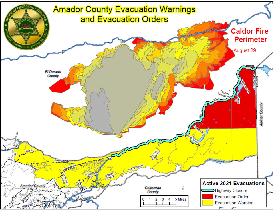
*** New Evacuation Orders ***
Updated Map as of 5:56 P.M.
CodeRED alert is going out and deputies are currently conducting door to door evacuations in the Silver Lake and Kirkwood areas (To include Kirkwood Lake). Hwy 88 is now closed at Dew Drop Road.
The new mandatory evacuation order area is as follows:
“South of Highway 88 along the Amador/El Dorado County line from Dufrene Road, due east to the Amador/Alpine County line and from the Amador/Alpine County line north to Hwy 88. Please refer to the red shaded area on the map below.”
Our animal shelter located at the Amador County Fairgrounds is still open for large and small animals. A Temporary Evacuation Point will be open at the Italian Picnic Grounds (581 Hwy 49) in Sutter Creek for Amador County residents.
Source: Amador County Sheriff's Office
Additional Information from Amador County Sheriff's Office:
CodeRED alert is going out and deputies are currently conducting door to door evacuations in the Silver Lake and Kirkwood areas (To include Kirkwood Lake). Hwy 88 is now closed at Dew Drop Road.
The new mandatory evacuation order area is as follows:
“South of Highway 88 along the Amador/El Dorado County line from Dufrene Road, due east to the Amador/Alpine County line and from the Amador/Alpine County line north to Hwy 88. Please refer to the red shaded area on the map below. “
Our animal shelter located at the Amador County Fairgrounds is still open for large and small animals. A Temporary Evacuation Point will be open at the Italian Picnic Grounds (581 Hwy 49) in Sutter Creek for Amador County residents.
** Evacuation Orders and Warnings **
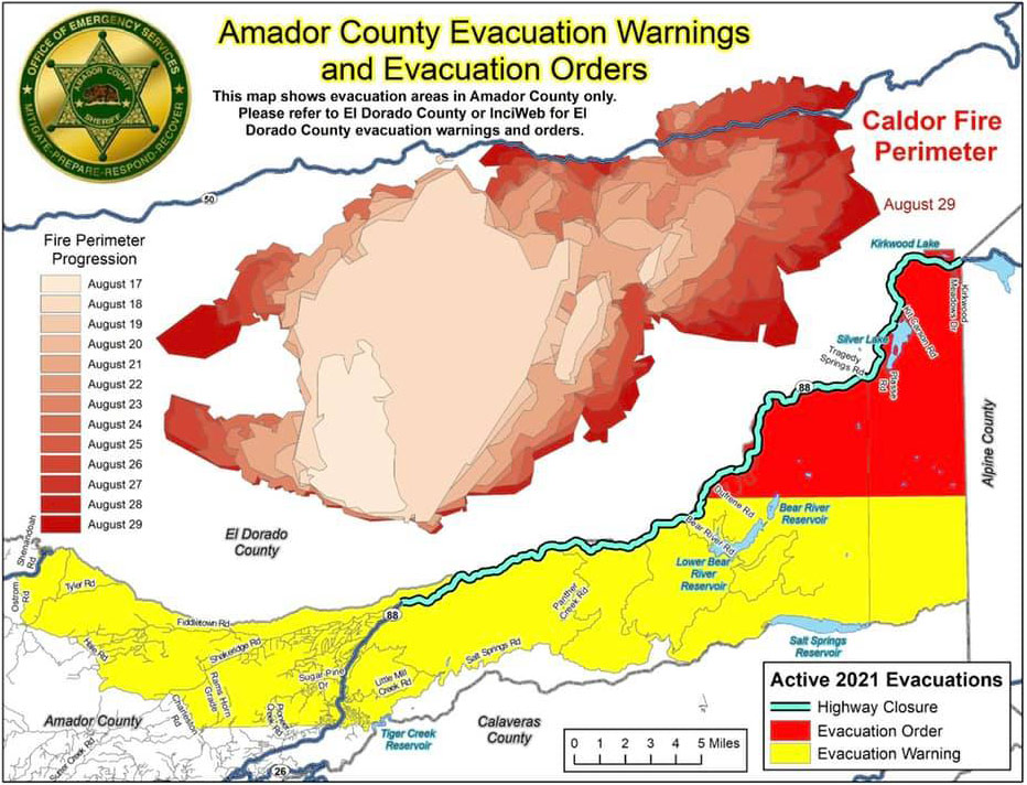
August 29, 2021 - Update to Evacuation Orders, Warnings, and Road Closures - Effective Immediately for Amador County.
Road Closures:
- Highway 88 is closed between Omo Ranch Rd. and the Highway 88/89 interchange.
Evacuation Order: Amador County
- South of Highway 88 along the Amador/El Dorado County line from Dufrene Road, due east to the Amador/Alpine County line and from the Amador/Alpine County line north to Hwy 88.
Shelter Info
- Our Red Cross TEP will be at the Italian Picnic Grounds in Sutter Creek. 581 Hwy 49.
NOTES: All previous evacuation orders and warnings remain in effect
A mandatory evacuation order is defined as an immediate threat to life. This is a lawful order to leave now. The area is lawfully closed to public access.
An evacuation warning is defined as a potential threat to life and/or property. Those who require additional time to evacuate, and those with pets and livestock should leave now.
Safety Message: The public is reminded to stay vigilant on current fire conditions. Please continue to adhere to road closures and any evacuation orders and warnings. A reminder to drive slowly and yield to emergency personnel in the area. There will be smoke in the respective areas as firefighters continue firefighting operations. If at any time you feel unsafe, please call 911.