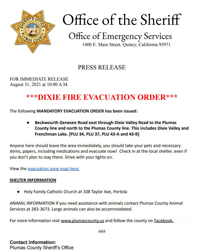
Click here for: California Dixie Fire Tuesday, August 31, 2021 Updates

PUBLIC NOTICE – DIXIE FIRE EVACUATION STATUS UPDATE for 8:30 P.M.
The emergency alert zone map can be accessed at: community.zonehaven.com
Mandatory Evacuation Orders remain in place for:
- North of Hwy 36 south of Hwy 44 from the Lassen County Line east to Devil’s Corral – Zones LAS-E027-A, E029-A, E028
- North of Hwy 44 from Forest Route 33NO2 east to County Rd A21 and north to Crater Lake Campground – Zones LAS-E035-F
- South of Hwy 36 south and east of Mtn Meadows Reservoir east to Coppervale – Zones LAS-E019, EO18, E026, E017-A
- Janesville and Milford east of the Plumas County Ln from Janesville Grade south to Milford Grade along the mountain side (unpopulated area) Zones LAS-E012-K, E010-B, C, F
Evacuation Warnings remain in place for:
- Milford and Herlong area east (lake side) of Hwy 395 from the Thunder Mountain Rd intersection south to County Rd A26/Garnier Rd. This includes the south side of County Rd A25 east to but NOT including Sierra Army Depot – Zones LAS-E011-A, E008-A, B, E002-B, C
- Antelope Mountain and Campbell Mountain area east of County Rd A21 and west of County Rd A1 – Zone LAS-E035-B and E035-I
- Janesville and Milford west of Hwy 395 from Janesville Grade south to Milford Grade and west to the base of the mountains (unpopulated area) Zones LAS-E012-F,J LAS-E010-G&H LAS-E010A, D, E and LAS-E009-B
- Milford west (mountain side) of Hwy 395 from Milford Grade south to the intersection of County Rd A26 Garnier Rd - Zones LAS-E009-A and E001-A
- South of Hwy 36 from Devil’s Corral east to Korver Rd and south to Gold Run Rd Zone LAS-E016-G
- Clear Creek, Westwood, and Pine Town area south of Hwy 36 from the Lassen County line east to the Willard Hill area – Zones LAS-E020, EO23, E027-B, E029-B
- Bizz Johnson Trail area south of Hwy 36 from Thumper Hill east to Miller Crossing and south to Bauer Rd – Zone LAS-016-B, D, E
- Willard Creek Rd south of Hwy 36 and Korver Rd from Hwy 36 south to the fork of Korver Rd – Zones LAS-E016-A and E017-C
- Area south of Hwy 44, north of Hwy 36, west to Hog Flat Reservoir – Zones LAS-E030-A & B
- Bogard area north of Hwy 44 from Pittville Rd east to County Rd A21 and north to Blacks Mountain, Harvey Mountain and south of Ashurst Lake – Zones LAS-E035-D,E,F,G
- West of County Rd A1 from the A21 intersection north to Forest Services Route 32NO2 – Zone LAS-E035-C
Source: Lassen County Sheriff's Office
The follow areas are being changed from a Mandatory Evacuation Order to an Evacuation Warning:
![]() ● Humbug Road from the intersection of the Humbug-Humboldt Road west to the Butte County line and everything south of the Humbug Road [PLU Zone 006]
● Humbug Road from the intersection of the Humbug-Humboldt Road west to the Butte County line and everything south of the Humbug Road [PLU Zone 006]
● Hwy 36 south to the west side of Hwy 89, including Mud Lake, Soldiers Meadows, and Shanghai Creek area, south to Humbug Road, and west to Butte County line [PLU Zone 006A]
● From the Hwy 89/Hwy 36 Junction, north along Stover Mountain Road to the County Line, and west from the Hwy 89/Hwy 36 Junction along the south side of the highway to the county line. [PLU Zone 007]
● Chester Juniper Lake Road north, Hwy 312 northwest, Forest Road 28N61 north west. [PLU Zone 008A]
UPDATED Evacuation Zone MAP: community.zonehaven.com.
*Residents should evaluate their own circumstances when determining if they will return home.
WATER: Please consult your water district authority for information on drinking water quality.
Essential services: Will likely be delayed in starting back up again. There remains potential risk of intermittent power outages for the remainder of this fire.
When residents do return to burned areas, it is important to follow protocols for re-entry provided by Plumas County Environmental Health. Only those with residence in the area should enter at this time. For more information visit plumascounty.us/2868/Dixie-Fire-Information
While we understand evacuated residents are understandably eager to get back to their homes and properties, the Dixie Fire is still active, and the public must remain out of Mandatory Evacuation Order zones until the orders are downgraded to warnings or lifted. There are also several health and safety hazards in affected areas that must be mitigated prior to reentry. Please do not attempt to enter restricted areas until evacuation orders are lifted. You can determine your zone and see evacuation status by entering your address on the evacuation map located at: community.zonehaven.com.
In the burn area, you will encounter dangerous conditions and will be exposed to toxic materials that may include but are not limited to: Embers /hot ash, Hazardous materials, including: ash, asbestos, heavy metals, oils, fire retardants, pesticides and other hazardous materials, Puncture hazards, including: broken pipes, exposed nails, broken glass, damaged structural elements, Potential explosive hazards including: propane tanks, ammunition, and solvents, Slippery surfaces, Toxic airborne particles, Uneven ground and Unstable structures. We strongly suggest no habitation of destroyed property until property is declared clear of hazardous waste and structural ash and debris by Plumas County Environmental Health.
Please note area National Forest closures remain in effect.
For more information visit https://www.plumascounty.us/2868/Dixie-Fire-Information and follow the county Facebook.
For more information visit www.plumascounty.us and follow the county Facebook.
August 31, 2021 - Dixie Fire Evacuation Information & Updates for Tuesday, August 31, 2021
Per CAL FIRE: PUBLIC NOTICE – DIXIE FIRE 8/31/21 11:30 A.M.
NEW EVACUATION WARNING ISSUED - EFFECTIVE IMMEDATELY
The emergency alert zone map can be accessed at: community.zonehaven.com.
A NEW EVACUATION WARNING has been issued for:
- Milford and Herlong area east (lake side) of Hwy 395 from the Thunder Mountain Rd intersection south to County Rd A26/Garnier Rd. This includes the south side of County Rd A25 east to but NOT including Sierra Army Depot – Zones LAS-E011-A, E008-A, B, E002-B, C
ALL PREVIOUSLY ISSUED ORDERS AND WARNINGS REMAIN IN PLACE
Safety Message: People under evacuation order should leave immediately. Those under warning who require assistance and those with pets and livestock should leave now. Use caution, drive with your headlights on and yield to emergency personnel. Call dispatch for assistance evacuating 530-257-6121. If you are in need of emergency shelter, call (530)250-9004. Deputies will be going door to door to make notifications.
Per Plumas County Sheriff: