


Note: Click here for Friday's Dixie Fire Updates
California Dixie Fire Friday, September 3, 2021 Updates
Update: Dixie Fire East Zone Virtual Community Meeting Evening Update Video for Thursday, September 2, 2021
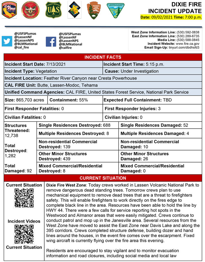
Evening Update Per CAL FIRE: California Dixie Fire is at 865,703 Acres, with 55% Containment, and 3,903 personnel assigned for Thursday evening.
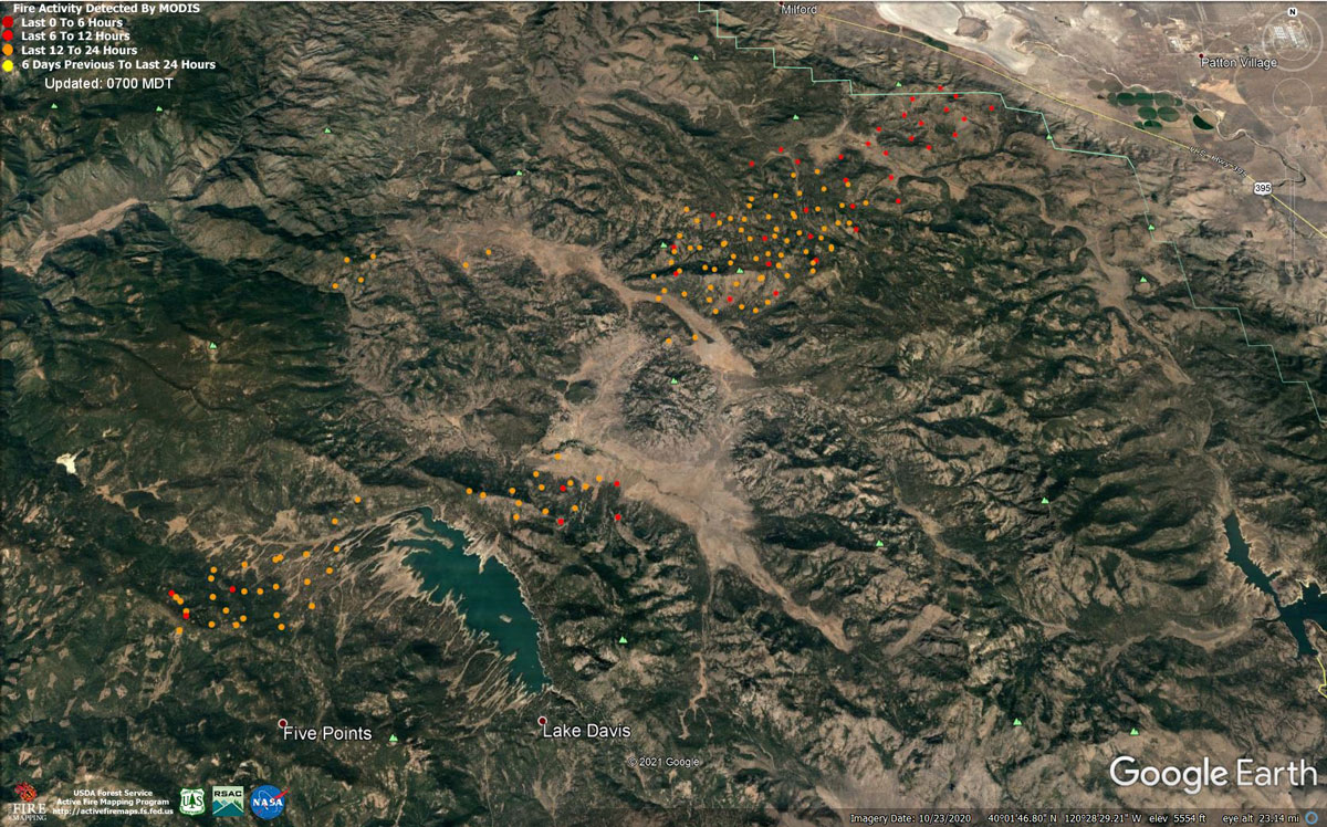
MODIS map of the Dixie Fire on Thursday at 6:00 A.M PST
Note: 1,200 Pixels Wide - Note: Older Yellow not shown
MODIS Active Fire Mapping Program Frequently Asked Questions
Update: Dixie Fire East Zone Morning Operations Briefing Video for Thursday, September 2, 2021
Update: Smoke/Air Quality Outlook for the Dixie Fire in the Eastern Sierra for Thursday, September 2, 2021
September 2, 2021 - Dixie Fire is 859,457 acres and 55% contained for Thursday morning.
Basic Information
| Current as of | 9/2/2021, 7:17:29 AM |
| Incident Type | Wildfire |
| Cause | Under Investigation |
| Date of Origin | Tuesday July 13th, 2021 approx. 05:15 PM |
| Location | Feather River Canyon near Cresta Powerhouse and Lake Almanor. |
| Incident Commander | Nick Truax, CALFIRE IMT 1 Evans Kuo, GBT1 Jay Lusher, NPS/BLM |
| Incident Description | Wildfire |
| Coordinates | 39.819 latitude, -121.419 longitude |
Current Situation
| Total Personnel | 3,997 |
| Size | 859,457 Acres |
| Percent of Perimeter Contained | 55% |
| Estimated Containment Date | Saturday October 30th, 2021 approx. 12:00 AM |
| Fuels Involved |
Fuel moistures are historically low, ERCs and BI are in the 97-99%. Northern California remains under a Fuels and Fire Behavior Advisory. |
| Significant Events |
Extreme Wind Drive Runs Group Torching Short-range Spotting Narrative: The fire activity reduced slightly over night more terrain driven winds. The fire continued to burn actively in the understory with single tree and group torching, and interior islands burning in the northern portion of the fire. The rest of the fire continued to smolder and consume the heavier materials. Smoke settled more over the fire compared to previous nights. |
Outlook
| Planned Actions |
Planned Actions for Priority areas include: the Lassen & Shasta Sectors, Old Station and surrounding communities, the highway 395 escarpment area including Janesville, Milford and Herlong Junction as well as Lake Davis and the Grizzly Creek area east of the escarpment. Communities of Greenhorn, Cromberg and Davis Lake also at risk, see "East Zone:" below. Continue to establish direct and indirect containment lines south of Old Station, utilizing lines created during the Reading incident. Resources continue to establish containment lines to hold the Hwy 44 corridor and monitor for spots across the highway, while protecting critical fiber optic infrastructure. Complete contingency lines both north and south of Janesville and Milford respectively. Monitor weather for predicted wind event in the area. Provide structure defense, while ensuring firefighter safety. Provide for service calls within communities impacted by the fire: Chester, Hwy 36 corridor, Hwy 89 Corridor, Hwy 395 corridor, Paxton, Greenville, Jonesville, Crescent Mills, Taylorsville, Prattville, Butte Meadows, Bucks Lake, Meadows Valley, Rush Creek, Warner Valley, Pecks Valley, Williams Valley, Hunt Canyon, Susanville, Janesville, and the Greater Almanor area. Continued mop up of and patrol of 1,000-hr fuels will require a significant amount of resources due to the volume of fuels and the steep and rugged terrain. Continued holding actions and point protection of communities and critical infrastructure will require a significant resource presence for the next several operational periods. East Zone: Efforts will continue focusing on extending dozer line down Grizzly Ridge and tie into the shore of Lake Davis to keep the fire away from Hwy 70 corridor. Crews will continue tactical firing operations down Grizzly Ridge as required to keep fire from impacting the communities of Sloat and Lake Davis. Structure protection remains in place within Genesee and Taylorsville. Resources will construct dozer line from Lake Davis to Clover Valley, and then further north, to keep fire from spreading east towards Dixie Valley structures. Develop a coordinated plan with the West Zone to keep fire from impacting Milford and Highway 395. Construct direct and indirect containment lines where there are opportunities to reduce spread to the east. |
| Projected Incident Activity |
12 hours: Southwest winds anticipated to continue downward trend in velocity, with a few afternoon wind gusts approaching 20 mph. Active fire behavior expected due to low relative Humidity and historically dry fuels. 24 hours: Light, terrain driven winds are expected. Southwest winds predicted to return, ridges variable with a north to northeast wind. Conditions overall to remain very dry with critically low relative humidity values during the day and poor to moderate mid-slope recoveries. 48 hours: A more typical southwest wind pattern expected into early next week. Temperatures predicted to fall several degrees beginning Thursday, with relative humidity remaining low. Dry conditions will continue into early next week with some clouds returning Monday. Active to Extreme fire behavior predicted to continue due to persistent wind and dry fuel conditions. A few clouds could return with slight chances for showers and isolated thunderstorms returning Tuesday, but the chance of a wetting rain remains low. 72 hours: A more typical southwest wind pattern expected into early next week. Temperatures predicted to fall several degrees beginning Thursday, with relative humidity remaining low. Dry conditions will continue into early next week with some clouds returning Monday. Active to Extreme fire behavior predicted to continue due to persistent wind and dry fuel conditions. A few clouds could return with slight chances for showers and isolated thunderstorms returning Tuesday, but the chance of a wetting rain remains low. Anticipated after 72 hours: Warming and drying return, and the wind is expected to increase over the weekend. Some clouds may actually cross over the incident on Friday night and Saturday. Neither rain nor thunderstorms are expected for the next week. Potential for active fire behavior due to winds and very dry fuels. |
| Remarks |
Box 4: Great Basin Incident Management Team 1 (GBT1) is in command of the East Zone. East Zone Unified Command Agencies: Plumas National Forest and Lassen National Forest CAL FIRE IMT 1 is in command of the West Zone. West Zone Unified Command Agencies: Bureau of Land Management, CAL FIRE, Lassen National Forest, National Park Service. Box 7: State DPA-132,109 Federal DPA-647,139 National Parks DPA-64,225 Local DPA-424 DOD DPA-3 Box 25: The fire area is in portions of Butte, Lassen, Plumas, Shasta, and Tehama counties. Active fronts are in Lassen NF, and Lassen NP, the communities of Genesee, Taylorsville and Old Station as well as on several private timber ownerships. Box 31 Evacuation Orders issued for Plumas and Shasta Counties. Evacuation Orders reduced to Evacuation Warnings in Tehama County. No Evacuation Orders or Warnings in Butte County. Box 32(E): East Zone - 3 responder injury, West Zone - 3 responder injuries Box 33: A State of Emergency for Butte, Lassen, and Plumas counties was declared by Governor Newsom on July 23rd, 2021. Butte, Lassen, Plumas, and Tehama Counties have declared local emergencies. FMAG has been approved for the Dixie Incident. Regional Order No. 21-04, effective August 22, 2021 through September 6, 2021, closes eight National Forests including Plumas, Lassen. The Plumas National Forest implemented Forest Order No. 05-11-00-21-18, effective from July 25, 2021, through September 30, 2021. The Lassen National Forest implemented Forest Order No. 06-21-07, effective from July 27, 2021, through September 30, 2021. Box 38: Additional values at risk threatened: National Scenic and Historic Trails: Pacific Crest Trail, Bizz Johnson National Recreation Trail Inventory Roadless Area (IRAs): Bucks Lake (PNF), Butt Mountain (PNF), Chips Creek (LNF), and Cub Creek (LNF). Experimental Forests: Swain Mountain, Blacks Mountain. Research Natural Areas (RNAs): Green Island Lake(LNF), Soda Ridge (LNF), Cub Creek (LNF), Mount Pleasant (PNF). Air Quality impacts: Reno, Carson City, Susanville, Sparks, Fernley and Quincy. Airports impacted by TFR and smoke impacts: Rogers Field (Chester Airport), Ganser Field (Quincy Airport), Westwood Airport, Susanville Municipal Airport, Herlong Airport Wilderness: Bucks Lake Wilderness (PNF), Caribou Wilderness (LNF), Lassen Volcanic National Park Wilderness. Commercial timber ownerships: Sierra Pacific Industries, W.M. Beaty and Associates, Collins Pine. An estimated $1 Billion dollars of timber has already been destroyed with an additional $1 Billion still threatened. Substantial losses of private and public timberlands have released decades of sequestered carbon, releasing it into the atmosphere with uncalculatable impacts to green house gas accumulations. Waterways: Philbrook Lake (PG&E, LNF), North Fork of the Feather River (PG&E, PNF), Silver Lake (Drinking water, PNF), Thompson Lake (Drinking water, PNF), Butte Creek (T&E species: chinook and steelhead, PNF), Deer Creek (T&E species: chinook and steelhead), Oliver Lake (T&E species: Sierra-Nevada Yellow-legged Frog, LNF), Gold Lake (T&E species: Sierra-Nevada Yellow-legged frog, PNF), Rock Lake (T&E species: Sierra-Nevada Yellow-legged frogs, PNF) Additional T&E species (not listed above): California Spotted Owl, Valley Elderberry Beetle, Shasta Crayfish, Cascades frog, California Red-Legged Frog, Bald Eagle, Golden Eagle, Grey wolf, Fisher, California wolverine, and Sierra Nevada red fox. Box 49: Database reconciliation is ongoing to correct resource discrepancies in the IROC and Isuite databases |
Current Weather
| Weather Concerns |
Weather Concerns (synopsis of current and predicted weather; discuss related factors that may cause concern): Winds expected to subside overnight across the fire area, except in the southeast near US-395. Extreme fire behavior predicted to continue due to persistent wind and dry fuel conditions; near red flag conditions. Smoke to filtered into the valleys and RH recoveries should be poor to moderate. Temperatures forecasted into the lower 30s in some valleys but mid and upper slopes to remained in the lower 50s. |
Click here for: California Dixie Fire Wednesday, September 1, 2021 Updates
