


Note: Click Here for Dixie Fire Monday Updates
Update: Dixie Fire West Zone Virtual Community Meeting Evening Update Video for Sunday, September 5, 2021
Update: Dixie Fire East Zone Evening Operations Briefing Video for Sunday, September 5, 2021
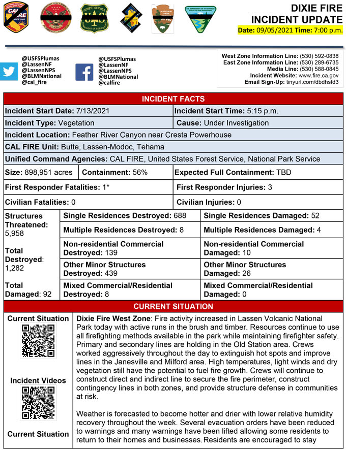
Evening Update Per CAL FIRE: California Dixie Fire is at 898,951 Acres, with 56% Containment, and 3,847 personnel assigned for Sunday evening.
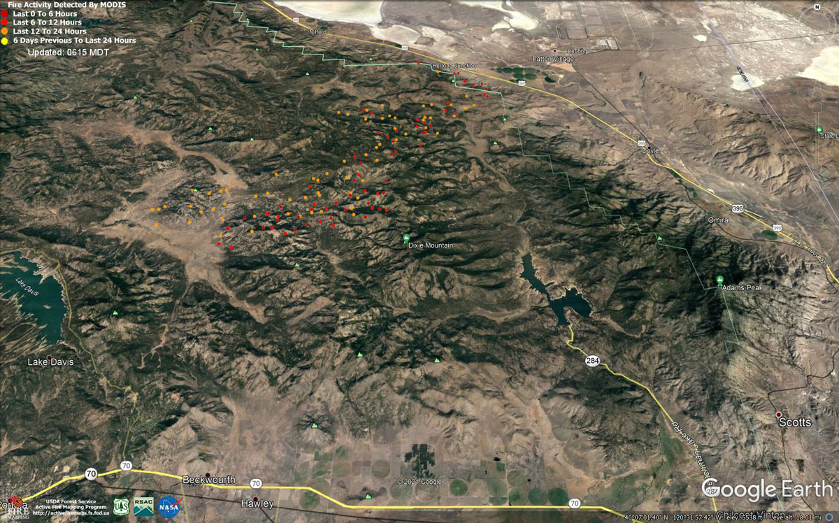
MODIS map of the Dixie Fire on Sunday at 5:15 A.M PST
Note: 1,200 Pixels Wide - Note: Older Yellow not shown
MODIS Active Fire Mapping Program Frequently Asked Questions
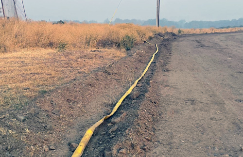
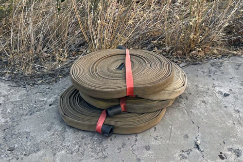
Reminder: Do you have fire hose or other firefighting equipment left on your property by the Dixie firefighters? If so, tell us via email or phone, and we will come and pick up the equipment. Please provide your physical address and any concerns accessing the property.
Contact: E-mail: DixieFire2021@gmail.com Subject: Dixie Fire Equipment or Phone: 530-592-0838.
Update: Dixie Fire West Zone Operations Morning Briefing Video for Sunday, September 5, 2021
Update: Dixie Fire East Zone Morning Operations Briefing Video for Sunday, September 5, 2021
Update: Smoke/Air Quality Outlook for the Dixie Fire in the Eastern Sierra for Sunday, September 5, 2021
September 5, 2021 - Dixie Fire is 893,852 acres and 56% contained for Sunday morning.
Update:
Dixie Fire Update for Sunday, September 5, 2021
893,852 Acres
56% Containment3,803 Total Personnel
Dixie Fire West Zone - The fire continues to burn out in the heavy material and was moderated by the smoke settling over the fire area. Active fire was limited to ground fuels, consisting of backing and flanking fire. Interior pockets continue to burn through the night, most are well interior of the perimeter. The diminishing humidity recovery aided in consumption of the heavier fuels. The southeast flank of the fire continues to burn in multiple directions due to varying winds. Crews continue to fight fire aggressively, construct and reinforce control lines, and protect structures. Mop up efforts have begun where appropriate. Light downslope and drainage wind this morning will transitions to a light west southwest wind along ridgetops this afternoon with lighter terrain driven winds in the sheltered valleys. A warming trend continues over the area with highs in the 80’s to low 90’s in the valleys as high pressure takes hold over the area. Heavy smoke will continue to hamper visibility throughout the day as it is trapped under high pressure. The smoke will be in the fire area longer and may limit air operations throughout the day.
Lassen and Plumas National Forests — A high pressure system will maintain stable hot and dry weather creating smokey conditions today. Very dry fuel conditions and shifting winds will cause potential for rapid fire spread resistant to containment. Yesterday, shifting winds challenged firefighters, and the fire progressed southeast in the Coyote Hills, Horton Ridge, and Ross Canyon areas into very dry and dense forest fuels. Spot fires became established in Ross Canyon and off Horton Ridge threatening Dixie Valley. Crews will build line and protect structures by removing brush, building indirect fireline, and installing hose systems. Aircraft will assist those ground crews. Overnight, fire reached the base of the escarpment along Highway 395. Air and ground crews will work closely with firefighters from the West Zone to reinforce firelines today. On Turner Ridge, crews are securing the line and mopping up heat with water. Resources continue to hold and improve dozer and handline stretching from Clover Valley to the east side of Lake Davis, and patrol and monitor the long and now mostly cold line on Grizzly Ridge. South of Taylorsville, crews will continue to build depth on established lines and cool interior heat in the very steep terrain north and south of Montgomery Creek. Structure protection continued overnight within Clover Valley, Dixie Valley, Genesee, Taylorsville, Greenhorn, and Cromberg. Residents are encouraged to stay vigilant and to monitor evacuation information and road closures, including social media and local law enforcement websites for the most current information. Residents will see smoke coming from trees and stumps for days following their return. Proceed with caution because burned out areas may have unseen hazards. Residents are encouraged to call 911 if they are concerned about any active flames near their homes or businesses. Damage assessment remains ongoing. Change in threatened structures due to new Evacuation Warnings in Lassen, Plumas and Shasta County. ·A firefighter assigned to the Dixie incident passed away on September 2, due to an illness.
CAL FIRE
'Click' here to view full PDF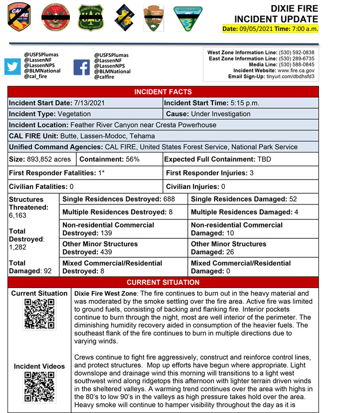
Basic Information
| Current as of | 9/5/2021, 7:00:35 AM |
| Incident Type | Wildfire |
| Cause | Under Investigation |
| Date of Origin | Tuesday July 13th, 2021 approx. 05:15 PM |
| Location | Feather River Canyon near Cresta Powerhouse and Lake Almanor. |
| Incident Commander | Nick Truax, CALFIRE IMT 1 Evans Kuo, GBT1 Jay Lusher, NPS/BLM |
| Incident Description | Wildfire |
| Coordinates | 39.819 latitude, -121.419 longitude |
Current Situation
| Total Personnel | 3,820 |
| Size | 893,852 Acres |
| Percent of Perimeter Contained | 56% |
| Estimated Containment Date | Saturday October 30th, 2021 approx. 12:00 AM |
| Fuels Involved |
Fuel moistures are historically low, ERCs and BI are in the 97-99%. Northern California remains under a Fuels and Fire Behavior Advisory. |
| Significant Events |
Extreme Wind Drive Runs Group Torching Short-range Spotting Narrative: The fire continues to burn out in the heavy material and was moderated by the smoke settling over the fire area. Active fire was limited to ground fuels, consisting of backing and flanking fire. Interior pockets continue to burn through the night, most are well interior of the perimeter. The diminishing humidity recovery aided in consumption of the heavier fuels. The southeast flank of the fire continues to burn in multiple directions due to varying winds. Short range spotting is occurring in areas where terrain and winds align. |
Outlook
| Planned Actions |
Planned Actions for the next Operational Period: Priority areas include: the Lassen & Shasta Sectors, Old Station and surrounding communities, the highway 395 escarpment area including Janesville, Milford and Herlong Junction as well as Lake Davis and the Grizzly Creek area east of the escarpment. Communities of Greenhorn, Cromberg and Davis Lake also at risk, see "East Zone:" below. Continue to establish direct and indirect containment lines south of Old Station, utilizing lines created during Provide for service calls within communities impacted by the fire: Chester, Hwy 36 corridor, Hwy 89 Corridor, Hwy 395 corridor, Paxton, Greenville, Jonesville, Crescent Mills, Taylorsville, Prattville, Butte Meadows, Bucks Lake, Meadows Valley, Rush Creek, Warner Valley, Pecks Valley, Williams Valley, Hunt Canyon, Susanville, Janesville, and the Greater Almanor area. Continued mop up of and patrol of 1,000-hr fuels will require a significant amount of resources due to the volume of fuels and the steep and rugged terrain. Continued holding actions and point protection of communities and critical infrastructure will require a significant resource presence for the next several operational periods. East Zone: Resources will continue hold and improve dozer and handline from Lake Davis to Clover Valley, and then further north, to keep fire from spreading east towards Dixie Valley and north towards Milford, as well as south towards Clover Valley and Portola. Construct direct and indirect containment lines on the flanks of the fire edge to prevent fire from impacting Milford and Highway 395. Structure protection remains in place within Genesee and Taylorsville. Critical resources identified in Block 39 are required to manage operational span of control, enhance safety, and accomplish delegated requirements from cooperating agencies. |
| Projected Incident Activity |
12 hours: Light downslope and weak winds aloft kept thick smoke in place over the fire area reducing visibility in many valleys. Moderate RH recoveries in the 30-35% range were observed with temperatures dropping into the mid to upper 30s in some valleys but mid and upper slopes remained in the lower to mid 50s. Afternoon humidity lower in most locations below 10 percent. 24 hours: High pressure will sustain above normal temperatures with some lower valleys reaching the 90s Monday along with a very dry air mass remaining in place, resulting in critically low afternoon minimum RH values and poor to moderate mid-slope recoveries through Tuesday. Temperatures will begin to decrease slightly Tuesday into the mid 80s. Light west to southwest wind is expected until a weather disturbance moves into the area until Tuesday, when a more active weather pattern is possible starting midweek with increasing gusty winds. Moderate to active fire behavior and moderate growth expected. 48 hours: High pressure will sustain above normal temperatures with some lower valleys reaching the 90s Monday along with a very dry air mass remaining in place, resulting in critically low afternoon minimum RH values and poor to moderate mid-slope recoveries through Tuesday. Temperatures will begin to decrease slightly Tuesday into the mid 80s. Light west to southwest wind is expected until a weather disturbance moves into the area until Tuesday, when a more active weather pattern is possible starting midweek with increasing gusty winds. Moderate to active fire behavior and moderate growth expected. 72 hours: High pressure will sustain above normal temperatures with some lower valleys reaching the 90s Monday along with a very dry air mass remaining in place, resulting in critically low afternoon minimum RH values and poor to moderate mid-slope recoveries through Tuesday. Temperatures will begin to decrease slightly Tuesday into the mid 80s. Light west to southwest wind is expected until a weather disturbance moves into the area until Tuesday, when a more active weather pattern is possible starting midweek with increasing gusty winds. Moderate activity and minimal growth expected. Anticipated after 72 hours: High pressure will sustain above normal temperatures with some lower valleys reaching the 90s Monday along with a very dry air mass remaining in place, resulting in critically low afternoon minimum RH values and poor to moderate mid-slope recoveries through Tuesday. Temperatures will begin to decrease slightly Tuesday into the mid 80s. Light west to southwest wind is expected until a weather disturbance moves into the area until Tuesday, when a more active weather pattern is possible starting midweek with increasing gusty winds. Moderate activity and minimal growth expected. |
| Remarks |
Box 4: Great Basin Incident Management Team 1 (GBT1) is in command of the East Zone. East Zone Unified Command Agencies: Plumas National Forest and Lassen National Forest CAL FIRE IMT 1 is in command of the West Zone. West Zone Unified Command Agencies: Bureau of Land Management, CAL FIRE, Lassen National Forest, National Park Service. Box 7: State DPA- 132,099; Federal DPA- 687,858; National Parks DPA- 65,569; Local DPA- 424; DOD DPA- 3 Box 25: The fire area is in portions of Butte, Lassen, Plumas, Shasta, and Tehama counties. Active fronts are in: Lassen NF, Lassen NP, and the Caribou Wilderness area; the lake Davis and Antelope Lake area; highway 395 adjacent to Honey Lake area, as well as on several private timber ownerships. Box 31 (J): Indoor - 16 Outdoor - 6 Box 32 (D) : 1 fatality - this individual was previously identified as ill, passed away on the afternoon of September 2nd. Box 32(E): East Zone - 5 responder injury, West Zone - 3 responder injuries Box 33: A State of Emergency for Butte, Lassen, and Plumas counties was declared by Governor Newsom on July 23rd, 2021. Butte, Lassen, Plumas, and Tehama Counties have declared local emergencies. FMAG has been approved for the Dixie Incident. Regional Order No. 21-04, effective August 22, 2021 through September 6, 2021, closes eight National Forests including Plumas, Lassen. The Plumas National Forest implemented Forest Order No. 05-11-00-21-18, effective from July 25, 2021, through September 30, 2021. The Lassen National Forest implemented Forest Order No. 06-21-07, effective from July 27, 2021, through September 30, 2021. Box 38: Additional values at risk threatened: National Scenic and Historic Trails: Pacific Crest Trail, Bizz Johnson National Recreation Trail Inventory Roadless Area (IRAs): Bucks Lake (PNF), Butt Mountain (PNF), Chips Creek (LNF), and Cub Creek (LNF). Experimental Forests: Swain Mountain, Blacks Mountain. Research Natural Areas (RNAs): Green Island Lake(LNF), Soda Ridge (LNF), Cub Creek (LNF), Mount Pleasant (PNF). Air Quality impacts: Reno, Carson City, Susanville, Sparks, Fernley and Quincy. Airports impacted by TFR and smoke impacts: Rogers Field (Chester Airport), Ganser Field (Quincy Airport), Westwood Airport, Susanville Municipal Airport, Herlong Airport Wilderness: Bucks Lake Wilderness (PNF), Caribou Wilderness (LNF), Lassen Volcanic National Park Wilderness. Commercial timber ownerships: Sierra Pacific Industries, W.M. Beaty and Associates, Collins Pine. An estimated $1 Billion dollars of timber has already been destroyed with an additional $1 Billion still threatened. Substantial losses of private and public timberlands have released decades of sequestered carbon, releasing it into the atmosphere with uncalculatable impacts to green house gas accumulations. Waterways: Philbrook Lake (PG&E, LNF), North Fork of the Feather River (PG&E, PNF), Silver Lake (Drinking water, PNF), Thompson Lake (Drinking water, PNF), Butte Creek (T&E species: chinook and steelhead, PNF), Deer Creek (T&E species: chinook and steelhead), Oliver Lake (T&E species: Sierra-Nevada Yellow-legged Frog, LNF), Gold Lake (T&E species: Sierra-Nevada Yellow-legged frog, PNF), Rock Lake (T&E species: Sierra-Nevada Yellow-legged frogs, PNF) Additional T&E species (not listed above): California Spotted Owl, Valley Elderberry Beetle, Shasta Crayfish, Cascades frog, California Red-Legged Frog, Bald Eagle, Golden Eagle, Grey wolf, Fisher, California wolverine, and Sierra Nevada red fox. Box 49: Database reconciliation is ongoing to correct resource discrepancies in the IROC and Isuite databases |
Current Weather
| Weather Concerns |
Weather Concerns : Very light terrain driven winds less than 10 mph were present across much of the area through the late morning and early afternoon hours. A light west to southwest wind developed across the western periphery of the fire area but winds continued to be predominantly light and terrain driven during the afternoon farther east. Lighter winds aloft allowed smoke to remain trapped across the area resulting in poor visibility through the day. Due to the warming trend, temperatures increased from yesterday into the mid 80s and some low 90s in valleys. Increasing temperatures were mitigated some due to smoke shading. Dry conditions continued with moderate RH recoveries falling to around 10% in the afternoon. |
Click here for: California Dixie Fire Saturday, September 4, 2021 Updates
