


Note: Click Here for Tuesday Caldor Fire Updates
Update: Caldor Fire Virtual Briefing & Community Meeting Evening Update Video for Monday, September 6, 2021
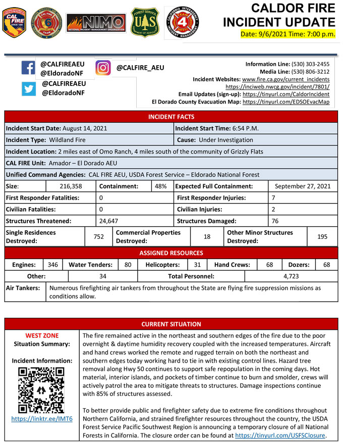
Evening Update Per CAL FIRE: California Caldor Fire is at 216,358 Acres, with 48% Containment, and 4,723 personnel assigned for Monday evening.
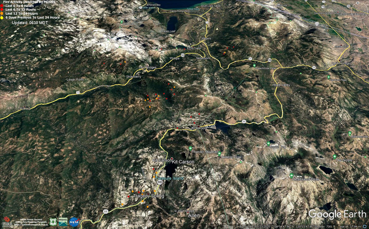
MODIS map of the Caldor Fire on Monday at 5:30 A.M PST
Note: 1,200 Pixels Wide - Note: Older Yellow not shown
MODIS Active Fire Mapping Program Frequently Asked Questions
Update: Smoke/Air Quality Outlook for the California Caldor Fire for Monday, September 6, 2021
Update: California Caldor Fire Infrared Map for Monday, September 6, 2021
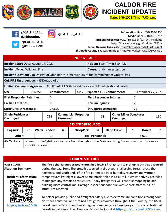
September 6, 2021 - Caldor Fire Update for Monday Morning, 216,358 Acres with 44% Containment.
Update CAL FIRE
Basic Information
| Current as of | 9/6/2021, 8:06:02 AM |
| Incident Type | Wildfire |
| Cause | Under Investigation |
| Date of Origin | Saturday August 14th, 2021 approx. 07:00 PM |
| Location | 4 miles South of Grizzly Flats, 2 miles East of Omo Ranch |
| Incident Commander | Jeff Veik, CAL FIRE IMT6; Joe Reinarz, USFS NIMO 2; Rocky Oplinger, ICT1, USFS CIIMT4 |
| Coordinates | 38.584 latitude, -120.534 longitude |
Current Situation
| Total Personnel | 5,072 |
| Size | 216,358 Acres |
| Percent of Perimeter Contained | 44% |
| Estimated Containment Date | Monday September 27th, 2021 approx. 06:00 PM |
| Fuels Involved |
Timber (litter and understory) Light logging slash Brush (2 feet) |
| Significant Events |
WEST ZONE: The fire behavior moderated overnight allowing for spot fires that occurred during the day shift to be acted. Fire growth still only occurred in Div I and Div N. Single and group tree torching of interior islands was observed. The poor humidity recovery and warmer temperatures were a big factor for this activity to continue. Interior smoldering and the release of fire weakened timber continued across all divisions. The inversion again formed over the incident overnight which will limit activity in the early hours but will burn off quickly once morning comes and the winds shifts occur. EAST ZONE: Several days of moderated weather have assisted crews with progress in reaching containment objectives. Fuel moistures remain critically low for both live and dead fuels. SW winds are forecasted for mid next week. SW winds are associated with large fire growth. The Energy Release Component is above the 97th percentile. The Burning Index is just above the 90th percentile. Potential for wind driven surface fire due to alignment. Expected most of the fire growth to be to the north and northeast. Expect an increase in fire activity with clear air. Fire behavior moderated the previous shift, expect similar fire activity. |
Outlook
| Planned Actions |
WEST ZONE: Provide for the life safety of citizens and emergency responders. Implement structure and critical infrastructure defense. Construct control lines and take advantage of targets of opportunity as allowed by fire behavior and resource limitations. Improve and hold established control lines. Prepare for firing operations and implement burn plans. Identify and establish contingency lines. Tactical patrol of perimeter contained. Heavy mop-up, backhaul of hose, and patrol will continue in areas of DIV A and D. Contingency lines will continue to be constructed in DIV I, and Contingency Branch from Ice House east to the DIV I break. Preparations for potential firing opportunities will occur in DIV N and P. Fire Suppression Repair continues to evaluate repair needs and will implement the Incident's Fire Suppression Repair Plan. EAST ZONE: In the Christmas Valley area crews will remain engaged in strengthening direct containment lines with aggressive mop up from Highway 89 west to Scout Peak to reduce the threat to structures. In the Pioneer Trail area, resources will continue to patrol and mop up as necessary. On the northeastern side of the fire, resources will strengthen existing fireline and continue to use a combination of direct and indirect tactics. On the southern flank of the eastern finger of the fire, a combination of direct hand and dozer line is being constructed to keep fire from moving to the south and east. In the northwest part of the zone, crews will continue to construct direct fireline from Highway 50 toward Lower Echo Lake. In the Lower and Upper Echo Lake areas, structure prep and line construction operations are ongoing. In the Caples Lake area crews will continue to extend direct fireline to the northwest toward the dozer line. A wildland fire module has been inserted into the Desolation Wilderness to contain the northwestern corner of the East Zone. A heli-rappel module will be inserted next shift and additional wildland fire modules are on order for this area. A contingency group is building contingency lines to the northeast of the fire in the event of fire crossing primary containment lines. Mastication and chipping are occurring on road systems south of the east zone of the fire. Crews are also masticating roads in the Fallen Leaf Lake area for contingency purposes. Planning has occurred to mitigate potential threat to communities in the Foothill Road area east of the fire in the event of continued fire spread to the northeast. |
| Projected Incident Activity | |
| Remarks |
A Fire Management Assistance Declaration was declared on August 17, 2021. Incident Period: August 14, 2021, and continuing. (FM-5413-CA) The Governor of California declared a State of Emergency for El Dorado County on August 17, 2021, due to the Caldor Fire. The Eldorado National Forest is closed from August 17, 2021, through September 30, 2021. (Forest Order No. 03-21-14) To better provide public and firefighter safety due to the ongoing California wildfire crisis, USDA Forest Service Pacific Southwest Region announced a temporary closure of all National Forests in California from Aug. 31, 2021 through September 17, 2021. CAL FIRE IMT-6 and NIMO-2 are in command of the West Zone and CIIMT-4 is in command of the East Zone. CAL FIRE IMT-2 will transition with CAL FIRE IMT-6 and assume command on Wednesday, Sept 8th at 0700 hours. Fuels reduction projects that have been implemented around the community of South Lake Tahoe have been highly effective in providing opportunities for resources to successfully suppress fire. |
Current Weather
| Weather Concerns |
WEST ZONE: Observed: Inversion conditions set up again around 2100 and continued through the night. Downslope and down canyon winds developed at around 2100 and prevailed through the night. Lows ranged from 52-62 over the higher elevations to 62-68 in lower drainages. Relative humidity was poor reaching only the 18-24 percent range. Forecast for Monday: Sunny with areas of smoke. Inversion breaking by 1200. Highs 74-84 upper elevations and 84-93 lower drainages. Minimum relative humidity 8-13 percent. Winds downslope/down canyon 4-8 mph with gusts to 13 mph through 0900 then becoming southwest to west 6-11 mph with gusts to 18 mph except gusts to 25 mph along the Highway 50 corridor. East Zone: Observations: Strong inversions formed overnight with very poor humidity recoveries above 6800', only reaching 18 to 26% along the mid-slopes and ridgelines. Good recoveries occurred in the lower valleys with temperatures in the upper 30s to low 40s. Ridge winds remained variable with downslope, terrain driven winds, over the rest of the fire area. Monday Forecast: Extremely dry air will remain over the fire area on Monday with above average temperatures continuing through Monday as high pressure remains over the west. Humidities will drop into the low to mid-teens at all elevations again during the day with very poor recoveries on mid-slopes and ridges. Light ridge winds in the morning will become westerly during the afternoon. Surface winds remain terrain driven with upslope winds 4 to 8 mph during the afternoon and gusts up to 15 mph in canyons. |
Click here for: California Caldor Fire Sunday, September 5, 2021 Updates
