


Note: Click here for Caldor Fire Friday Updates
Update: Caldor Fire Virtual Briefing & Community Meeting Evening Update Video for Thursday, September 9, 2021
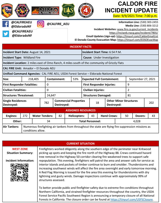
Evening Update Per CAL FIRE: California Caldor Fire is at 218,405 Acres, with 53% Containment, and 4,028 personnel assigned for Thursday evening.
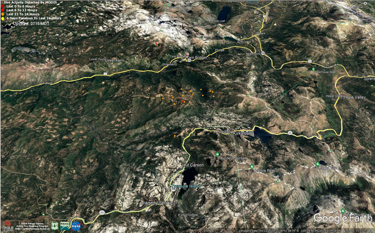
MODIS map of the Caldor Fire on Thursday at 6:15 A.M PST
Note: 1,200 Pixels Wide - Note: Older Yellow not shown
MODIS Active Fire Mapping Program Frequently Asked Questions
Update: California Caldor Fire Infrared Map for Thursday, September 9, 2021
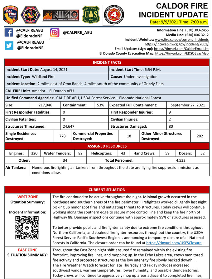
September 9, 2021 - Caldor Fire Update for Thursday Morning, 217,946 Acres with 53% Containment.
Update CAL FIRE
Basic Information
| Current as of | 9/9/2021, 7:20:43 AM |
| Incident Type | Wildfire |
| Cause | Under Investigation |
| Date of Origin | Saturday August 14th, 2021 approx. 07:00 PM |
| Location | 2 Miles East of Omo Ranch, 4 miles South of Grizzly Fla |
| Incident Commander | Jeff Veik, CAL FIRE IMT6; Joe Reinarz, USFS NIMO 2; Rocky Opliger, ICT1, USFS CIIMT4 |
| Coordinates | 38.586 latitude, -120.538 longitude |
Current Situation
| Total Personnel | 4,820 |
| Size | 217,946 Acres |
| Percent of Perimeter Contained | 53% |
| Estimated Containment Date | Monday September 27th, 2021 approx. 06:00 PM |
| Fuels Involved |
Timber (litter and understory) Light logging slash Brush (2 feet) |
| Significant Events |
WEST ZONE: The fire continued to remain active in the Div I and Div N areas due to the poor overnight and daytime humidity recovery coupled with the high daytime temperatures. Short range spotting continue to occur along Hwy 88 and within interior islands due to the Probability of Ignition remaining at 89%. Hot material continues to be found near the control lines in the north and eastern divisions. Interior islands and stringers of timber continued to burn out. No growth occurred in the south, west, and northwest areas. Increase in calls for service in the recently repopulated areas. EAST ZONE: Several days of moderated weather have assisted crews with reaching containment objectives. Southwest wind forecasted for today. Fuel moistures remain critically low for both live and dead fuels. SW winds are forecasted for next week and are associated with large fire growth. The Energy Release Component is above the 97th percentile. The Burning Index is just above the 90th percentile. Potential for wind-driven surface fire due to alignment. Expect most of the fire growth to be to the north and northeast. Expect an increase in fire activity with clear air. Fire behavior moderated the previous shift, expect similar fire activity. |
Outlook
| Planned Actions |
WEST ZONE: Provide for the life safety of citizens and emergency responders. Implement structure and critical infrastructure defense. Construct control lines and take advantage of targets of opportunity as allowed by fire behavior and resource limitations. Improve and hold established control lines. Prepare for firing operations and implement burn plans. Identify and establish contingency lines. Tactical patrol of perimeter contained. Heavy mop-up, backhaul of hose, and patrol will continue in areas of DIV A and D. Contingency lines will continue to be constructed in DIV I, and Contingency Branch from Ice House east to the DIV I break. Preparations for potential firing opportunities will occur in DIV N and P. MIST tactics will be used in the Desolation Wilderness. Fire Suppression Repair continues to evaluate repair needs and will implement the Incident's Fire Suppression Repair Plan. EAST ZONE: In the Christmas Valley area crews will remain engaged in strengthening direct containment lines with aggressive mop up from Highway 89 west to Scout Peak to reduce the threat to structures. In the Pioneer Trail area, resources will continue to patrol and mop up as necessary and mitigate hazards in preparation for repopulation. On the northeastern side of the fire, resources will strengthen existing fireline and continue to use a combination of direct and indirect tactics. |
| Projected Incident Activity | |
| Remarks |
A Fire Management Assistance Declaration was declared on August 17, 2021. Incident Period: August 14, 2021, and continuing. (FM-5413-CA) The Governor of California declared a State of Emergency for El Dorado County on August 17, 2021, due to the Caldor Fire. The Eldorado National Forest is closed from August 17, 2021, through September 30, 2021. (Forest Order No. 03-21-14) To better provide public and firefighter safety due to the ongoing California wildfire crisis, USDA Forest Service Pacific Southwest Region announced a temporary closure of all National Forests in California from Aug. 31, 2021 through September 17, 2021. CAL FIRE IMT-6 and NIMO-2 are in command of the West Zone and CIIMT-4 is in command of the East Zone. CAL FIRE IMT-2 has transitioned with CAL FIRE IMT-6 and will assume command of the West Zone on Wednesday, Sept 8th at 0700 hours. Fuels reduction projects that have been implemented around the community of South Lake Tahoe have been highly effective in providing opportunities for resources to successfully suppress fire. |
Current Weather
| Weather Concerns |
WEST ZONE: Observed: The inversion over the fire area broke around 0900 this morning with a very dry air mass. Temperatures reached mid-80's to lower 90's at higher elevations and the mid-90's at lower elevations. Relative humidity values ranged from 14% to 21% by 1400. Winds were generally out of the west 5-10 MPH with gusts to 14 MPH. Forecast for tonight: Clear with areas of smoke. Inversions setting in after 2000 and persisting through the night. Temperatures will drop to 57-67 at the highest elevations and 70 to 80 in the lower elevations. Humidity recovery poor at 25-35 percent. Winds becoming downslope/downcanyon 4-9 MPH with gusts to 13 MPH in deepest drainages. EAST ZONE: Observations: High pressure and very dry air remained over the region with humidities dropping into the upper teens throughout the fire area again today. Ridge level wind were calm this morning and picked up out of the west and southwest with gusts around 20 mph in the afternoon. Surface winds were terrain driven over the fire, upslope and upcanyon during the day, with gusts around 15 mph in the late afternoon. Wednesday Forecast: Dry and warm conditions will remain over the fire area on Wednesday with above average temperatures continuing as high pressure remains over the west. Humidities will drop into the mid-teens at all elevations again during the day with poor recoveries on mid-slopes and ridges. Light ridge winds in the morning will become westerly during the afternoon. Surface winds remain terrain driven with upslope winds 4 to 8 mph during the afternoon and gusts up to 15 mph in canyons. |
Click here for: California Caldor Fire Wednesday, September 8, 2021 Updates
