


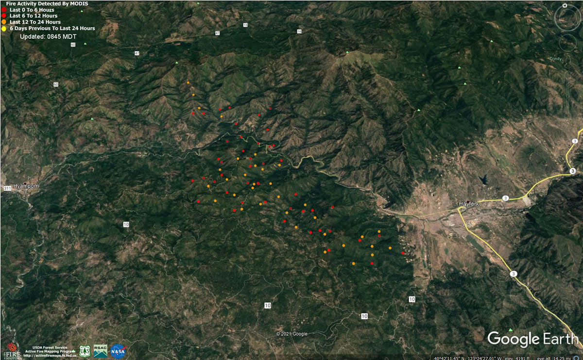
MODIS map of the Monument Fire on Thursday at 7:45 A.M PST
Note: 1,200 Pixels Wide - Note: Older Yellow not shown
MODIS Active Fire Mapping Program Frequently Asked Questions
Evening Update Per CAL FIRE: Monument Fire is at 204,436 Acres with 45% Containment, and 1,525 Personnel assigned for Thursday evening.
Basic Information
| Current as of | 9/9/2021, 6:21:53 PM |
| Incident Type | Wildfire |
| Cause | Lightning |
| Date of Origin | Friday July 30th, 2021 approx. 06:00 PM |
| Location | Del Loma, CA near Monument Peak |
| Incident Commander | Rick Young, ICT1 CIIMT5 and Mike Parkes, ICT1 CAL FIRE IMT |
| Incident Description | Wildfire |
| Coordinates | 40.752 latitude, -123.337 longitude |
Current Situation
| Total Personnel | 1,525 |
| Size | 204,436 Acres |
| Percent of Perimeter Contained | 45% |
| Estimated Containment Date | Monday November 01st, 2021 approx. 08:00 AM |
| Fuels Involved |
The fire remains within the 2008 Buckhorn, Eagle, Miners and Cedar Fire footprints. Converted brush and a heavy dead and downed component dominate most areas. Fuels to the north of Hayfork are characterized as widely spaced mixed conifer and grass. All live fuels are cured to levels normally seen in late September. |
| Significant Events |
Active fire behavior. High resistance to control. Fair RH recovery. Cloud cover moderated fire behavior slightly. Fire growth was primarily a function of aggressive surface fire; short, uphill runs, tree torching, short range spotting, and roll-out due to steep, complex terrain. Afternoon heating provided growth opportunities west of Hayfork towards Hyampom and south towards Indian Valley. Additional expansion continued into the well aligned topography north of the 299 corridor, within the designated wilderness, towards Green Mountain, Thurston Peaks and Hobo Gulch. East of Hoboken, fire continues to make a consistent flanking action along the south slopes of Big Mountain, towards the New River. |
Outlook
| Planned Actions |
Provide structure defense as Mitigate the imminent threats to life and private property for the communities in the following areas: Div-W/Y - Hayfork along the west side from Old Hay wagon road south to the N10 road, Drink water Gulch, and along Hayampom Road. Div- K - Hoboken, Dailey, Gray Ranch, and Denny. Div-U - structures along the East Fork Road North of Barney Gulch and structures along the Canyon Creek Road North of DP-355. Once the imminent threats to human life and private property is mitigated, actions will be focused on perimeter control as planned. |
| Projected Incident Activity |
12 hrs: Fire behavior will be slightly tempered under fair relative humidity recovery. Erratic winds may contribute to spread and spotting. Drainage winds will continue to steer established deep seated fire both west and east along the Hayfork Creek corridor; sustaining an ongoing threat to the communities of Hyampom and Hayfork. Indian Valley is threatened with any new growth south of Hayfork Creek. Continued fire activity along the south and west slopes of Big Mountain will maintain a threat to the New River corridor, and the community of Hoboken. Recent fire expansion along along the East Fork of the North Fork Trinity River now represents a threat to Hobo Gulch. 24 hrs: Slightly cooler temps and elevated humidity may slightly temper fire behavior. High resistance to control. Expect continued growth particularly where wind and topography align. Expect active burning with elongated burn periods well past sunset. Very dry large fuels and fully available fine fuels will contribute to unimpeded growth where any fuel continuity exists and suppression resources do not. Daily diurnal wind flow will again steer established deep seated fire. 24 hours: mainly along the Hayfork Creek corridor; providing an ongoing threat to the communities of Hayfork and Hyampom. Indian Valley is threatened with any new growth south of Hayfork Creek. Expect northerly spread into the high elevation wilderness below Green Mountain and Thurston Peaks. Continued active burning, north of Ironside Mountain, will represent a threat to Denny. Recent fire expansion along along the East Fork of the North Fork Trinity River now represents a threat to Hobo Gulch. |
| Remarks |
Block 48: CA-CDF row includes all resources that are assigned to the State Mission that was previously the South Zone of the Monument Fire. Resource counts: chippers and excavators have been included with Track Vehicles. All State Resources from states other than CA were consolidated under the State Column. |
Current Weather
| Weather Concerns |
Observed: Red Flag Warning in effect from 1400 until 0500 Friday morning Patchy fog in the valleys through the morning. Approaching upper level system was drawing abundant mid and high level moisture up into the fire area from the south, producing mostly cloudy skies. The cloud cover helped moderate maximum temperatures as well as minimum humidity levels through mid-afternoon. Winds were very light through much of the day, with gusty WNW winds developing by mid- afternoon over the far western sections of the fire area. Max Temperatures: Lower 80s to lower 90s Minimum Humidity: 15-25% 20 ft Winds: Upper Slopes & Ridges: ENE to ESE 1-3 mph through 1400, becoming WNW to WSW 3-5 mph gusts to 12 mph into the afternoon and evening. Trinity River Basin: Down-canyon 1-3 mph through 1200, then up-canyon 3-6 mph gusts to 10 mph into the afternoon and evening. Forecast: A couple rounds of convection are forecast for the area through the night, producing intermittent lightning as well as a high potential for gusty erratic winds. A wetting rain is not expected. Temperatures are forecast fall into the lower 50s to lower 60s across the fire, with moderate humidity recoveries. The upper level system will push to the east tomorrow, producing generally cooler temperatures and higher humidity levels under mostly sunny skies. Winds will be terrain-driven through midday, then are expected to become west-northwest and brisk with gusts of 15 to 20 mph. |
![]()
*** Monument Fire ***
NEW Hayfork Fire Evacuation Warning and Order at 9:00 A.M.
Effective: Immediately
#1 - All areas along Hyampom Road from Cedar Gulch to State Route 3 are under an Evacuation Warning. This includes Circle Drive, Highland Drive, North Vista Lane, Murray Lane and Bean Gulch and North Talco Way.
#2 - All areas south of Hyampom Road along State Route 3 to Salt Creek Growers. All areas West on Tule Creek Road from State Route 3 to Jesse Lane. These areas are now under an Evacuation Warning.
#3 - All areas east of Hyampom Road, both north and south of State Route 3 to Big Creek Road. All areas south of Big Creek Road to Morgan Hill Road/ Coonrod Gulch. From Coonrod Gulch Southwest through Kingsbury Gulch to State Route 3. This includes all of Hayfork proper.
Residents in the area if elderly, have medical issues, have small children, or have livestock and pets, need to be prepared to leave the area in case of increased fire activity.
Hyampom Road and St. John Road Evacuation Order
Effective: Immediately
All areas along Hyampom Road from Grassy Flat Road west to St. John Road are now under an Evacuation Order. This includes Bar 717 Camp. FS Rd 10/ St. John Road is closed. An alternate route for citizens in Hyampom is FS Rd 60 to Burnt Ranch.
All areas south of the intersection of FS Road 10/ St. John Road south to Sydney Lane. From Sydney Lane Northeast thru FS Road 10/ St. John Road to Oak Ridge. These areas are now under an Evacuation Order.
Residents in the area should leave immediately.
While leaving the area use caution, as emergency vehicles assisting with evacuations, structure protection, and fire suppression efforts will be on the roadways.
Source: Trinity County Sheriff's Office
September 9, 2021 - Monument Fire Update for Thursday Morning, 198,829 acres with 45% containment.
Basic Information
| Current as of | 9/9/2021, 7:29:10 AM |
| Incident Type | Wildfire |
| Cause | Lightning |
| Date of Origin | Friday July 30th, 2021 approx. 06:00 PM |
| Location | Del Loma, CA near Monument Peak |
| Incident Commander | Rick Young, ICT1 CIIMT5 and Mike Parkes, ICT1 CAL FIRE IMT |
| Incident Description | Wildfire |
| Coordinates | 40.752 latitude, -123.337 longitude |
Current Situation
| Total Personnel | 1,796 |
| Size | 198,829 Acres |
| Percent of Perimeter Contained | 45% |
| Estimated Containment Date | Monday November 01st, 2021 approx. 08:00 AM |
| Fuels Involved |
The fire remains within the 2008 Buckhorn, Eagle, Miners and Cedar Fire footprints. Converted brush and a heavy dead and downed component dominate most areas. Fuels to the north of Hayfork are characterized as widely spaced mixed conifer and grass. All live fuels are cured to levels normally seen in late September. |
| Significant Events |
Overnight Observed fire behavior included torching, uphill runs, and spotting. Most growth occurred on the southwest and northern flanks of the fire. Evacuation Changes: Additional Evacuation Order was issued last night for Tule Creek Road/ Forest Road 10 south of Jesse Road Intersection Tule Creek Road at Jesse Road, South along Tule Creek Road to Intersection FS Road 31N31, West on Tule Creek Rd/FS10 to FS Road 7, West of FS Road 7 along Tule Creek Rd/FS Road 10 to Oak Ridge of Oakridge to FS Road 3N08. This includes all areas along Tule Creek Road/FS Road 10 through Indian Valley. Roads and areas included area: Land Acre Road, Mule Lovers Lane, Buck Gulch, Cow Gulch, and Tule Divide. Crews provided structure defense along the Hyampom Road corridor and East Fork Road. They continued to prep and perform firing along established lines from DP42 to DP44. Crews patrolled and monitored the remaining perimeter. Active Uphill Runs Group Torching Short-range Spotting Narrative: Active fire behavior. High resistance to control. Fair to locally poor RH recovery again promoted an earlier peak burn period. A hot, unstable airmass at the surface supported steady fire spread in all fuel types. Fire growth was primarily a function of aggressive surface fire; short uphill runs, group tree torching, short range spotting and roll-out due to steep, complex terrain. Afternoon heating provided new growth opportunities west of Hayfork towards Hyampom and south towards Indian Valley. Additional expansion continued into the well-aligned topography north of the 299 corridor within the designated wilderness towards Green Mountain, Thurston Peaks and Hobo Gulch. East of Hoboken, fire continues to make a consistent flanking action along the south slopes of Big Mountain, towards the New River. |
Outlook
| Planned Actions |
Provide structure defense as appropriate. Continue firing from DP42 to DP44. Continue indirect line construction. Construct direct line where appropriate. Prep and initiate firing operations as conditions allow. Hold, improve, and patrol existing containment lines. Branch 50 (Knob Fire) is addressed on the Knob Fire morning report. Mitigate the imminent threats to life and private property for the communities in the following areas: Div-W/Y - Hayfork along the west side from Old Hay wagon road south to the N10 road, Drink water Gulch, and along Hayampom Road. Div- K- Hoboken, Dailey, Gray Ranch, and Denny. Div-U - structures along the East Fork Road North of Barney Gulch and structures along the Canyon Creek Road North of DP-355. Once the imminent threats to human life and private property is mitigated, actions will be focused on perimeter control as planned. |
| Projected Incident Activity |
12 hrs: Despite diurnal nighttime winds and shorter days, fire behavior will only slightly temper under locally "fair to poor" relative humidity recovery. The contribution of fine fuels to fire spread will only diminish for several hours during the night. Drainage winds will continue to steer established deep seated fire both west and east along the Hayfork Creek corridor; sustaining an ongoing threat to the communities of Hyampom and Hayfork. Indian Valley is threatened with any new growth south of Hayfork Creek. Continued fire activity along the south and west slopes of Big Mountain will maintain a threat to the New River corridor, and the community of Hoboken. Recent fire expansion along along the East Fork of the North Fork Trinity River now represents a threat to Hobo Gulch. 24 hrs: Extreme fire behavior possible late. High resistance to control. Expect enhanced growth potential with forecast convective activity associated with a very unstable airmass over the region. Expect active burning with elongated burn periods well past sunset. Very dry large fuels and fully available fine fuels will contribute to unimpeded growth where any fuel continuity exists and suppression resources do not. Daily diurnal wind flow will again steer established deep seated fire mainly along the Hayfork Creek corridor; providing an ongoing threat to the communities of Hayfork and Hyampom. Indian Valley is threatened with any new growth south of Hayfork Creek. Expect northerly spread into the high elevation wilderness below Green Mountain and Thurston Peaks. Continued active burning, north of Ironside Mountain, will represent a threat to Denny. Recent fire expansion along along the East Fork of the North Fork Trinity River now represents a threat to Hobo Gulch. |
| Remarks |
Block 48: CA-CDF row includes all resources that are assigned to the State Mission that was previously the South Zone of the Monument Fire. Resource counts: chippers and excavators have been included with Track Vehicles. All State Resources from states other than CA were consolidated under the State Column. |
Current Weather
| Weather Concerns |
Observed: Hot and dry conditions persist, with patchy fog remaining in the valleys through midday. The smoke and more stable conditions at the surface have kept lower elevation winds somewhat subdued. The flow aloft was brisk and out of the southwest, which was evident by satellite imagery showing the approximately 50% cloud cover quickly streaming to the northeast. Max Temperatures: Upper 80s to mid 90s Minimum Humidity: 10-18% 20 ft Winds: Upper Slopes & Ridges: ENE to ESE 1-3 mph through 1400, becoming WSW 3-5mph gusts to 13 mph into the afternoon and evening. Trinity River Basin: Down-canyon 1-3 mph through 1200, then up-canyon 3-6 mph gusts to 13 mph into the afternoon and evening. Forecast: Breezy conditions will taper through late evening and transition to down-canyon by midnight. Temperatures will once again fall into the mid 50s to mid 60s across the fire, with poor to moderate humidity recoveries anticipated. An upper level system is forecast to sweep east across northern California tomorrow and Friday. This system will help to develop some showers and isolated thunderstorms across both fires starting in the afternoon, and lasting through the night. Any storms that do develop will initially be dry, producing some cloud to ground lightning and the potential for erratic gusty outflow winds. A wetting rain is not expected due to the dryness level of the air near the surface, and the forecast movement speed of storms. Maximum temperatures will once again climb into the upper 80s to mid 90s, with minimum humidity levels falling into the teens. |
Click here for: California Monument Fire Wednesday, September 8, 2021 Updates
