Evacuation Orders Downgraded - Effective Immediately for El Dorado County (6:00 P.M.)
Evacuation Order Update:
The following Evacuation Orders have been downgraded to Evacuation Warnings in El Dorado County:
- The area of Washoe Meadows (better known as North Upper Truckee). This is the area from Highway 50 north along North Upper Truckee and including the area of Tahoe Mountain. Highway 50 is still closed at Highway 89 in Meyers. Access can only be made through Lake Tahoe Blvd / Sawmill.
- The neighborhood of Chiapa. If you live in the neighborhood of Chiapa and would like to return home, you have to access it by checking in at the traffic control point at North Upper Truckee and Otomites for an entry pass. You cannot drive up Highway 50. Access is through Lake Tahoe Blvd to North Upper Truckee. Meet the deputy / officer at North Upper Truckee and Otomites. Please have documentation showing that you live in the Chiapa neighborhood. They could be government ID, or utility bill, DMV paperwork, etc.
- The area west of Highway 89 from the city limits through Emerald Bay. This area includes Fallen Lead Road stopping at Tahoe Mountain Road and Cathedral. The U.S. Forest Service and Desolation Wilderness Lands are closed by order of the Forest Service.
Red area indicates Evacuation & Yellow area indicates Evacuation Orders downgraded to Warning.
Updated Evacuation Orders and Warnings - Effective Immediately for Alpine County
Evacuation orders remain in effect for Alpine County:
1. Highway 88 Pickett’s Junction south to Kirkwood and the Alpine/Amador County Line (Zone 19 & Zone 20)
a. All areas to the west of Highway 88
i. Red Lake, Caples Lake, Kirkwood
b. Wilderness and forested areas south of 88 and west of Blue Lakes
i. Sisters, Fourth of July Peak, Fourth of July Canyon, Devils Corral, Winnemucca Lake, Frog Lake, Emigrant Peak, Elephants Back
Evacuation Warnings have been updated to include the following areas in Alpine County:
1. Highway 89 at Pickett’s Junction west to the Alpine/El Dorado County Line (Zone 21a)
2. Pickett’s Junction Northeast to Fay Luther Canyon (Zone 22a)
a. Horse Thief Canyon to Fay Luther Canyon
3. Blue Lakes Rd. Upper Blue Lake, Burnside Lake & Rd., Elephant’s Graveyard, “The Patch” (Zone 23)
a. Forestdale Rd from Junction 88 to Upper Blue Lake
Evacuation Warnings have been lifted in the following areas in Alpine County:
1. Highway 89 Pickett’s Junction East Bound to Junction Highway 88 & Highway 89 (Zone 21b)
a. Crystal Springs
b. Woodfords (North/West of Highway 88)
c. Sorenson’s
2. Mesa Vista West of Highway 88 to Fay Luther Canyon California/Nevada Stateline (Zone 22b)
NO warnings are in place for the following Alpine County areas as this time:
Woodfords
Mesa Vista
Alpine Village
Sierra Pines
Hung-A-Lel-Ti
Diamond Valley Rd.
Carson River Rd.
Markleeville
Markleevillage
Pleasant Valley
Carson Ridge
Bear Valley
Lake Alpine
East Carson Corridor
Monitor Pass
NOTES: A mandatory evacuation order is defined as an immediate threat to life. Alpine County Sheriff’s Office will notify you via reverse 911. This is a lawful order to leave now. The area is lawfully closed to public access.
An evacuation warning is defined as a potential threat to life and/or property. Those who require additional time to evacuate, and those with pets and livestock should leave now.
Safety Message: The public is reminded to stay vigilant on current fire conditions. Please continue to adhere to road closures and any evacuation orders and warnings. A reminder to drive slowly and yield to emergency personnel in the area. There will be smoke in the respective areas as firefighters continue firefighting operations. If at any time you feel unsafe, please call 911.
Fire Information & Public Information
Incident Information Line: 530-303-2455
Facebook: https://www.facebook.com/CALFIREAEU
Sign up for the CALFIRE newsletter for Caldor Fire Information: https://lp.constantcontactpages.com/su/bqzL6B6/caldorfire
Questions Regarding Alpine County Evacuations & Re-Entry
JT Chevallier
Public Information Officer
Alpine County
530-721-1339
jchevallier@alpinecountyca.gov
Evacuation Warnings Lifted - Effective Immediately for Douglas County (3:00 P.M.)
Evacuation Warning Update:
The following Evacuation Warnings have been lifted in Douglas County:
• Upper Kingsbury (South)
• Upper Kingsbury (North)
• Central Kingsbury
• Lower Kingsbury
REMINDER: There is still a temporary Emergency Closure in effect for the Eldorado National Forest through the end of September. This closure includes all National Forest Service lands, roads (including Mormon Emigrant Trail) and trails within the Eldorado National Forest. See Forest Order 03-21-14 for more information. To request access to private lands within the warning area, accessible via closed Forest Service roads, please contact your local Forest Service District Office. The Lake Tahoe Basin Management Unit is closed under the Regional Emergency Closure of all National Forests in California. See the Regional Order for more information. Recreation residences and other permittees should contact their permit administrator for questions regarding access when their area becomes open for repopulation. Repopulation consists of complex coordination between fire, law enforcement, public works, and utilities to ensure the safety of residents and fire responders alike.
The public is reminded to stay vigilant on current fire conditions. Please continue to adhere to road closures and any evacuation orders and warnings. A reminder to drive slowly and yield to emergency personnel in the area. There will be smoke in the respective areas as firefighters continue firefighting operations. If at any time you feel unsafe, please call 911. For tips on returning home after wildfire visit: Returning Home Checklist - Ready for Wildfire
For more specific information and resources from your local utility company visit the links below:
PG&E https://tinyurl.com/PGECaldor
Sacramento Municipal Utility District https://tinyurl.com/SMUDCaldor
El Dorado Irrigation District https://tinyurl.com/EIDCaldor
Grizzly Flats CSD: https://tinyurl.com/GrizzlyCaldor
Liberty Utilities: https://tinyurl.com/LibertyCaldor
ATT: https://tinyurl.com/ATTCaldor
Comcast: https://tinyurl.com/ComcastCaldor
Please go to: www.tinyurl.com/EDSOEVAC for an online evacuation map.
All previous evacuation orders and warnings remain in effect.
For additional information regarding the Caldor Fire visit https://linktr.ee/imt6.
September 11, 2021 - EVACUATION ORDER UPDATE 9.11.21 2:00 P.M. - PERMITTED ACCESS FOR SOME EL DORADO COUNTY AREAS
The Evacuation Orders remain in effect in Grizzly Flats, but residents will be allowed access with a permit issued by the El Dorado County Sheriff’s Office.
If you live:
- In the area of String Canyon and Eagle Hill to String Canyon and Rollingwood, including the residences accessed from Eagle Hill, you should have received a Code Red message giving you a 24-hour notice that your area is scheduled to be repopulated starting Sunday, Sept. 12th at 8:00 A.M. This does not include the Evergreen area. Please arrive at Pioneer Park at 8:00 A.M. with proof of residency and a government ID or a government ID that shows your address.
- In the area between the intersection of Consumnes Mine and Sciaroni and the intersection of Sciaroni and Tyler, you should have received a Code Red message giving you a 24-hour notice that your area is scheduled to be repopulated starting Sunday, Sept. 12th at 11:00 A.M. Please arrive at Pioneer Park at 11:00 A.M. with proof of residency and a government ID or a government ID that shows your address.
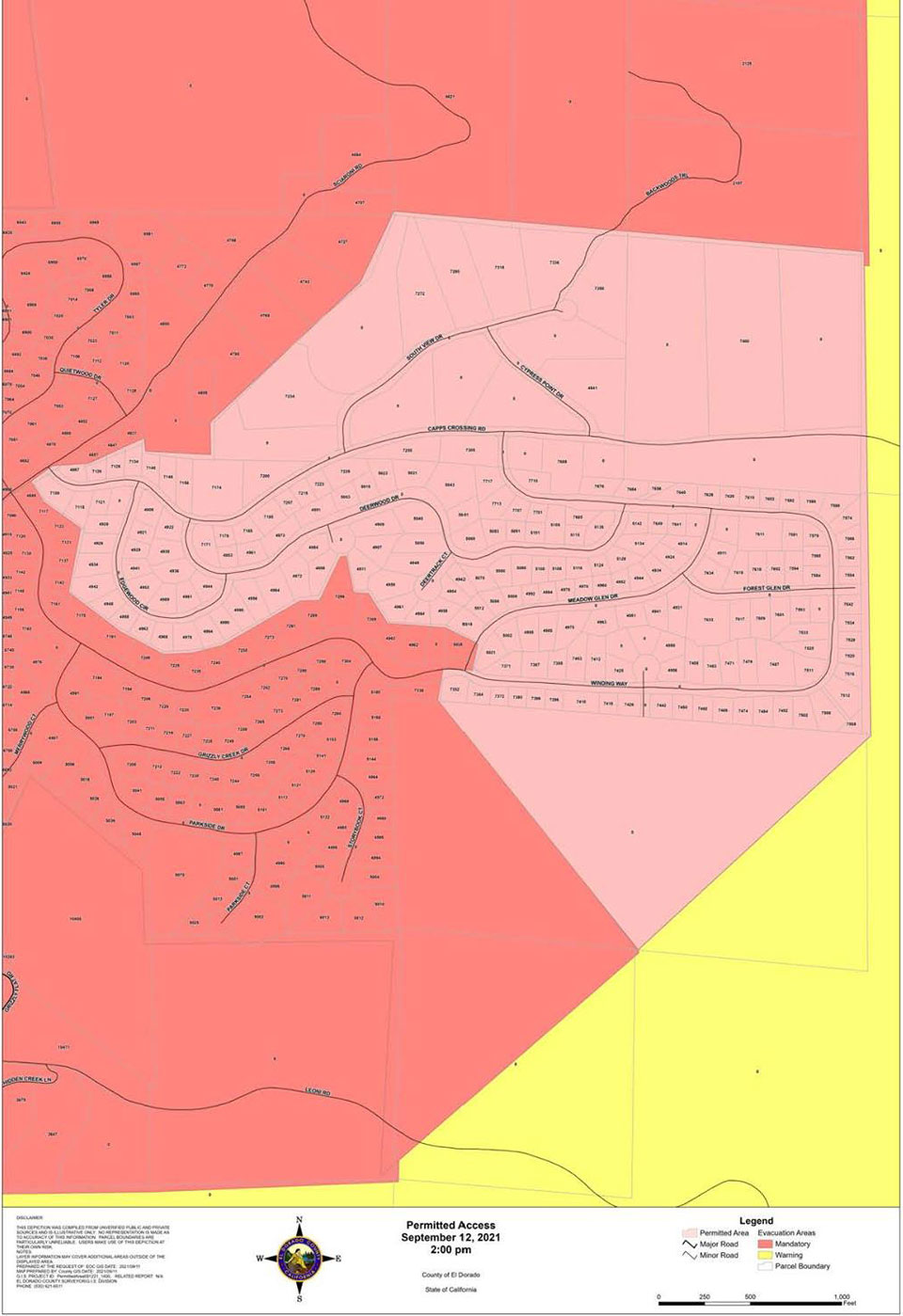
- In the area between the intersection of Sciaroni and Capps Crossing and Meadow Glen and Winding Way, you should have received a Code Red message giving you a 24-hour notice that your area is scheduled to be repopulated starting Sunday, Sept. 12th at 2:00 P.M. Please arrive at Pioneer Park at 2:00 P.M. with proof of residency and a government ID or a government ID that shows your address.
Red area indicates Evacuation.
Yellow area indicates Evacuation Orders downgraded to Warning.
Pink area indicates Permitted Access by El Dorado County Sheriff.
The below map indicates Permitted Access Area #1 - 8:00 A.M.
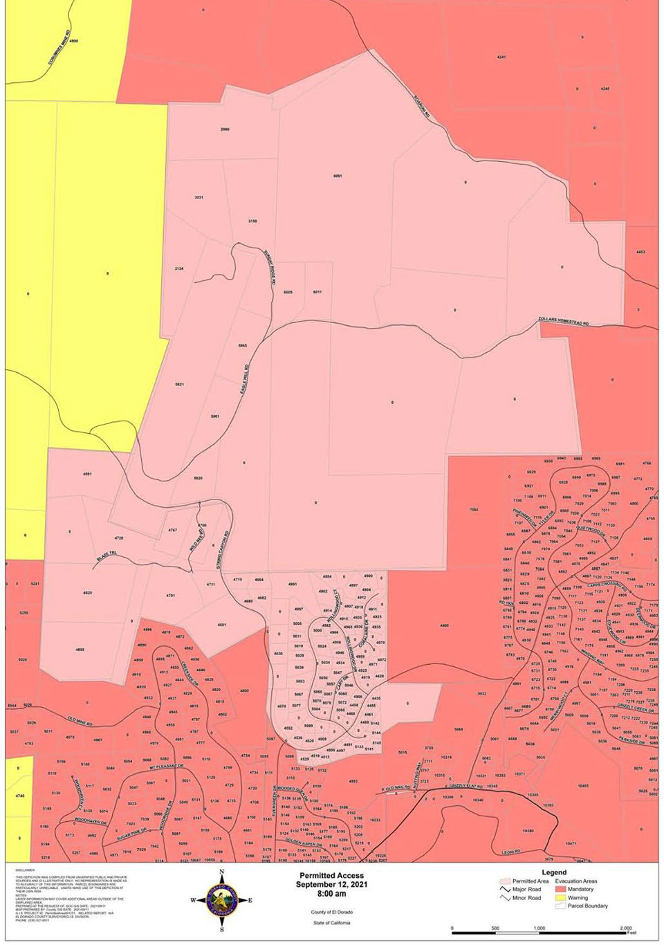
Red area indicates Evacuation.
Yellow area indicates Evacuation Orders downgraded to Warning.
Pink area indicates Permitted Access by El Dorado County Sheriff.
The below map indicates Permitted Access Area #2 - 11:00 A.M.
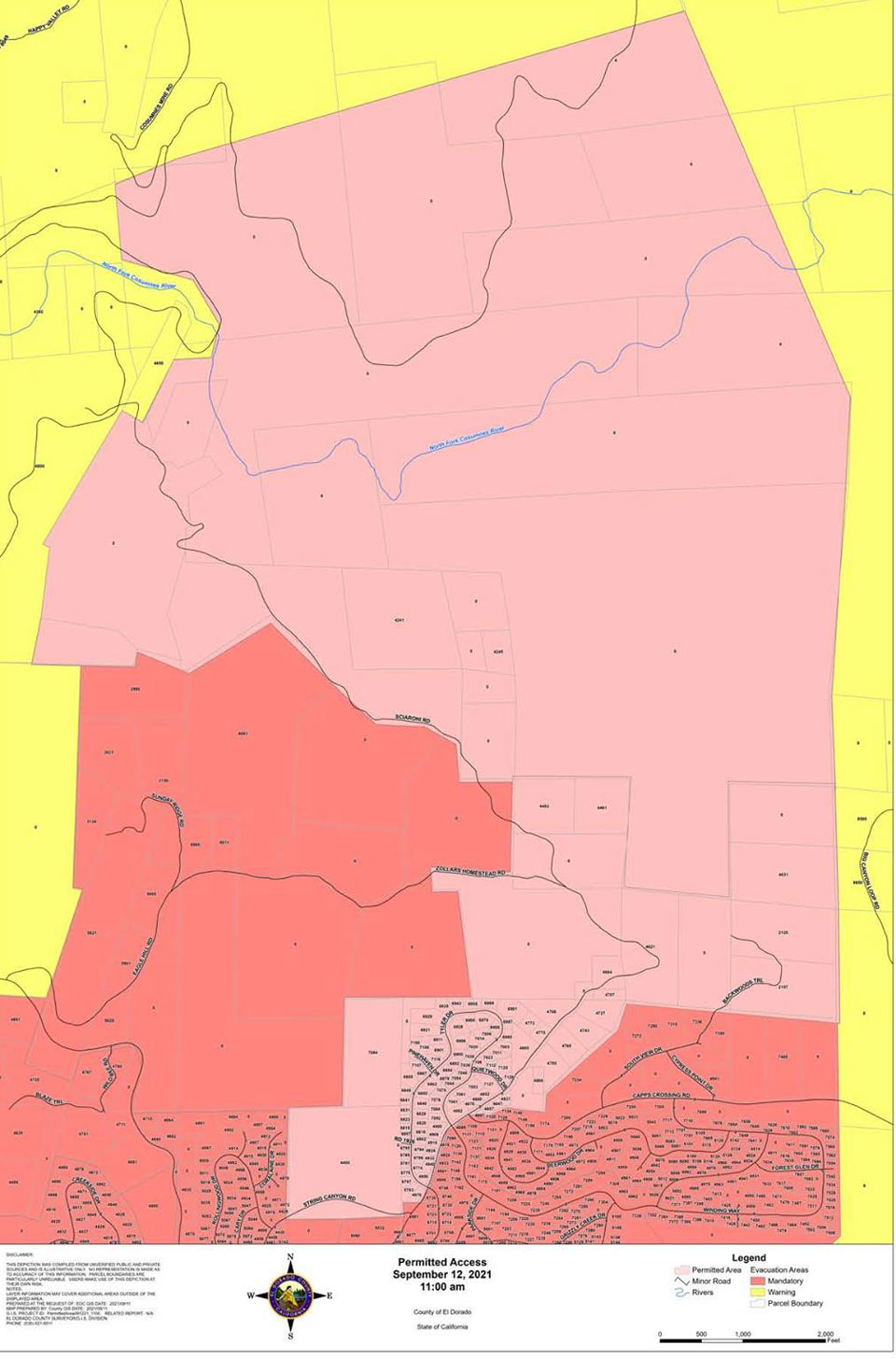
Red area indicates Evacuation.
Yellow area indicates Evacuation Orders downgraded to Warning.
Pink area indicates Permitted Access by El Dorado County Sheriff.
The below map indicates Permitted Access Area #3 - 2:00 P.M.