


Slightly above normal temperatures this summer.
Near to slightly below normal summer “monsoonal” thunderstorm activity.
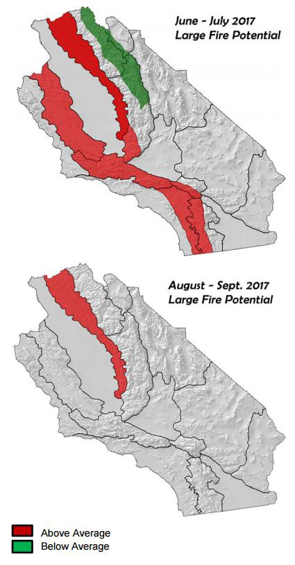
Large fire potential is expected to be above normal through July across many inland valleys, foothills and valleys due to a heavy grass crop.
Large fire potential will remain above normal along the Sierra Foothills through the fall.
Below normal large fire potential in the Sierra high country until meltout occurs above 9,000 feet
June 5, 2017 - Weather Discussion
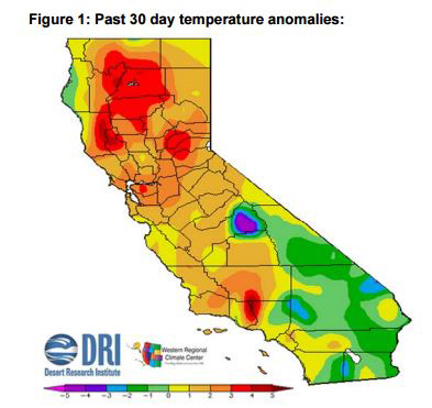
 Much warmer weather developed in May in response to a strong ridge of high pressure which was present over the eastern Pacific during the past few weeks. Although offshore winds were minimal, daytime temperatures climbed to above normal over much of the district. The warmest period of weather for many occurred during the weekend of May 20th into the following week when some valleys and lower foothills reached 100 for the first time this season. As a whole, most of the district will finish the month with slightly above normal temperatures for May, the exception being the desert where onshore flow kept a bit more moderate compared to normal (see Figure 1, below).
Looking ahead to the summer, sea surface temperatures across the subtropical regions of the Pacific are above normal at the current time. This stands in contrast with the pooling of colder than normal water in the Gulf of Alaska and the Pacific Northwest. Cold water in this region is likely responsible for the semi-permanence of a low pressure system over the northwestern section of the country. Stronger than normal jet energy, which may be resulting from the SST gradient across the Pacific,seems to be the driving force behind the development of these systems. But recent trends indicate there may be some warming of SST’s in the Gulf of AK which would perhaps lessen the strength of the jet stream going forward into the summer.
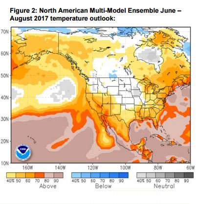
Official outlooks from the National Hurricane Center regarding the Pacific hurricane season call for a 40% chance of an above-normal season, a 40% chance of a near-normal season, and a 20% chance of a below normal season in terms of tropical activity this summer and fall. Based on this as well as recent SST trends, the warmer water to our south may be a bigger player in the summer’s weather pattern than the cold water to our north. Presuming this trend continues, there is a better than even chance that temperatures this summer will average above normal. Most long term models indicate much of the West will see above normal summertime temperatures, especially along the West Coast and in the Southwest. The North American MultiModel Ensemble, comprised of a blend of NOAA, NASA and Canadian models, keeps much of South Op’s area in a 60-70% chance of above normal temperatures this summer (Figure 2, below)
This same long term model guidance blend was forecasting a below normal number of “monsoonal” storms for the district this summer. But recent runs have brought the main moisture axis a bit further west and this summer’s thunderstorm activity – while still expected to be below normal – may not be quite as scant as was expected from previous NMME iterations.
Last year was one of the quieter summer thunderstorm seasons during the past 15 years. While the lack of storms kept an important ignition source (lightning) from starting much activity, a lack of convection allowed fuels to be even drier than would have been the case in a normal year. Fire activity, as a result, was extremely aggressive all summer in the high country. The previous 3 summers were extremely wet in the Sierras and some areas of southern California near the higher terrain. This year, an average to slightly below normal number of storms may be expected. However, if the prediction of an active Pacific hurricane season occurs, thunderstorm activity may increase over Southern California in August and September.
FUELS AND DROUGHT OUTLOOK:
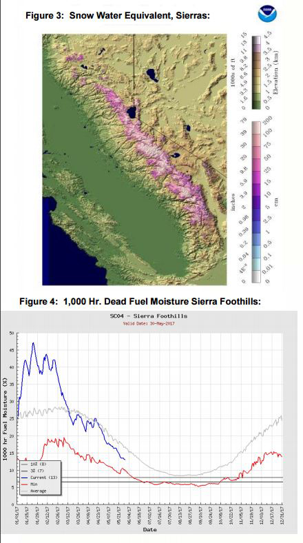 Warm weather during the latter half of May allowed snowmelt over the Sierras to accelerate. Although the snow field is very deep over the highest elevations, areas below 9,000 feet have seen substantial meltout during the past few weeks. Some areas have melted out completely across exposed and open locations (Figure 3, left). This may allow some areas which were recently snow covered to see some fire activity in July. However, elevations at 9,000 feet may not see fire potential climb until August, if at all.
 During the period of warm weather in May, there was a flurry of fire activity across the entire district. Much of this was due to the heavy grass crop of winter curing out and being highly receptive to ignition on hot days. Fuel loading in the hills and urban interface regions is much greater this year and there may continue to be a significant amount of initial attack on hot or windy days until the density of the grass crop decreases during the middle to latter stages of summer.
Once this occurs, the area with the highest threat of large fires may continue to be focused on the Sierra Foothills where the heavy grass crop interfaces with a high amount of bug killed timber. Dead fuel moisture in these areas is still a bit above average (figure 4, left bottom), but once these heavy, dead fuels dry out, very active fire behavior will be possible on hot or windy days. Fire may quickly transition from the grasses into the heavier fuel types when weather conditions are supportive of rapid fire growth. Summertime “monsoonal” thunderstorm duration and coverage is not expected to be sufficient to reduce fire danger in these areas. Therefore, mainly due to fuel conditions, large fire potential will remain above normal in the Sierra Foothills through the fall until wetting rains arrive this winter
Source: GACC
