


 Highlights:
 (1) Above normal temperatures through the summer.
(2) Near to slightly below normal summer “monsoonal” thunderstorm activity.
(3) Large fire potential is expected to be above normal across many inland valleys, foothills and valleys due to a heavy grass crop comingled with bug-killed and drought damaged timber.
(4) Below normal large fire potential in the Sierra high country until meltout occurs above 9,000 feet.
(5) Live fuels becoming critically dry over Southern California by early August.
Weather Discussion
While last month started off in the typical “June Gloom” fashion, a substantial heatwave occurred during the second half of the month. One of the strongest ridges of high pressure in recent years developed over the Southwest, extending into the Eastern Pacific. Temperatures during the third week of the month soared to 15 to 20 degrees above normal. The worst of the heatwave extended across the desert and into Arizona where many daily maximum temperature records were set. The temperature gradient between the coast and desert was more pronounced than usual as the coastal valleys and adjacent foothills remained relatively cool. But the mercury routinely roared to over 105 degrees for nearly two weeks in the San Joaquin Valley and lower foothills which resulted in an intense uptick in fire activity in Central California. Initial attack was moderate to approaching heavy during the last two weeks of the month in response to the hot weather and drying fuels.
July usually marks the beginning of the Southwestern Monsoon for California. This year, latest computer models indicate the onset of the monsoon looks to be right on time with thunderstorms becoming a possibility during the first week of the month. But the upcoming monsoon surge notwithstanding, a slightly below normal amount of summer thunderstorms looks to be a decent possibility.
Longer range models are indicating the synoptic pattern may favor prolonged southwesterly flow again this summer. High pressure looks to remain over the southwest and northern Mexico for much of the summer. Infrequent troughs from the Gulf of Alaska may help deflect much of the monsoonal moisture east of the area by establishing a drier, southwesterly flow (see figure 1 below)
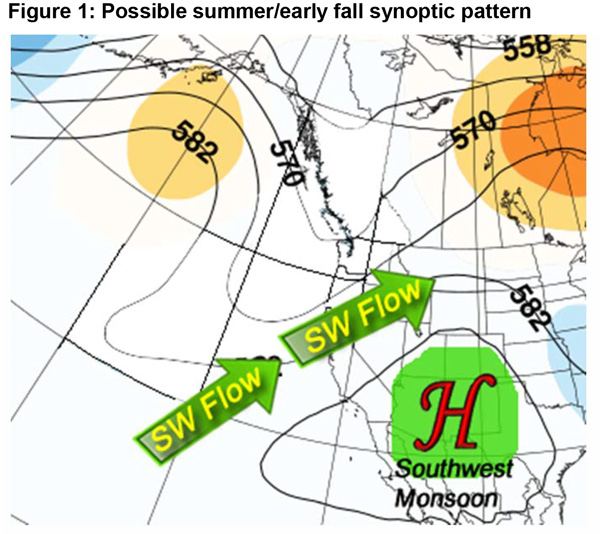
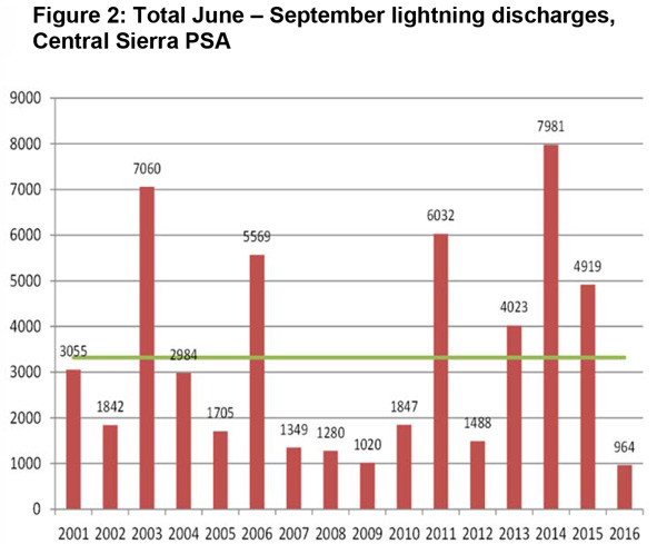
This pattern occurred with regularity last summer, which resulted in one of the least active monsoon seasons in years (see figure 2 below). Last year, the total number of lightning discharges across the Sierras was under a third of normal. Other areas had an even greater departure from average. While this year may be less active than normal, it is highly likely that more storms will occur this summer than last year. Therefore, there is a greater chance of seeing new starts from lightning this year, even though live fuel moisture is currently higher this year than recent years.
The Central Pacific Hurricane Center is forecasting an above normal hurricane season this year. This outlook is partially based on an El Niño being present this summer and fall. If an El Niño continues the next few months, there is a greater tendency for tropical systems to travel westward into the Central Pacific (and away from California) which would also result in the potential for fewer thunderstorms this summer.
Nearly all available long term model guidance points to a strong possibility of above normal temperatures this summer into the fall. With the expected close proximity of the high pressure ridge to our east, this isn’t too surprising. Sea surface temperatures are also above normal off the Southern and Central California coast which may also contribute to above normal temperatures this summer.
It is too early to predict the frequency or severity of offshore wind events this fall. Most patterns supporting or hindering the development of offshore flow do not become obvious until a month or so prior to the start of fall. But like most years, due to the drier than normal summer and fall expected, fuel moisture will likely be extremely low by the time the first east wind episode occurs.
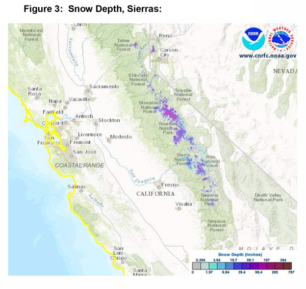
Therefore, due to fewer than average number of storms this summer and the strong possibility of hotter than normal conditions the next 3 months, large fire potential is expected to remain above normal across most inland valleys, mountains and foothills. The high Sierra, which still has significant fuel moisture and snow cover (see figure 3 below) will probably have below normal large fire potential for several more weeks – or at least 3-5 weeks after “snow off” occurs.
Fuels and Drought Outlook
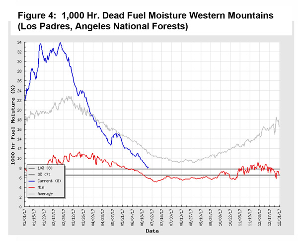
The hot and dry weather last month pushed most smaller diameter dead fuels into an extremely dry state. These fuels, along with the heavy crop of cured grasses, are what allowed for several days of heavy initial attack during the past two weeks. Dead fuels (of which there is a great deal of) will continue to be the primary driver of fires in July as live fuel moisture continues to be above normal over most areas at the current time. Heavier dead fuels are still holding onto a fleeting amount of moisture (see figure 4 below). But before the end of the month, all dead fuels should be dry enough to carry fire.
Although much of the district is forecast to have a higher than normal large fire potential, the Sierra Foothills will likely have the highest potential of large fires due to the continued presence of a heavy grass crop and millions of bug killed trees. These large diameter fuels will probably become dry enough to allow transition of fires from the ground fuels into the canopy during hot or windy periods. Such fires may grow exceptionally fast where slope and terrain are in alignment and will be challenging to suppress. There have already been several fires in this area and the expectation is that they will become more numerous and more active once the bug killed timber becomes dry enough to accept ignition later in July.
This fire season may be more challenging than other recent years for a few reasons. Unlike the past 5 years when live and dead fuels alike were critically dry by summer, this year, there is a lot more variability regarding fuel moisture conditions with respect to aspect, type and elevation. For instance, one location may have a high amount of live vegetation and would only support moderate growth but an area immediately adjacent, more exposed area may have much more receptive and combustible fuels. Fire personnel will have to be especially vigilant in observing fuel conditions as fire behavior may be more unpredictable this summer due to a more varied collage of fuel moisture conditions.
Source: Predictive Services
