


 Highlights:
(1) Above normal temperatures through the summer and fall.
(2) Near to slightly below normal summer “monsoonal” thunderstorm activity
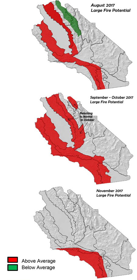
(3) Large fire potential will be well above normal across most areas outside the desert and irrigated areas into the fall
(4) Live fuels becoming critically dry over Southern California by early to mid-August, and in September across Central California
Weather Discussion
The hot weather that developed in late June continued through most of July. Temperatures last month averaged 4-6 degrees above normal over much of the area with readings over 100 degrees for several days in the valleys and lower foothills. The hot weather was accompanied by low RH across much of the interior sections of Central California. The southern part of the state generally had higher RH during the past month, mainly due to weak monsoon surges mixing with the marine layer.
Precipitation was generally below normal with the monsoon only producing one to two day events during each surge. Storm coverage and frequency, while greater than last year, could still be classified as below normal as most storms remained near the Arizona and Nevada borders. Southern California, in particular, experienced less precipitation this past July compared with other recent years.
The southwesterly flow aloft which dominated the spring, slowly shifted to more of a southerly direction during the past 30-40 days. High pressure was often located off the coast while a stronger ridge remained over the southern Rockies. This kept temperatures very warm, but the deep, sustained moisture often associated with southerly flow was absent much of the time. The monsoon started on a quite note, but as the tropics became increasingly loaded with moisture, heavy rains fell on the Southwest. But the high over the Southwest remained too far east to allow for southeast flow to bring moisture into California.
Significant warming seems to be occurring across much of the central and eastern Pacific. This warming may support more ridging along the West Coast during the next couple of months as the strength of the Pacific Northwest troughs may weaken. This had been the trend during the past several weeks as troughs in the Gulf of Alaska and off the British Columbian coast have been weaker than usual. (see below)
Figure 1: Sea Surface Temperatures, Pacific
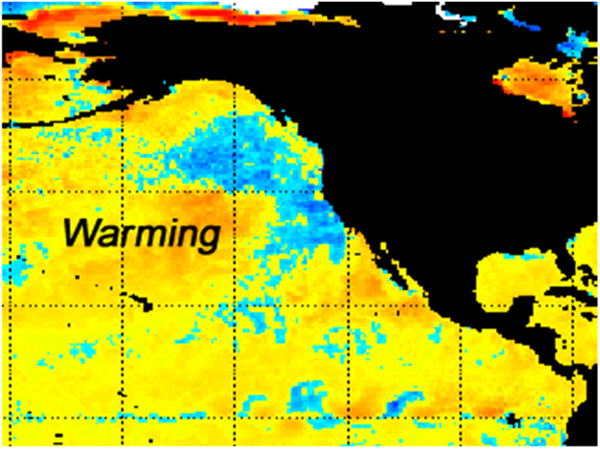
Seattle has recorded one of its driest July’s on record partially due to the weakening of the trough. At the time of this writing, strong high pressure is expected to build over Northern California and Nevada during much of August. All long term model guidance appear to be painting the same picture with regards to the well above normal temperatures expected the rest of the summer into fall.
The outlook of above normal hurricanes in the eastern Pacific has come true as the number of named storms is above average for this time of year. These systems have drifted out to sea for the most part, but tropical systems remain the wildcard in this outlook. Models indicate below normal precipitation should continue for several more weeks as high pressure will keep the monsoon directed east of the state. But the high number of tropical systems could introduce a very small likelihood of seeing some rainfall if the remnants of these storms enter the region. But aside from that possibility, precipitation should be below normal through rest of the monsoon season.
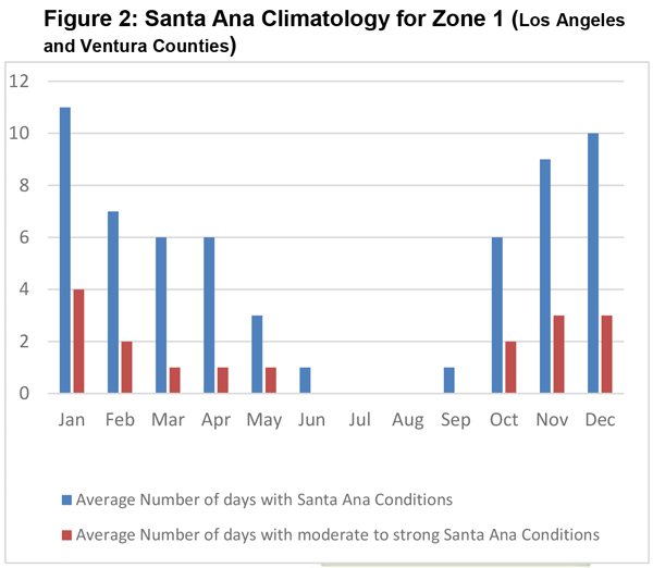
Since conditions are likely to be extremely dry heading into the fall, attention turns to what the upcoming offshore wind season might be like. Offshore wind forecast usually only have any kind of skill 2-3 weeks out, but in general sense, some trends can be discussed. Currently, a weakly positive ENSO signal continues over the eastern Pacific. Most ensemble members keep sea-surface temperatures flat at a point just above the normal line through the fall. Given this, it is unlikely a strong positive or negative ENSO will develop this year.
The expectation of a near neutral ENSO (along with a near neutral NAO) may lead to a near normal number of offshore wind events this fall (see Figure 2, below). There is some correlation between a negative NAO and an increase in offshore wind events, but in the absence of this condition, there is a better chance the number of offshore wind events will be close to the climatological normal. (This does not address the severity of any particular event).
Offshore winds will likely precede any meaningful wintertime precipitation over Southern California. Therefore, above normal large fire potential will be possible over much of the area prone to offshore winds well into the fall, and possibly the early winter.
Fuels and Drought Outlook
 Hot, dry weather caused dead fuels to dry to near record low readings in both fine and heavy fuels. All dead fuels have become uniformly dry across the entire district and are at the point where burning indices and energy release components will be near record levels during hot periods; of which there will be many in coming weeks and months.
Live fuel moisture is more of a mixed bag, but Southern California has seen readings drop to below normal for this time of year. At the current rate of drying, expect live fuels to reach critical dryness by the end of August in these areas. Once this occurs, all fuel types will accept flame readily and will allow for rapid rates of spread during the afternoon hours or during windy periods. The only area where fuels remain relatively moist is at the upper elevations of the Sierras. But “snow off” should occur over most vegetated areas during August which may allow some of these areas to see fire activity in September.
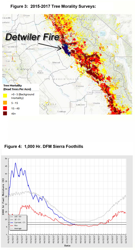
The combination of a heavy cured grass crop along with a high concentration of bug-killed timber will continue to pose a dangerous situation in the Sierra Foothills in particular. The Detwiler fire became established in light fuels at low elevations and quickly raced into the heavier timber where control was much more difficult (Figure 3). Large fire potential will continue to be exceptionally high in this area until cooler weather, and perhaps wetting rains, return in October. Likewise, large fire potential will drop to near normal over most areas from north to south during the middle of the fall. Expect some fire potential to linger across Southern California later than usual this year. There is a possibility that winter precipitation may be below normal this year over Southern California if the forecast of a Modoki El Niño comes true.
This fall may be one of the more active and dangerous seasons in years due to the high amount of fuel loading from last winter’s rains and the remnant stands of dead vegetation. Proper use of safety protocol, including LCES, will be critical when engaged with the hostile fuel and weather conditions expected the next several months.

